
Downie Hillock


Fort (Iron Age)
Site Name Downie Hillock
Classification Fort (Iron Age)
Alternative Name(s) Dounie Hillock
Canmore ID 15531
Site Number NH95NE 5
NGR NH 9675 5815
Datum OSGB36 - NGR
Permalink http://canmore.org.uk/site/15531


- Council Moray
- Parish Dyke And Moy
- Former Region Grampian
- Former District Moray
- Former County Morayshire
NH95NE 5 9675 5815
(NH 9675 5815) Fort: Downie (? Dounie) Hillock.
Visible on AP's (RAF/F22.58/1116:0340-1).
(Undated) information in NMRS.
The foundations of a fort were traced on Downie Hill by Mr John McEwan, minister of Dyke till 1914.
W Dyke 1966.
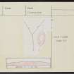
On Downie Hillock, an afforested knoll commanding extensive views in all directions, there is a fort. No trace of defences can be seen around the perimeter of the level oval summit of the knoll which measures 34.0m N-S by c.18.0m transversely, but at a lower level there is a terrace about 2.0m wide formed by scarping the slope. The entrance is in the S where the terrace widens to c.13.0m to provide space for an additional defence in the form of a short length of ditch flanking a break in the outer defensive scarp.
Surveyed at 1:2500.
Visited by OS (RL), 19 January 1971.
After the clearing of trees from the fort interior and perimeter, a low bank on the southern edge of the interior can now be seen. (GRC NH95NE 11).
Sponsor: Grampian Regional Council.
I Shepherd 1991i.
Field Visit (19 January 1971)
On Downie Hillock, an afforested knoll commanding extensive views in all directions, there is a fort. No trace of defences can be seen around the perimeter of the level oval summit of the knoll which measures 34.0m N-S by c.18.0m transversely, but at a lower level there is a terrace about 2.0m wide formed by scarping the slope. The entrance is in the S where the terrace widens to c.13.0m to provide space for an additional defence in the form of a short length of ditch flanking a break in the outer defensive scarp. (GRC NH95NE 11)
Surveyed at 1:2500.
Visited by OS (RL) 19 January 1971
Field Visit (1991)
After the clearing of trees from the fort interior and perimeter, a low bank on the southern edge of the interior can now be seen.
Sponsor: Grampian Regional Council.
I Shepherd 1991i.
Note (25 March 2015 - 31 May 2016)
The remains of a small fortification can be seen on the Downie Hillock, which is a relatively prominent knoll in a small forestry plantation in the low undulating country W of Brodie Castle. It is oval on plan, and the visible defences comprise a single rampart reduced to little more than a scarp that can be traced round the margin of the summit, which measures about 34m from N to S by 18m transversely (0.05ha). The whole clearing is clothed in a deep litter of dead bracken, obscuring the character of the rampart and a slight terrace that extends along the W flank below the scarp and is possibly linked to the shallow ditch with an external bank that can also be seen at the S end. Both this bank and ditch and the inner scarp are pierced by an entrance on the S.
Information from An Atlas of Hillforts of Great Britain and Ireland – 31 May 2016. Atlas of Hillforts SC2917

