
Wester Rarichie


Dun (Prehistoric)
Site Name Wester Rarichie
Classification Dun (Prehistoric)
Canmore ID 15302
Site Number NH87SW 8
NGR NH 84068 73654
Datum OSGB36 - NGR
Permalink http://canmore.org.uk/site/15302


- Council Highland
- Parish Nigg (Ross And Cromarty)
- Former Region Highland
- Former District Ross And Cromarty
- Former County Ross And Cromarty
NH87SW 8 8406 7366.
(NH 8406 7366) 250m W of the fort (NH87SW 6) is a hillock, on top of which are slight remains of a bank; the inner side forms an eroded lip of turf falling steeply into a depression which is up to 0.5m deep. The whole is about 12m NW-SE by 11m transversely. The depression is broken only at the SE, from which issues a track to the S base of the hillock. At the NW part of the bank is a flat portion some 6ft by 9ft; otherwise the artificial hollow takes up the whole of the top. Apart from a trace near the eroded position on the NE face, there appears to be no other artificial bank or ditch - and this too, may be natural.
Information from J Howdle to OS, 29 August 1961; Visible on RAF air photographs CPE/Scot/UK/223: 4149-50: flown 27 June 1947.
This structure crowns the top of a prominent knoll which has been levelled to accommodate it. It consists of a circular turf-covered rubble wall spread to an average of 5.0m and measures overall 20.0m in diameter. There is a mutilated entrance gap in the E. There is no doubt that it has been a dwelling, similar to that overlying the fort to the SE (NH87SW 6), and is probably best classififed as a homestead.
Surveyed at 1:2500.
Visited by OS (A A) 18 September 1964.
(NH 8406 7366) Homestead (NR)
OS 1:10,000 map, (1981)
A circular structure in a good defensive position on the summit of a knoll, as described by the previous OS field surveyor. It is very similar to the dun some 250m to the E (NH87SW 6) in respect of its position, size and condition, and for the same reason is itself more likely to be a dun than a hut circle, though it is severely reduced. A curving line of the base course of an outer wall face, 2.2m long, is exposed in the side of the knoll about 1.0m below summit level in the SW periphery of the structure. This may indicate a part of the structure, in which case the wall at this point is spread to 6.0m - 8.0m or it may be the remains of an outer defence. There is no other evidence for a possible outer work. Listed as a dun (RCAHMS 1979).
RCAHMS 1979; Visited by OS (N K B) 10 March 1981.
Field Visit (September 1977)
Wester Rarichie NH 840 736 NH87SW 8
This dun occupies the summit of a prominent knoll 250m W of Easter Rarichie fort (no. 182). It measures 10.5m in diameter within a wall spread to between 5m and 6.5m in thickness. An entrance is visible on the E.
RCAHMS 1979, visited September 1977
Geophysical Survey (2013)
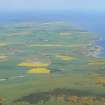
NH 8434 7360 (Easter Rarichie) and NH 8406 7366 (Wester Rarichie) Two excavation sessions were undertaken in 2013 at Easter and Wester Rarichie, by a team from the Department of Archaeology at the University of Aberdeen. The sites are located on two rocky knolls c180m apart at the base of the NE slopes of the Hill of Nigg, on the E coast of the Tarbat Peninsula. The hill of Easter Rarichie is occupied by a multivallate hill fort crowned by a stone and rubble built roundhouse or dun at its summit. The site on Wester Rarichie hill consists of a turf walled roundhouse and a series of ditches and banks located on a summit plateau. Both are prominent hills in the landscape and command clear views across the Tarbat peninsula and the Dornoch and Moray Firths.
Geophysical and measured surveys were undertaken on the sites in January 2013, and two phases of excavations and further geophysical surveys were undertaken in April and July 2013. Four trenches were excavated on Easter Rarichie, targeting the roundhouse, the rampart walls encircling it and a flat terrace area on the lower slopes. On Wester Rarichie a single trench was excavated through the summit roundhouse.
The excavations on Easter Rarichie identified a well preserved stone built roundhouse with internal postholes, occupation surfaces and a stone-built hearth. A trench through the two walls enclosing the summit showed these to be stone-faced earth and rubble walls. Activity in the form of postholes, midden deposits and paved areas was identified in the areas between the rampart walls. The terrace trench identified a series of paved areas, postholes and a metalled surface. A fragment of shale bracelet was recovered from a posthole within the interior of the roundhouse, and animal bone was retrieved from a number of deposits within each of the trenches.
A single radiocarbon date of c400–205 cal BC (SUERC-46744) was obtained from a layer of charcoal underlying the stone wall of the summit roundhouse. A further six radiocarbon samples have now been submitted from various deposits.
The trench across the earthen bank and its interior on the summit of Wester Rarichie identified the structure as a turf walled roundhouse. Within the interior a series of postholes and one end of a possible rectangular structure with a well-worn entranceway were identified. Animal bone and fragments of burnt clay were recovered from a number of features within the interior of the roundhouse, and a fragment of cannel coal bracelet was recovered from one of the postholes. Radiocarbon samples from the internal features of the dun have been submitted.
Archive: RCAHMS
Funder: University of Aberdeen Development Trust in partnership with the Tarbat Discovery Centre
Candy Hatherley and Gordon Noble, University of Aberdeen, 2013
(Source: DES)

