
Shandwick, Burying Ground


Burial Ground (Post Medieval)
Site Name Shandwick, Burying Ground
Classification Burial Ground (Post Medieval)
Alternative Name(s) Old Shandwick
Canmore ID 15277
Site Number NH87SE 3
NGR NH 8556 7473
Datum OSGB36 - NGR
Permalink http://canmore.org.uk/site/15277


- Council Highland
- Parish Nigg (Ross And Cromarty)
- Former Region Highland
- Former District Ross And Cromarty
- Former County Ross And Cromarty
NH87SE 3 8556 7473.
(NH 8556 7473) Burying Ground (Site of) (NAT)
OS 6" map, Ross-shire, 2nd ed., (1889)
The burial ground at Shandwick was last used during the cholera pestilence of 1832 and was ploughed down by the tenant of the farm c. 1885.
H Miller 1889.
No trace.
Visited by OS (A A) 29 August 1972.
Note (1979)
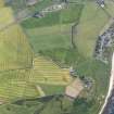
Shandwick, Cross-slab and Burial-ground+ NH 855 747 NH87SE 3 & 4
This well-preserved cross-slab, known as the Clach a' Carridh, is of Early Christian date; it measures 3m in height, 1 m in width and 0.34m in thickness. An associated burial-ground is reported to have been levelled about 1885.
RCAHMS 1979
(Stat Acct, xiii, 1794, 19; Allen and Anderson 1903, iii, 68-73; Macdonald and Laing 1970, 137)
Geophysical Survey (11 September 2013 - 13 September 2013)
NH 8555 7471 and NH 8556 7473 A resistance survey was undertaken, 11–13 September 2013, in the field around the Shandwick stone – a Pictish cross slab dating to the 7th or 8th century AD. The survey aimed to contextualise the landscape location of the stone as part of the Northern Picts: Archaeology of Fortriu project. The survey was focused on the area to the S and E of the Shandwick stone (an area to the NW has previously been surveyed by the University of York). A total of nine 20 x 20m grids were surveyed using a TR/CIA resistance meter. The area was walked in 1m transect lines and measurements were taken every 0.5m.
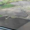
The survey recorded a number of anomalies, including regular rows of small sub-rectangular anomalies to the E and S of the stone. The anomalies to the E may relate to a known burial ground, which was used until the 1830s before being ploughed out in the 1880s by the tenant farmer (NH87SE 3). The anomalies to the S of the stone included suggestions of stone-built structures and further grave-like anomalies. One of these was sampled and human remains were identified under the ploughsoil. Dating of a loose fragment of bone has identified the burial as being of 18th-century date (SUERC-49032 182±30), indicating that the area around the Shandwick stone has been extensively used for burial in recent centuries.
Archive: University of Aberdeen
Funder: University of Aberdeen, Development Trust, University of Aberdeen and Tarbat Discovery Centre
Gordon Noble and Oskar G Sveinbjarnarson, University of Aberdeen, 2013
(Source: DES)

