|
Manuscripts |
MS 2776/1/14 |
Historic Scotland Archive Project |
Survey archive: Site record sheets, site record sheets with field notes and monument forms from the Inner Moray Firth (Moray, Beauly and Cromarty Firth) Coastal Assessment Survey. Sheet 14. |
9/1998 |
Item Level |
|
|
Prints and Drawings |
BD 104/1/14 |
Historic Scotland Archive Project |
Survey archive: 1:25,000 OS Pathfinder map depicting site locations from the Moray, Beauly and Cromarty Firth Coastal Assessment Survey. Sheet 14. |
9/1998 |
Item Level |
|
 |
On-line Digital Images |
DP 341324 |
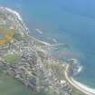
Papers of James Sloan Bone, landscape historian, Inverness, Highland, Scotland |
General oblique aerial view of Balintore, Tarbat Ness, Easter Ross, looking E. |
18/5/2008 |
Item Level |
|
 |
Digital Files (Non-image) |
WP 007515 |
Publications by the Royal Commission on the Ancient and Historical Monuments of Scotland |
(6) The Archaeological Sites and Monuments of Easter Ross, Ross and Cromarty District |
2/1979 |
Item Level |
|
 |
On-line Digital Images |
SC 2367825 |
Records of the Ordnance Survey, Southampton, Hampshire, England |
Balintore, NH87NE 8, Ordnance Survey index card, Recto |
1958 |
Item Level |
|
 |
On-line Digital Images |
SC 2367826 |
Records of the Ordnance Survey, Southampton, Hampshire, England |
Balintore, NH87NE 8, Ordnance Survey index card, Recto |
1958 |
Item Level |
|
|
All Other |
551 166/1/1 |
Records of the Ordnance Survey, Southampton, Hampshire, England |
Archaeological site card index ('495' cards) |
1947 |
Sub-Group Level |
|


