|
Photographs and Off-line Digital Images |
RC 5154 PO |
Papers of Professor John R Hume, economic and industrial historian, Glasgow, Scotland |
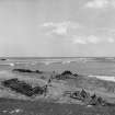
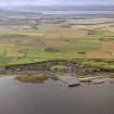
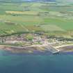
View looking East |
1974 |
Item Level |
|
|
Photographs and Off-line Digital Images |
RC 2547 |
John Dewar |
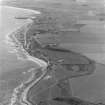
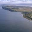
Oblique aerial view showing Hilton of Cadboll and Balintore villages and site of 'Our Lady's Chapel'. |
9/1969 |
Item Level |
|
|
Photographs and Off-line Digital Images |
RC 2548 |
John Dewar |
Oblique aerial view showing Hilton of Cadboll and Balintore villages and site of 'Our Lady's Chapel'. |
9/1969 |
Item Level |
|
 |
On-line Digital Images |
SC 435190 |
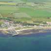
Papers of Professor John R Hume, economic and industrial historian, Glasgow, Scotland |
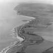
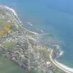
Balintore, Harbour
View of harbour interior and both piers, looking E |
1974 |
Item Level |
|
|
Manuscripts |
MS 726/167 |
Records of CFA Archaeology Ltd, archaeologists, Musselburgh, East Lothian, Scotland |
Coastal Assessment Survey: Inner Moray Firth, Volumes 1 and 2. |
14/12/1998 |
Item Level |
|
|
Manuscripts |
MS 2776/1/14 |
Historic Scotland Archive Project |
Survey archive: Site record sheets, site record sheets with field notes and monument forms from the Inner Moray Firth (Moray, Beauly and Cromarty Firth) Coastal Assessment Survey. Sheet 14. |
9/1998 |
Item Level |
|
|
Prints and Drawings |
BD 104/1/14 |
Historic Scotland Archive Project |
Survey archive: 1:25,000 OS Pathfinder map depicting site locations from the Moray, Beauly and Cromarty Firth Coastal Assessment Survey. Sheet 14. |
9/1998 |
Item Level |
|
 |
On-line Digital Images |
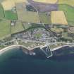
DP 093511 |
RCAHMS Aerial Photography Digital |
Oblique aerial view of Balintore, looking NNW. |
24/7/2010 |
Item Level |
|
 |
On-line Digital Images |
SC 1544662 |
John Dewar |
Oblique aerial view showing Hilton of Cadboll and Balintore villages and site of 'Our Lady's Chapel'. |
9/1969 |
Item Level |
|
 |
On-line Digital Images |
SC 1544663 |
John Dewar |
Oblique aerial view showing Hilton of Cadboll and Balintore villages and site of 'Our Lady's Chapel'. |
9/1969 |
Item Level |
|
|
Photographs and Off-line Digital Images |
J 11837 CS |
Papers of Professor Geraint Dyfed Barri Jones, archaeologist, Manchester, England |
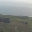
Oblique aerial view |
1987 |
Item Level |
|
 |
On-line Digital Images |
SC 1896757 |
Papers of James Sloan Bone, landscape historian, Inverness, Highland, Scotland |
Aerial view of Balintore, Tarbat Ness, Easter Ross, looking NW. |
1998 |
Item Level |
|
 |
On-line Digital Images |
SC 1896761 |
Papers of James Sloan Bone, landscape historian, Inverness, Highland, Scotland |
Aerial view of Hilton of Cadboll and Balintore, Tarbat Ness, Easter Ross, looking S. |
1998 |
Item Level |
|
 |
On-line Digital Images |
DP 341324 |
Papers of James Sloan Bone, landscape historian, Inverness, Highland, Scotland |
General oblique aerial view of Balintore, Tarbat Ness, Easter Ross, looking E. |
18/5/2008 |
Item Level |
|
 |
On-line Digital Images |
DP 341888 |
Papers of James Sloan Bone, landscape historian, Inverness, Highland, Scotland |
An oblique aerial view of Shandwick, Balintore and Hilton of Cadboll on the Tarbat Peninsula, looking SE. |
17/1/2010 |
Item Level |
|
 |
On-line Digital Images |
DP 343269 |
Papers of James Sloan Bone, landscape historian, Inverness, Highland, Scotland |
Aerial view of Balintore Village and harbour, Tarbat peninsula, looking NW. |
18/6/2014 |
Item Level |
|
 |
On-line Digital Images |
DP 343270 |
Papers of James Sloan Bone, landscape historian, Inverness, Highland, Scotland |
Aerial view of part of Balintore Village and harbour with also part of Hilton of Cadboll, Tarbat peninsula, looking NNW. |
18/6/2014 |
Item Level |
|
 |
On-line Digital Images |
SC 2367844 |
Records of the Ordnance Survey, Southampton, Hampshire, England |
Balintore, Shore Street, Harbour, NH87NE 17, Ordnance Survey index card, Recto |
1958 |
Item Level |
|
 |
On-line Digital Images |
SC 2367845 |
Records of the Ordnance Survey, Southampton, Hampshire, England |
Balintore, Shore Street, Harbour, NH87NE 17, Ordnance Survey index card, Recto |
1958 |
Item Level |
|
|
Photographs and Off-line Digital Images |
BS 97/14 CS |
Historic Scotland Archive Project |
Survey photographs: From the Moray, Beauly and Cromarty Firth Coastal Assessment Survey - Port an Righ, Shandwick, Balintore, Hilton of Cadboll, to Geanie's Point. |
1998 |
Batch Level |
|


