
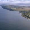
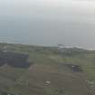
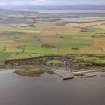
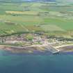
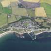
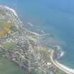
Balintore, Shore Street, Harbour


Harbour (Period Unassigned)
Site Name Balintore, Shore Street, Harbour
Classification Harbour (Period Unassigned)
Alternative Name(s) Balintore Harbour; Shandwick Bay; North Sea
Canmore ID 15251
Site Number NH87NE 17
NGR NH 86400 75490
Datum OSGB36 - NGR
Permalink http://canmore.org.uk/site/15251


- Council Highland
- Parish Fearn
- Former Region Highland
- Former District Ross And Cromarty
- Former County Ross And Cromarty
NH87NE 17 86400 75490
Harbour [NAT]
OS (GIS) MasterMap, July 2009.
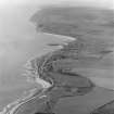
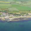
(Location cited as NH 854 754). Harbour, Balintore, late 19th or early 20th century. A simple harbour of enclosure, formed by an L-plan pier and a straight breakwater, both concrete.
J R Hume 1977.
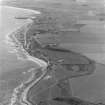
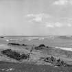
NH 8649 7549 - Harbour. Actively eroding at Western end, probably accreting at Eastern end. Erosion is occurring on and around erosion protection measures. Not effective.
CFA/MORA Coastal Assessment Survey 1998.
Field Visit (2013 - 2014)
Harbour is actively eroding at W end and probably accreting at E end. Erosion occurring on and around erosion protection measures.
Visited by Scotland's Coastal Heritage at Risk (SCHARP) 2013

