
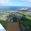
Nairn, Mill Road, Railway Viaduct


Railway Viaduct (19th Century)
Site Name Nairn, Mill Road, Railway Viaduct
Classification Railway Viaduct (19th Century)
Alternative Name(s) River Nairn; Nairn Viaduct
Canmore ID 15139
Site Number NH85NE 50
NGR NH 88605 56237
Datum OSGB36 - NGR
Permalink http://canmore.org.uk/site/15139


- Council Highland
- Parish Nairn
- Former Region Highland
- Former District Nairn
- Former County Nairn
NH85NE 50 88605 56237
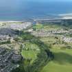
(Location cited as NH 886 563). Nairn Viaduct. A 4-span viaduct with dressed-stone arch rings and piers and coursed-rubble spandrels.
J R Hume 1977.
Railway viaduct, off Mill Road, 1856-7 by Joseph Mitchell.
J Gifford 1992.
The Nairn viaduct was built to the design of Joseph Mitchell at a cost of £8620 for the Inverness and Aberdeen Junction Rly and opened on 18 August 1858. The stone was taken from Kingsteps quarry (NH85NE 465).
M Smith 1994.
This viaduct carries the Inverness-Forres line of the former Highland Rly across the River Nairn to the E of Nairn Station (NH85NE 48.00). It remains in regular use by passenger traffic.
This viaduct is depicted, but not noted, on the 1978 edition of the OS 1:10,000 map. The location assigned to this record defines the midpoint of the structure. The available map evidence indicates that it extends from NH c. 88560 56219 to NH c. 88638 56251.
Information from RCAHMS (RJCM), 24 March 2006.

