
Cardlunchart Hill


Building (Period Unassigned), Cairnfield (Period Unassigned), Enclosure(S) (Period Unassigned), Hut Circle(S) (Prehistoric)
Site Name Cardlunchart Hill
Classification Building (Period Unassigned), Cairnfield (Period Unassigned), Enclosure(S) (Period Unassigned), Hut Circle(S) (Prehistoric)
Alternative Name(s) Culfork
Canmore ID 151117
Site Number NJ41SE 57
NGR NJ 4541 1094
NGR Description NJ 4541 1094 and NJ 4548 1089
Datum OSGB36 - NGR
Permalink http://canmore.org.uk/site/151117


- Council Aberdeenshire
- Parish Towie
- Former Region Grampian
- Former District Gordon
- Former County Aberdeenshire
NJ41SE 57 4540 1094 and 4548 1090
See also NJ41SE 19.
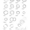
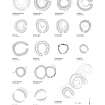
(Location formerly cited as NJ 4540 1094 and NJ 4548 1090: amended to NJ 4541 1094 and NJ 4548 1089 and classification amended to Hut-Circles; Small Cairns; Enclosure; Building). The remains of two hut-circles and four small clearance cairns are situated within an area of rig-and-furrow cultivation that forms the SW end of a larger field-system (NJ41SE 19). The first hut-circle is situated at a break in the gentle NNE-facing slope and measures about 7m in diameter within a heather-grown stony bank about 2m in thickness and 0.2m in height. The second lies 80m to the NW and measures about 5.7m in diameter within a grass- and heather-grown stony bank up to 3m in thickness and 0.4m in height; the interior has been dug into the slope on the W to a depth of 0.5m. A small stance is also levelled into the slope some 5m to the NW; it measures at least 3m in diameter and its leading edge is defined by a low scarp. Immediately to the W of these structures there is a low scarp measuring about 21m in length from N to S, which may mark the lower edge of an area of cultivation.
A later enclosure is attached to the N side of the second hut-circle and measures about 18m from E to W by 10.5m transversely within a stony bank. The bank springs from the ENE side of the hut-circle and returns on the WNW, and the entrance is in the N. At the NE corner of the interior there is a building measuring about 7m from ESE to WNW by 3.8m overall; what may be a partition is marked by a low scarp midway across the interior.
Visited by RCAHMS (JRS), 3 June 1998.

