
Ederline


Farmstead (19th Century)
Site Name Ederline
Classification Farmstead (19th Century)
Alternative Name(s) Ederline Home Farm
Canmore ID 150703
Site Number NM80SE 79.02
NGR NM 87301 03123
Datum OSGB36 - NGR
Permalink http://canmore.org.uk/site/150703
Ordnance Survey licence number AC0000807262. All rights reserved.
Canmore Disclaimer.
© Copyright and database right 2024.
- Correction
- Favourite

SC 1683032
Oblique aerial view centred on the farmstead, taken from the NW.
RCAHMS Aerial Photography
22/11/2001
© Crown Copyright: HES

SC 2127720
Estate Exchange. Ederline. No. 1481 Sales Brochure Title: 'Particulars of the Estate of Ederline, Argyllshire' Includes details of Ederline Mansion House and Estate, grounds, Carron and Corrivalich Farm, Finiechem Farm.
Collection of sale catalogues relating to Scottish estates
24/5/1911
© Courtesy of HES (Estates Exchange collection)

SC 2127721
Estate Exchange. Ederline. No. 1481 Sales Brochure Title: 'Particulars of the Estate of Ederline, Argyllshire' Includes details of Ederline Mansion House and Estate, grounds, Carron and Corrivalich Farm, Finiechem Farm.
Collection of sale catalogues relating to Scottish estates
24/5/1911
© Courtesy of HES (Estates Exchange collection)

SC 2127729
Estate Exchange. Ederline. No. 1481 Sales Brochure Title: 'Particulars of the Estate of Ederline, Argyllshire' Includes details of Ederline Mansion House and Estate, grounds, Carron and Corrivalich Farm, Finiechem Farm.
Collection of sale catalogues relating to Scottish estates
24/5/1911
© Courtesy of HES (Estates Exchange collection)

SC 2127730
Estate Exchange. Ederline. No. 1481 Sales Brochure Title: 'Particulars of the Estate of Ederline, Argyllshire' Includes details of Ederline Mansion House and Estate, grounds, Carron and Corrivalich Farm, Finiechem Farm.
Collection of sale catalogues relating to Scottish estates
24/5/1911
© Courtesy of HES (Estates Exchange collection)

SC 2601528
View from NW
Scottish Farm Buildings Survey
26/9/2002
© Crown Copyright: HES (Scottish Farm Buildings Survey)

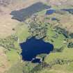
DP 112033
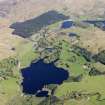
General oblique aerial view of Ford with Loch Ederline adjacent, taken from the SW.
RCAHMS Aerial Photography Digital
2/5/2011
© Crown Copyright: HES

DP 112036
General oblique aerial view of Ford with Loch Ederline adjacent, taken from the SW.
RCAHMS Aerial Photography Digital
2/5/2011
© Crown Copyright: HES

SC 1683033
Oblique aerial view centred on the farmstead, taken from the W.
RCAHMS Aerial Photography
22/11/2001
© Crown Copyright: HES

SC 2127722
Estate Exchange. Ederline. No. 1481 Sales Brochure Title: 'Particulars of the Estate of Ederline, Argyllshire' Includes details of Ederline Mansion House and Estate, grounds, Carron and Corrivalich Farm, Finiechem Farm.
Collection of sale catalogues relating to Scottish estates
24/5/1911
© Courtesy of HES (Estates Exchange collection)

SC 2127726
Estate Exchange. Ederline. No. 1481 Sales Brochure Title: 'Particulars of the Estate of Ederline, Argyllshire' Includes details of Ederline Mansion House and Estate, grounds, Carron and Corrivalich Farm, Finiechem Farm.
Collection of sale catalogues relating to Scottish estates
24/5/1911
© Courtesy of HES (Estates Exchange collection)

SC 2127742
Estate Exchange. Ederline. No. 1481 Sales Brochure Title: 'Particulars of the Estate of Ederline, Argyllshire' Includes details of Ederline Mansion House and Estate, grounds, Carron and Corrivalich Farm, Finiechem Farm.
Collection of sale catalogues relating to Scottish estates
24/5/1911
© Courtesy of HES (Estates Exchange collection)

SC 2127757
Estate Exchange. Ederline. No. 1481 Sales Brochure Title: 'Particulars of the Estate of Ederline, Argyllshire' Includes details of Ederline Mansion House and Estate, grounds, Carron and Corrivalich Farm, Finiechem Farm.
Collection of sale catalogues relating to Scottish estates
24/5/1911
© Courtesy of HES (Estates Exchange collection)

SC 2127758
Estate Exchange. Ederline. No. 1481 Sales Brochure Title: 'Particulars of the Estate of Ederline, Argyllshire' Includes details of Ederline Mansion House and Estate, grounds, Carron and Corrivalich Farm, Finiechem Farm.
Collection of sale catalogues relating to Scottish estates
24/5/1911
© Courtesy of HES (Estates Exchange collection)

SC 2601527
View from NW
Scottish Farm Buildings Survey
26/9/2002
© Crown Copyright: HES (Scottish Farm Buildings Survey)

SC 2601529
View from NNW
Scottish Farm Buildings Survey
26/9/2002
© Crown Copyright: HES (Scottish Farm Buildings Survey)

SC 2601536
View from N
Scottish Farm Buildings Survey
26/9/2002
© Crown Copyright: HES (Scottish Farm Buildings Survey)

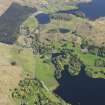
DP 112034
General oblique aerial view of Loch Ederline, taken from the SW.
RCAHMS Aerial Photography Digital
2/5/2011
© Crown Copyright: HES

DP 112035
General oblique aerial view of Loch Ederline, taken from the SW.
RCAHMS Aerial Photography Digital
2/5/2011
© Crown Copyright: HES

SC 2127723
Estate Exchange. Ederline. No. 1481 Sales Brochure Title: 'Particulars of the Estate of Ederline, Argyllshire' Includes details of Ederline Mansion House and Estate, grounds, Carron and Corrivalich Farm, Finiechem Farm.
Collection of sale catalogues relating to Scottish estates
24/5/1911
© Courtesy of HES (Estates Exchange collection)

SC 2127728
Estate Exchange. Ederline. No. 1481 Sales Brochure Title: 'Particulars of the Estate of Ederline, Argyllshire' Includes details of Ederline Mansion House and Estate, grounds, Carron and Corrivalich Farm, Finiechem Farm.
Collection of sale catalogues relating to Scottish estates
24/5/1911
© Courtesy of HES (Estates Exchange collection)

SC 2127731
Estate Exchange. Ederline. No. 1481 Sales Brochure Title: 'Particulars of the Estate of Ederline, Argyllshire' Includes details of Ederline Mansion House and Estate, grounds, Carron and Corrivalich Farm, Finiechem Farm.
Collection of sale catalogues relating to Scottish estates
24/5/1911
© Courtesy of HES (Estates Exchange collection)

SC 2127732
Estate Exchange. Ederline. No. 1481 Sales Brochure Title: 'Particulars of the Estate of Ederline, Argyllshire' Includes details of Ederline Mansion House and Estate, grounds, Carron and Corrivalich Farm, Finiechem Farm.
Collection of sale catalogues relating to Scottish estates
24/5/1911
© Courtesy of HES (Estates Exchange collection)

SC 2127734
Estate Exchange. Ederline. No. 1481 Sales Brochure Title: 'Particulars of the Estate of Ederline, Argyllshire' Includes details of Ederline Mansion House and Estate, grounds, Carron and Corrivalich Farm, Finiechem Farm.
Collection of sale catalogues relating to Scottish estates
24/5/1911
© Courtesy of HES (Estates Exchange collection)

SC 2127739
Estate Exchange. Ederline. No. 1481 Sales Brochure Title: 'Particulars of the Estate of Ederline, Argyllshire' Includes details of Ederline Mansion House and Estate, grounds, Carron and Corrivalich Farm, Finiechem Farm.
Collection of sale catalogues relating to Scottish estates
24/5/1911
© Courtesy of HES (Estates Exchange collection)

SC 2127754
Estate Exchange. Ederline. No. 1481 Sales Brochure Title: 'Particulars of the Estate of Ederline, Argyllshire' Includes details of Ederline Mansion House and Estate, grounds, Carron and Corrivalich Farm, Finiechem Farm.
Collection of sale catalogues relating to Scottish estates
24/5/1911
© Courtesy of HES (Estates Exchange collection)

SC 2601526
View from SW
Scottish Farm Buildings Survey
26/9/2002
© Crown Copyright: HES (Scottish Farm Buildings Survey)

SC 2601530
View from NNW
Scottish Farm Buildings Survey
26/9/2002
© Crown Copyright: HES (Scottish Farm Buildings Survey)

SC 2601531
View of arched entrance to courtyard from W
Scottish Farm Buildings Survey
26/9/2002
© Crown Copyright: HES (Scottish Farm Buildings Survey)

SC 2601537
View from N
Scottish Farm Buildings Survey
26/9/2002
© Crown Copyright: HES (Scottish Farm Buildings Survey)

SC 2601540
View of building to N of main steading from W
Scottish Farm Buildings Survey
26/9/2002
© Crown Copyright: HES (Scottish Farm Buildings Survey)

SC 2601541
View of modern buildings (1984) to N of steading
Scottish Farm Buildings Survey
26/9/2002
© Crown Copyright: HES (Scottish Farm Buildings Survey)

SC 2601542
Detail of manufacturer's plate on building (1984) to N of steading
Scottish Farm Buildings Survey
26/9/2002
© Crown Copyright: HES (Scottish Farm Buildings Survey)

SC 2127724
Estate Exchange. Ederline. No. 1481 Sales Brochure Title: 'Particulars of the Estate of Ederline, Argyllshire' Includes details of Ederline Mansion House and Estate, grounds, Carron and Corrivalich Farm, Finiechem Farm.
Collection of sale catalogues relating to Scottish estates
24/5/1911
© Courtesy of HES (Estates Exchange collection)

SC 2127746
Estate Exchange. Ederline. No. 1481 Sales Brochure Title: 'Particulars of the Estate of Ederline, Argyllshire' Includes details of Ederline Mansion House and Estate, grounds, Carron and Corrivalich Farm, Finiechem Farm.
Collection of sale catalogues relating to Scottish estates
24/5/1911
© Courtesy of HES (Estates Exchange collection)

SC 2127748
Estate Exchange. Ederline. No. 1481 Sales Brochure Title: 'Particulars of the Estate of Ederline, Argyllshire' Includes details of Ederline Mansion House and Estate, grounds, Carron and Corrivalich Farm, Finiechem Farm.
Collection of sale catalogues relating to Scottish estates
24/5/1911
© Courtesy of HES (Estates Exchange collection)

SC 2127752
Estate Exchange. Ederline. No. 1481 Sales Brochure Title: 'Particulars of the Estate of Ederline, Argyllshire' Includes details of Ederline Mansion House and Estate, grounds, Carron and Corrivalich Farm, Finiechem Farm.
Collection of sale catalogues relating to Scottish estates
24/5/1911
© Courtesy of HES (Estates Exchange collection)

SC 2127753
Estate Exchange. Ederline. No. 1481 Sales Brochure Title: 'Particulars of the Estate of Ederline, Argyllshire' Includes details of Ederline Mansion House and Estate, grounds, Carron and Corrivalich Farm, Finiechem Farm.
Collection of sale catalogues relating to Scottish estates
24/5/1911
© Courtesy of HES (Estates Exchange collection)

SC 2127756
Estate Exchange. Ederline. No. 1481 Sales Brochure Title: 'Particulars of the Estate of Ederline, Argyllshire' Includes details of Ederline Mansion House and Estate, grounds, Carron and Corrivalich Farm, Finiechem Farm.
Collection of sale catalogues relating to Scottish estates
24/5/1911
© Courtesy of HES (Estates Exchange collection)

SC 2601525
View from SW
Scottish Farm Buildings Survey
26/9/2002
© Crown Copyright: HES (Scottish Farm Buildings Survey)

SC 2601539
View of building to N of main steading from W
Scottish Farm Buildings Survey
26/9/2002
© Crown Copyright: HES (Scottish Farm Buildings Survey)

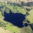
DP 112038
General oblique aerial view of Loch Ederline, taken from the SSW.
RCAHMS Aerial Photography Digital
2/5/2011
© Crown Copyright: HES

SC 2127725
Estate Exchange. Ederline. No. 1481 Sales Brochure Title: 'Particulars of the Estate of Ederline, Argyllshire' Includes details of Ederline Mansion House and Estate, grounds, Carron and Corrivalich Farm, Finiechem Farm.
Collection of sale catalogues relating to Scottish estates
24/5/1911
© Courtesy of HES (Estates Exchange collection)

SC 2127727
Estate Exchange. Ederline. No. 1481 Sales Brochure Title: 'Particulars of the Estate of Ederline, Argyllshire' Includes details of Ederline Mansion House and Estate, grounds, Carron and Corrivalich Farm, Finiechem Farm.
Collection of sale catalogues relating to Scottish estates
24/5/1911
© Courtesy of HES (Estates Exchange collection)

SC 2127737
Estate Exchange. Ederline. No. 1481 Sales Brochure Title: 'Particulars of the Estate of Ederline, Argyllshire' Includes details of Ederline Mansion House and Estate, grounds, Carron and Corrivalich Farm, Finiechem Farm.
Collection of sale catalogues relating to Scottish estates
24/5/1911
© Courtesy of HES (Estates Exchange collection)

SC 2127750
Estate Exchange. Ederline. No. 1481 Sales Brochure Title: 'Particulars of the Estate of Ederline, Argyllshire' Includes details of Ederline Mansion House and Estate, grounds, Carron and Corrivalich Farm, Finiechem Farm.
Collection of sale catalogues relating to Scottish estates
24/5/1911
© Courtesy of HES (Estates Exchange collection)

SC 2601532
View of courtyard from NE
Scottish Farm Buildings Survey
26/9/2002
© Crown Copyright: HES (Scottish Farm Buildings Survey)

SC 2601533
View of courtyard from NE
Scottish Farm Buildings Survey
26/9/2002
© Crown Copyright: HES (Scottish Farm Buildings Survey)

SC 2601535
View of courtyard from W
Scottish Farm Buildings Survey
26/9/2002
© Crown Copyright: HES (Scottish Farm Buildings Survey)

SC 2127733
Estate Exchange. Ederline. No. 1481 Sales Brochure Title: 'Particulars of the Estate of Ederline, Argyllshire' Includes details of Ederline Mansion House and Estate, grounds, Carron and Corrivalich Farm, Finiechem Farm.
Collection of sale catalogues relating to Scottish estates
24/5/1911
© Courtesy of HES (Estates Exchange collection)

SC 2127736
Estate Exchange. Ederline. No. 1481 Sales Brochure Title: 'Particulars of the Estate of Ederline, Argyllshire' Includes details of Ederline Mansion House and Estate, grounds, Carron and Corrivalich Farm, Finiechem Farm.
Collection of sale catalogues relating to Scottish estates
24/5/1911
© Courtesy of HES (Estates Exchange collection)

SC 2127740
Estate Exchange. Ederline. No. 1481 Sales Brochure Title: 'Particulars of the Estate of Ederline, Argyllshire' Includes details of Ederline Mansion House and Estate, grounds, Carron and Corrivalich Farm, Finiechem Farm.
Collection of sale catalogues relating to Scottish estates
24/5/1911
© Courtesy of HES (Estates Exchange collection)

SC 2127749
Estate Exchange. Ederline. No. 1481 Sales Brochure Title: 'Particulars of the Estate of Ederline, Argyllshire' Includes details of Ederline Mansion House and Estate, grounds, Carron and Corrivalich Farm, Finiechem Farm.
Collection of sale catalogues relating to Scottish estates
24/5/1911
© Courtesy of HES (Estates Exchange collection)

SC 2601534
View of courtyard from SE
Scottish Farm Buildings Survey
26/9/2002
© Crown Copyright: HES (Scottish Farm Buildings Survey)

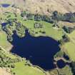
DP 112039
General oblique aerial view of Loch Ederline, taken from the S.
RCAHMS Aerial Photography Digital
2/5/2011
© Crown Copyright: HES

SC 1683034
Oblique aerial view centred on the farmstead, taken from the WSW.
RCAHMS Aerial Photography
22/11/2001
© Crown Copyright: HES

SC 2127735
Estate Exchange. Ederline. No. 1481 Sales Brochure Title: 'Particulars of the Estate of Ederline, Argyllshire' Includes details of Ederline Mansion House and Estate, grounds, Carron and Corrivalich Farm, Finiechem Farm.
Collection of sale catalogues relating to Scottish estates
24/5/1911
© Courtesy of HES (Estates Exchange collection)

SC 2127738
Estate Exchange. Ederline. No. 1481 Sales Brochure Title: 'Particulars of the Estate of Ederline, Argyllshire' Includes details of Ederline Mansion House and Estate, grounds, Carron and Corrivalich Farm, Finiechem Farm.
Collection of sale catalogues relating to Scottish estates
24/5/1911
© Courtesy of HES (Estates Exchange collection)

SC 2127745
Estate Exchange. Ederline. No. 1481 Sales Brochure Title: 'Particulars of the Estate of Ederline, Argyllshire' Includes details of Ederline Mansion House and Estate, grounds, Carron and Corrivalich Farm, Finiechem Farm.
Collection of sale catalogues relating to Scottish estates
24/5/1911
© Courtesy of HES (Estates Exchange collection)

SC 2127751
Estate Exchange. Ederline. No. 1481 Sales Brochure Title: 'Particulars of the Estate of Ederline, Argyllshire' Includes details of Ederline Mansion House and Estate, grounds, Carron and Corrivalich Farm, Finiechem Farm.
Collection of sale catalogues relating to Scottish estates
24/5/1911
© Courtesy of HES (Estates Exchange collection)

SC 1683031
Oblique aerial view centred on the farmstead, taken from the N.
RCAHMS Aerial Photography
22/11/2001
© Crown Copyright: HES

SC 2127719
Estate Exchange. Ederline. No. 1481 Sales Brochure Title: 'Particulars of the Estate of Ederline, Argyllshire' Includes details of Ederline Mansion House and Estate, grounds, Carron and Corrivalich Farm, Finiechem Farm.
Collection of sale catalogues relating to Scottish estates
24/5/1911
© Courtesy of HES (Estates Exchange collection)

SC 2127741
Estate Exchange. Ederline. No. 1481 Sales Brochure Title: 'Particulars of the Estate of Ederline, Argyllshire' Includes details of Ederline Mansion House and Estate, grounds, Carron and Corrivalich Farm, Finiechem Farm.
Collection of sale catalogues relating to Scottish estates
24/5/1911
© Courtesy of HES (Estates Exchange collection)

SC 2127743
Estate Exchange. Ederline. No. 1481 Sales Brochure Title: 'Particulars of the Estate of Ederline, Argyllshire' Includes details of Ederline Mansion House and Estate, grounds, Carron and Corrivalich Farm, Finiechem Farm.
Collection of sale catalogues relating to Scottish estates
24/5/1911
© Courtesy of HES (Estates Exchange collection)

SC 2127744
Estate Exchange. Ederline. No. 1481 Sales Brochure Title: 'Particulars of the Estate of Ederline, Argyllshire' Includes details of Ederline Mansion House and Estate, grounds, Carron and Corrivalich Farm, Finiechem Farm.
Collection of sale catalogues relating to Scottish estates
24/5/1911
© Courtesy of HES (Estates Exchange collection)

SC 2127747
Estate Exchange. Ederline. No. 1481 Sales Brochure Title: 'Particulars of the Estate of Ederline, Argyllshire' Includes details of Ederline Mansion House and Estate, grounds, Carron and Corrivalich Farm, Finiechem Farm.
Collection of sale catalogues relating to Scottish estates
24/5/1911
© Courtesy of HES (Estates Exchange collection)

SC 2127755
Estate Exchange. Ederline. No. 1481 Sales Brochure Title: 'Particulars of the Estate of Ederline, Argyllshire' Includes details of Ederline Mansion House and Estate, grounds, Carron and Corrivalich Farm, Finiechem Farm.
Collection of sale catalogues relating to Scottish estates
24/5/1911
© Courtesy of HES (Estates Exchange collection)

SC 2601538
View of site of water wheel on N side of steading
Scottish Farm Buildings Survey
26/9/2002
© Crown Copyright: HES (Scottish Farm Buildings Survey)


- Council Argyll And Bute
- Parish Kilmichael Glassary
- Former Region Strathclyde
- Former District Argyll And Bute
- Former County Argyll
NM80SE 79.02 87301 03123.
Depicted on the 1st and 2nd editions of the OS 6-inch maps (Argyllshire), 1875, 1900, Sheet CXXXIX, SW.
Information from RCAHMS (SM), 3 November 1999.
This large courtyard-plan home farm, of c.1870, is entered through a covered way. The farmstead is of one-and-a-half storeys. The stables, a byre and two inward-facing cart lodges with a loft over are in the courtyard group with the farmhouse in the S-E corner. There is also a wing containing the barn and the site of a water wheel extends out to the N. A threshing machine is still in place within the barn. The farm is built of sandstone rubble with a slate roof.
Information from RCAHMS (SS) 11 January 2006.
Depicted on the 1st and 2nd editions of the O.S. 6-inch maps (Argyllshire), 1875, 1900, Sheet CXXXIX, SW.
Information from RCAHMS (SM), 3 November 1999

