
Gairshie


Building (Period Unassigned)
Site Name Gairshie
Classification Building (Period Unassigned)
Canmore ID 150295
Site Number NG81NW 54
NGR NG 8343 1724
Datum OSGB36 - NGR
Permalink http://canmore.org.uk/site/150295


- Council Highland
- Parish Glenelg (Skye And Lochalsh)
- Former Region Highland
- Former District Skye And Lochalsh
- Former County Inverness-shire
NG81NW 54 8396 1675
Gairshie
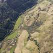
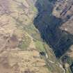
The footing of a sub-rectangular building were recorded during survey by Headland Archaeology Ltd in 1998. The building is located on the N side of the Abhainn a'Ghlinne Bhig at the SE corner of the surveyed area. The building is 11m long and 4m wide and is aligned NS to SE. It is defined by low grassy banks 1.5m wide and 0.3m high. A few stones are visible through the turf. The building is divided into a smaller room 4.5m long to the NW with a larger room 6.5m long to the SE. An entrace leads into the smaller room from the SW.
Headland Archaeology Ltd MS/899/115
Sponsor: Historic Scotland

