
Unst, Norwick, St John's Church And Churchyard


Broch (Iron Age)(Possible), Burial Ground (Period Unassigned), Church (Medieval), War Memorial (20th Century)
Site Name Unst, Norwick, St John's Church And Churchyard
Classification Broch (Iron Age)(Possible), Burial Ground (Period Unassigned), Church (Medieval), War Memorial (20th Century)
Alternative Name(s) Norwick Churchyard, War Memorial
Canmore ID 150
Site Number HP61SE 1
NGR HP 6517 1410
Datum OSGB36 - NGR
Permalink http://canmore.org.uk/site/150


- Council Shetland Islands
- Parish Unst
- Former Region Shetland Islands Area
- Former District Shetland
- Former County Shetland
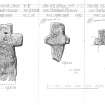
Norwick 1 (St John), Unst, Shetland, cruciform stone
Measurements: H 0.60m, W 0.36m
Stone type: schist
Place of discovery: HP 6517 1410
Present location: Shetland Museum, Lerwick (BEL 1993.449).
Evidence for discovery: recorded by RCAHMS in 1930.
Present condition: good
Description
This is a well-shaped cruciform stone with equal squared arms and an expanded shaft. There is a small pit at the base of the upper arm.
Date: ninth to eleventh centuries.
References: RCAHMS 1946, no 1536; Scott & Ritchie 2009, no 110.
Compiled by A Ritchie 2016
Norwick 2 (St John), Unst, Shetland, cruciform stone
Measurements: H 1.00m, W 0.38m
Stone type: schist
Place of discovery: HP 6517 1410
Present location: in the churchyard at Norwick.
Evidence for discovery: recorded by RCAHMS in 1930.
Present condition: good
Description
A relatively large cruciform stone, this has squared terminals to the side-arms, whereas the upper arm flares into a triangular shape and the shaft is also flared.
Date: ninth to eleventh centuries.
References: RCAHMS 1946, no 1536; Scott & Ritchie 2009, no 111.
Compiled by A ritchie 2016
Norwick 3 (St John), Unst, Shetland, cruciform stone
Measurements: H 0.82m, W 0.34m
Stone type: schist
Place of discovery: HP 6517 1410
Present location: in the churchyard at Norwick.
Evidence for discovery: recorded by RCAHMS in 1930.
Present condition: good
Description
This cruciform stone has squared terminals to the side-arms, whereas the upper arm and the shaft are flared.
Date: ninth to eleventh centuries.
References: RCAHMS 1946, no 1536; Scott & Ritchie 2009, no 112.
Compiled by A Ritchie 2016
Norwick 4 (St John), Unst, Shetland, cruciform stone
Measurements: H 0.89m, W 0.30m
Stone type: schist
Place of discovery: HP 6517 1410
Present location: in the churchyard at Norwick.
Evidence for discovery: recorded by RCAHMS in 1930.
Present condition: there is damage to one vertical side of the stone, possibly the result of deliberate trimming.
Description
The surviving side-arm id shorter than the upper arm, and the angles between the arms continue as sunken triangles towards the centre of the cross.
Date: ninth to eleventh centuries.
References: RCAHMS 1946, no 1536; Scott & Ritchie 2009, no 113.
Compiled by A Ritchie 2016
HP61SE 1 6517 1410
(HP 6516 1411) St John's Church (LB) (Site of)
OS 6" map, Shetland, 2nd ed., (1900)
The grass-grown foundations of St John's Church, Norwick, which consisted of nave and chancel (MacGibbon and Ross 1896) The north wall is slightly curved, due, according to local tradition, to its overlying the foundations of a broch.
In the churchyard are some rudely cross-shaped head- stones and coped coffins of rude construction.
D MacGibbon and T Ross 1896; RCAHMS 1946.
Only turf-covered wall footings remain of the nave. The chancel, apart from the footings of the S. wall, has been obliterated by a modern grave monument. The burial ground is still in use. No trace of a broch though the knoll on which the church and churchyard stands is big enough to have supported one.
Resurveyed at 1/2500.
Visited by OS (R L), 26 April 1969.
HP 651 140 A salvage excavation was carried out in May and June 2003 during the construction phase of an extension to Norwick churchyard. Within the churchyard are the Scheduled foundations of a Romanesque church that had been built on top of a mound, a possible broch site.
The remains of three separate house structures, together with an extensive network of stone-lined and covered drains were found in an area of about 300m2 adjacent to the churchyard wall, along with many steatite objects. Bowl fragments were circular and finely made, indicating a Viking date. Five hearths were identified, including one measuring 2.3 x 0.5m internally. Small blocks of wax were also found, and part of the base of a 20mm square wax cup. One drain had been later reused as a forge, with a pit at the lower end, and was well preserved. There was also what appeared to be the outline of a small wooden building in the sandy soil next to the pit.
An Iron Age layer was uncovered towards the end of the excavation below the Viking layer, separated by about 1m of sand. Although it was not possible to excavate this layer before it was destroyed, large amounts of burnt material containing pottery were noted, from which a fragment of a Roman fibula brooch was found.
Sponsor: Unst Archaeological Group.
L H Smith 2003.
HP 652 141 Archaeological remains previously found during a watching brief on the construction of an extension to the existing cemetery had been tentatively interpreted as a possible church with associated burials. The evaluation in April 2003 demonstrated that the features were not burials, and no evidence was found of an early church. However, the morphology of the structure and the nature of the artefactual assemblage recovered suggests that the site may relate to Norse domestic activity, together with later turf dykes of unknown date.
Report lodged with Shetland SMR and the NMRS.
Sponsor: Shetland Islands Council.
P Duffy 2003.
Publication Account (2002)
HP61 2 ST. JOHN'S CHURCH
HP/652141
Possible broch at Norwick on Unst. The north wall of the church is slightly curved because, according to local tradition, it overlies the wall of a broch.
Sources: 1. OS card HP 61 SE 1: RCAHMS 1946, vol. 3, no. 1536, 126.
E W MacKie 2002
Watching Brief (12 September 2011 - 15 September 2011)
HP 65120 14100 A watching brief was undertaken 12–15 September 2011 during ground-breaking works associated with the construction of an agricultural shed. The site was considered sensitive due to its close proximity to the scheduled remains of a Romanesque church (HP61SE 1) and a mound thought to be the site of a broch. Viking remains were also discovered during a salvage excavation in 2003 c50m to the E of the proposed development.
The excavations revealed a well preserved section of dry stone wall, which was probably part of a dyke or enclosure. Although no datable material was recovered its stratigraphic position indicated that it was possibly prehistoric in date. There were no deposits associated with the stonework that might have indicated domestic activity, occupation or soil enhancement.
Archive: RCAHMS and Shetland Museum (intended). Report: Shetland Amenity Trust
Funder: Mr David Laurenson
Rick Barton, Rick Barton Archaeological Consultancy, 2012
(Source: DES)

