
Wigtown Airfield


Tracked Target Range (20th Century)
Site Name Wigtown Airfield
Classification Tracked Target Range (20th Century)
Alternative Name(s) Baldoon Airfield
Canmore ID 149977
Site Number NX45SW 41.02
NGR NX 44572 52527
Datum OSGB36 - NGR
Permalink http://canmore.org.uk/site/149977


- Council Dumfries And Galloway
- Parish Kirkinner
- Former Region Dumfries And Galloway
- Former District Wigtown
- Former County Wigtownshire
NX45SW 41.02 44572 52527
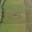
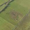
A tracked target range for training air gunners is depicted on the curent OS 1:10000 map some 500m due S of Crook of Baldoon farm.
Information from RCAHMS (DE) September 1999
The tracked target range is visible on vertical air photographs (106G/Scot/UK 42, 4212-4213, flown 4 May 1946), about 250m W from Baldoon Sands.
It is also visible on air photographs taken in 1988 (All Scotland Survey [Jasair], 24 88 053-054, flown 11 June 1988, but several of the associated buildings have been removed..
Information from RCAHMS (DE), April 2006

