|
Photographs and Off-line Digital Images |
IN 5701 |
List C Survey |
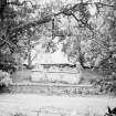
Elevated view of ruin |
1975 |
Item Level |
|
|
Manuscripts |
MS 7339/7 |
Stuart Farrell |
Report on Badenoch & Strathspey Parish Graveyard Surveys |
9/1999 |
Item Level |
|
 |
On-line Digital Images |
SC 1641778 |
List C Survey |
Elevated view of ruin |
1975 |
Item Level |
|
 |
On-line Digital Images |
SC 2367140 |
Records of the Ordnance Survey, Southampton, Hampshire, England |
St Drostan's Chapel, NH80SW 1, Ordnance Survey index card, page number 1, Recto |
1958 |
Item Level |
|
 |
On-line Digital Images |
SC 2367141 |
Records of the Ordnance Survey, Southampton, Hampshire, England |
St Drostan's Chapel, NH80SW 1, Ordnance Survey index card, page number 2, Verso |
1958 |
Item Level |
|
 |
On-line Digital Images |
SC 2367142 |
Records of the Ordnance Survey, Southampton, Hampshire, England |
St Drostan's Chapel, NH80SW 1, Ordnance Survey index card, Recto |
1958 |
Item Level |
|
|
All Other |
551 260/1/1/64/14 |
Stuart Farrell |
Photographs from St Drostan's Chapel Burial Ground Survey |
9/1999 |
Batch Level |
|
|
All Other |
551 260/1/1/81 |
Stuart Farrell |
St Drostan's Chapel |
9/1999 |
Sub-Group Level |
|
|
All Other |
551 166/1/1 |
Records of the Ordnance Survey, Southampton, Hampshire, England |
Archaeological site card index ('495' cards) |
1947 |
Sub-Group Level |
|


