
Unst, Muckle Flugga, North Unst Lighthouse


Lighthouse (19th Century)
Site Name Unst, Muckle Flugga, North Unst Lighthouse
Classification Lighthouse (19th Century)
Alternative Name(s) Muckle Flugga Lighthouse; Burra Firth; 'the Flugga'
Canmore ID 149
Site Number HP61NW 5
NGR HP 60666 19679
Datum OSGB36 - NGR
Permalink http://canmore.org.uk/site/149


- Council Shetland Islands
- Parish Unst
- Former Region Shetland Islands Area
- Former District Shetland
- Former County Shetland
HP61NW 5 60666 19679
Lighthouse [NAT]
Mast (to N, at HP 6066 1971)
Mast (to S, at HP 6063 1967)
OS (GIS) AIB, May 2006.
For associated shore station at Burrafirth, Unst (centred HP 6134 1487), see HP61SW 39.
(Location cited as HP 606 197). North Unst Lighthouse, built 1852 by engineers D and T Stevenson. A short circular tower, with rounded flat-roofed ancillary buildings, on a barren rock.
J R Hume 1977.
Name: Muckle Flugga (1854-8)
Location: N60 51 W0 53 North Sea, 1 mile N of Unst
Designed: David and Thomas Stevenson
Built: David and Thomas Stevenson, and Alan Brebner
Light first exhibited: 11 October 1854
Description: circular brick tower, painted white
Height of light above MHW: 217ft (66m)
Height of tower: 64ft (20m)
Light source and characteristics: W Gp Fl (2) ev 20 secs. 250W metal halide lamp: 281,000 cp: 22nm nominal range
Fog warning apparatus: None
Manning: unwatched (automatic since 20 March 1995), monitored from Northern Lighthouse Board HQ, Edinburgh
Temporary light operational in 1854 until permanent tower completed in 1858. The most northerly lighthouse in the British Isles
C Nicholson 1995.
This lighthouse was built in a near-inaccessible situation (on the 200ft [61m] high 'Great Precipice') on account of increased shipping around Shetland during the Crimean War. Construction started in July 1846, a temporary light being established on 11 October 1846; this was 22ft [6.7m] high with a cast iron lantern and temporary accommodation.
Following much discussion between the Northern Lighthouse Board and the Board of Trade, a proposal for a permanent lighthouse was approved in June 1855.
The tower was constructed by D and T Stevenson, over a hundred people working on site between April and November 1856. Brick construction was used for ease of transport, and the 64ft [19.5m] high tower was sunk into foundations sunk 10ft [3m] into rock. The light entered service on 1 January 1858, having cost £32,.000; it was automated in 1995.
S Krauskopf 2003.
Construction (1855 - 1 January 1858)
Permanent ligthouse completed on Muckle Flugga in 1858.
R W Munro 1979
Publication Account (2007)
Muckle Flugga Lighthouse
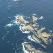
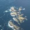
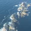
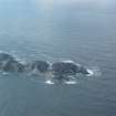
Muckle Flugga, off the north coast of Unst, Shetland, is very nearly the most northerly rock in the British Isles. As can be seen from Robert Louis Stevenson’s sketch of his uncle David and father’s project, it is a pyramid of stone rising some 200 ft above the sea. In 1853 war with Russia seemed imminent and, to safeguard a much increased naval presence near this unlit coast in this eventuality, the Admiralty commissioned the Northern Lighthouse Board to erect two lighthouses as a matter of urgency. Work had already begun at one site, Out Skerries (completed 1854), and the other site selected was Muckle Flugga. The Board’s engineers were D. & T. Stevenson.
The task of building a lighthouse at Muckle Flugga was daunting because of its remote and exposed location. In August 1854, with men using lifelines, a level platform was cut on top and a flight of rough steps hewn. Under the direction of resident engineer Alan Brebner, materials were hauled up the steps on men’s backs including the temporary iron keepers’ huts. Cement mortar was used for the first time at a rock station. Amazingly, the temporary light was lit on 11 October. It was decided to make the light permanent and the present 64 ft high lighthouse was built in brick, an untried experiment in such an exposed situation, but bricks were easier to man-handle than stone blocks. The work was carried out from 1855–57 by direct labour under D. & T. Stevenson’s direction with Brebner as resident engineer. The cost was £36 000. The workmen were housed in an iron hut and the materials needed were raised from sea level on a steep railway by means of a 10 hp steam engine. To shelter the station from storm damage, a masonry wall 5 ft high and 2 ft thick was built part way round it.
An idea of the exposure of this site can be gained from the fact that half ton stones were thrown up 80–85 ft above high water and on one occasion the protective wall round the station was thrown down and a heavy door broken at a height of 195 ft above the sea. To combat storm conditions, which they have successfully done for one and a half centuries, the tower walls were made 3 1/2 ft thick and the foundations sunk 10 ft into the rock.
Our concluding work with its tall, sea-bed anchored, framed tower, is the Murchison Oil Platform about midway between the Shetland Islands and Norway, for information on which the reader is referred to the entry at the Maritime Museum, Aberdeen.
R Paxton and J Shipway, 2007.
Reproduced from 'Civil Engineering heritage: Scotland - Highlands and Islands' with kind permission from Thomas Telford Publishers.

