
Seil Clachandubh Farm


Township (Period Unassigned)
Site Name Seil Clachandubh Farm
Classification Township (Period Unassigned)
Alternative Name(s) Kilbrandon
Canmore ID 148690
Site Number NM71NE 38
NGR NM 7630 1670
NGR Description Centred on NM 7630 1670
Datum OSGB36 - NGR
Permalink http://canmore.org.uk/site/148690


- Council Argyll And Bute
- Parish Kilbrandon And Kilchattan
- Former Region Strathclyde
- Former District Argyll And Bute
- Former County Argyll
NM71NE 38 centred on 7630 1670
see also:
NM71NE 2 NM 7633 1665 Church; Burial Ground; Chapel (possible); Sculptured Stones
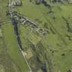
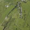
A township comprising two unroofed buildings, two partially roofed buildings, one of which is a long building, three roofed buildings, one of which is L-shaped, and five enclosures is depicted on the 1st edition of the OS 6-inch map (Argyllshire 1875, sheet cxxi). One unroofed and one roofed building are shown on the current edition of the OS 1:10000 map (1978).
Information from RCAHMS (SAH) 16 September 1998
NM 763 167 A watching brief was carried out between May and September 2000 on a water pipeline installation along the roadside and through fields beside a settlement site marked on Pont's map of c 1590. No finds of archaeological significance were made.
Report to be lodged with the NMRS.
Sponsor: West of Scotland Water.
G Mudie 2001b
Field Visit (26 April 2018)
NM 7630 1670 The following were noted as part of
Clachandubh Township (NM71NE 38) while on a visit to
Kilbrandon Graveyard (NM71NE 2) on 26 April 2018.
NM 76300 16658 Building and enclosure.
NM 76311 16678 Building.
NM 76372 16704 L-shaped building.
Archive: NRHE
Stuart Farrell
(Source: DES, Volume 19)

