
Rona, Toa Rona


Dyke(S) (Period Unassigned), Peat Stand(S) (Period Unassigned)
Site Name Rona, Toa Rona
Classification Dyke(S) (Period Unassigned), Peat Stand(S) (Period Unassigned)
Alternative Name(s) North Rona; Rona Ronaidh
Canmore ID 1475
Site Number HW83SW 4
NGR HW 8156 3226
Datum OSGB36 - NGR
Permalink http://canmore.org.uk/site/1475


- Council Western Isles
- Parish Barvas
- Former Region Western Isles Islands Area
- Former District Western Isles
- Former County Ross And Cromarty
HW83SW 4 centred 8156 3226
(HW 8147 3241 - 8135 3216
HW 8161 3239 - 8151 3224)
Mounds similar to the longer mounds of HW83SW 3, i.e up to about 16ft in length, but connected by the remains of stone built walls of unknown height, lie east of the village in the depression by Toa Rona.
There are two lines both oriented approximately NNE to SSW. "The orientating of these mounds is puzzling - one interpretation may be that a rotation of grazing was observed and that these lines served to separate the Toa from the remainder of the island. From field survey alone, however, no satisfactory explanation can be offered."
H C Nisbet and R A Gailey 1960.
These walls would seem to separate fields. The mounds appear to be the result of collapsed walls, and could have been plantie-crubs.
Information from J C Ashford (LS reviser), 7 August 1971.
Forty-one unroofed structures, thirteen of which are attached to two walls, one unroofed building (HW 8169 3228) and two other walls are depicted on the 1st edition of the OS 6-inch map (Ross-shire, Island of Lewis 1854, sheet 47). Eleven unroofed structures, four walls and an unroofed building (HW 8140 3250) are shown on the current edition of the OS 1:10000 map (1973).
Information from RCAHMS (SAH), 26 June 1997.
Field Visit (3 July 2009 - 4 July 2009)
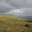
There are at least fifty mounds scattered amidst traces of peat cuttings eastwards across the lower slopes of the island between the head-dyke of the field-system (HW83SW 8) and the foot of the W flank of Tobha Ronaidh. Another thirty are strung out along the two old field-dykes that drop down the slope, the eastern tucked into the foot of Tobha Ronaidh, the western dropping from a prominent rocky outcrop in the saddle to the W. The mounds scattered across the slope are by and large undistinguished, most measuring between 2m and 3m across and no more than 0.4m in maximum height, the better defined with stones protruding across their surfaces and around their edges.
One of only a handful that lie between the two dykes is a much large structure (HW 81496 32270), comprising a long rectangular stand some 0.2m high, with a second, oval, stand set symmetrically across its centre. The rectangular stand measures 11.1m in length from NNE to SSW by 3.8m in breadth over a low kerb of boulders that barely protrudes through the turf along its sides. The second overlying stand measures 5m from NNE to SSW by 3.8m transversely overall, and has small stones visible along its sides and SSW end. While this stand is unusual, there are another three rectangular examples that are of this order of size, one overlying the eastern dyke about 30m to the SE (HW 81531 32249), and two overlying the western dyke towards the top of the slope (HW 81458 32489 & 81461 32453); overall they measure 8m by 4.2m, 7.3m by 3.9m and 12.5m by 3.8m respectively, the last apparently riding up onto an earlier stand at its S end, which forms a disturbed stony mound 5.5m in diameter by 0.5m in height.
The rest of the stands overlying the western dyke are mainly mounds with stones protruding around their edges, set on the crest of the bank; variously rectangular, oval and circular, they range in size from 2.5m to 4.6m across by up to 0.5m in height. In some cases the mound may represent the eroded stump of a stack of peats. Several of those strung along the eastern dyke are also mounds, but most are more formally constructed oval structures, measuring up 5m by 4m over kerbs of upright stones between 0.1m to 0.4m high. The kerbstones have evidently been robbed form the dyke to either side, which in some places has completely disappeared; their interiors are relatively level and seldom rise more than 0.2m above the level of the surrounding ground. In only one case (HW 81570 32327) is this relationship with the dyke possibly reversed. Here the dyke appears to ride over the SE side of a stand measuring a maximum of 4.5m in diameter over a kerb of upright stones, though the survival of the kerb unrobbed perhaps indicates that it repeats the same relationship as the other stands along its line.
The dykes themselves evidently relate to the organisation of the grazings on the island, though whether they are contemporary or successive is unknown. The eastern (HW 81614 32373 to 81521 32203) cuts straight across between the tops of two precipitous gullies, neatly separating the headland crowned by the lighthouse from the rest of the island. The remains of several other dykes can also be seen dividing up parts of the headland (HW83SW 14). The western (HW 81439 32542 & 81364 32161) follows a more sinuous course, and while at its southern end it probably ran out onto the cliff-line, at the top of the slope it simply peters out at the top of the escarpment to the NW of the prominent rock outcrop. On the SW of the of the outcrop it possibly bifurcates (HW 81465 32485) to extend a spur about 100m ESE, initially as a scarp and eventually petering out in what are probably peat-cuttings short of the cliff-edge (HW 81560 32457). On the line of this scarp on the S of the outcrop there is also a prominent platform (HW81480 32479) measuring up to 5m across, with a stony scarp around its leading edge, which is up to 1.1m high on the SSW; it is probably no more than another stand.
Visited by RCAHMS (SH, DCC) 3-4 July 2009
Measured Survey (7 July 2009)
Ian Parker (RCAHMS Surveyor) and Jill Harden surveyed this peat stand, one of large group, on 7 July 2009 at a scale of 1:100 with plane-table and alidade. The plan was drawn up in graphic vector software in 2013.

