
Gogarburn, Glasgow Road, Gogarburn Hospital, Royal Bank Of Scotland Headquarters


Hospital (Period Unassigned), Office(S) (Period Unassigned), Settlement (Medieval), War Memorial(S) (20th Century)
Site Name Gogarburn, Glasgow Road, Gogarburn Hospital, Royal Bank Of Scotland Headquarters
Classification Hospital (Period Unassigned), Office(S) (Period Unassigned), Settlement (Medieval), War Memorial(S) (20th Century)
Alternative Name(s) Gogarburn Institution; Gogarburn House; Asylum; Home For Mental Defectives; Royal Bank Of Scotland Headquarters; War Memorials
Canmore ID 145849
Site Number NT17SE 145
NGR NT 1670 7220
NGR Description Centred NT 1670 7220
Datum OSGB36 - NGR
Permalink http://canmore.org.uk/site/145849


First 100 images shown. See the Collections panel (below) for a link to all digital images.
- Council Edinburgh, City Of
- Parish Edinburgh (Edinburgh, City Of)
- Former Region Lothian
- Former District City Of Edinburgh
- Former County Midlothian
NT17SE 145.00 centred 1670 7220
NT17SE 145.01 16441 72043 Gogarburn House
An extensive programme of archaeological work was undertaken in connection with the development of the former Gogarburn Hospital (NT17SE 145) and surrounding area. This comprised evaluation, excavation, watching briefs and historic building recording.
NT 168 725 Nether Gogar. The most substantial part of this work was the excavation of part of the medieval settlement of Nether Gogar. The location and extent of the medieval features were determined during an evaluation in 2002.
Topsoil removal revealed a number of ditches and pits concentrated on the flat plateau at the SE corner of the site. Pottery found within the ditches and pits has been dated mainly to the 12th to 15th centuries. The features are thought to represent the truncated remains of domestic and agricultural activity associated with Nether Gogar.
Four further trenches were excavated through the truncated remains of a post-medieval mill lade, first identified during the evaluation of the site.
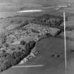
NT 165 721 Gogarburn Hospital. The site of Gogarburn Hospital was initially evaluated and, although no archaeologically significant features were present, potential areas of archaeological survival were identified. A photographic record was made of the existing hospital buildings prior to their demolition. A watching brief followed during the demolition of the old hospital and all other groundbreaking works on the site. Several isolated features were uncovered, including a number of medieval features, mainly rig and furrow, containing pottery contemporary with the settlement at Nether Gogar. A large undated ditch was recorded, perhaps associated with water management. Other features uncovered appeared to be landscaping features associated with Gogarburn House.
NT 172 723 Gogar Park House. A watching brief was maintained during topsoil stripping in the grounds of Gogar Park House. Stripping was limited to topsoil, and an underlying soil horizon restricted archaeological visibility across much of the monitored area. Where the overburden was sufficiently removed, the cultural features exposed were limited to field drains and the remnants of rig and furrow.
NT 168 725 196-198 Glasgow Road. Further building recording was undertaken at 196-198 Glasgow Road prior to demolition. They appear to have been purpose built as a blacksmith's and a carpenter's shop respectively, and are marked as such on a map of 1830.
Reports to be lodged with Edinburgh SMR and the NMRS.
Sponsor: Royal Bank of Scotland Group.
Edinburgh, Gogarburn Institution.
S.N.B.R - 1 Newspaper cutting.
Missing at time of upgrade.
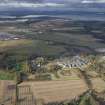
The world headquarters for the Royal Bank of Scotland at Gogarburn has been recorded under construction on oblique aerial photographs (RCAHMSAP 2003). The complex was designed by Michael Laird Architects and occupies a 78 acre site. Construction began in 2002.
Information from RCAHMS (MMB) 15 April 2004

