
Sheriff Muir


Depot (20th Century), Tramway (20th Century)
Site Name Sheriff Muir
Classification Depot (20th Century), Tramway (20th Century)
Alternative Name(s) Whitestone Range; Black Hill; Sheriffmuir
Canmore ID 145654
Site Number NN80SW 23.05
NGR NN 8405 0405
Datum OSGB36 - NGR
Permalink http://canmore.org.uk/site/145654


- Council Stirling
- Parish Dunblane And Lecropt
- Former Region Central
- Former District Stirling
- Former County Perthshire
Field Visit (27 November 1998)
NN80SW 23.05 8405 0405
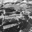
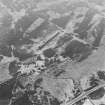
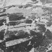
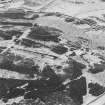
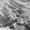
What may have been the line of a tram, or trolley way, lies to the rear, or SE, of the Atlantic wall (NN80SW 23.01), in amongst a confusing network of earlier trackways (NN80SW 23.06). It runs from an area of disturbed ground beside the public road, near Harperstone Farm, and does not appear to extend beyond the wall. The disturbed ground may have been the 'depot' for handling building materials primarily for the Atlantic wall. Access to the depot appears to have been through a gap in the collapsed drystone wall that runs along the NE side of the public road. There is a large shuttered concrete block beside this entrance, attached to which there may have been a lifting barrier. A concrete floor to the NE of the entrance may have supported a small building. The line of the tramway must have been carried across Geordie?s Burn, perhaps on a timber bridge, avoiding the slight incline and boggy ground between the wall and the road, which would otherwise provide the shortest access.
Visited by RCAHMS (DCC), 27 November 1998.

