
North Cuil


Building (Period Unassigned)
Site Name North Cuil
Classification Building (Period Unassigned)
Canmore ID 145230
Site Number NM95NE 10
NGR NM 9786 5531
Datum OSGB36 - NGR
Permalink http://canmore.org.uk/site/145230

- Council Highland
- Parish Lismore And Appin (Lochaber)
- Former Region Highland
- Former District Lochaber
- Former County Argyll
NM95NE 10 9786 5531
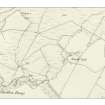
One unroofed building is depicted on the 1st edition of the OS 6-inch map (Argyllshire 1875, sheet xliii), but it is not shown on the current edition of the OS 1:10000 map (1976).
Information from RCAHMS (SAH) 13 May 1998
Reference (1 February 2009 - 1 March 2009)
Old maps and photographs.
Field Visit (1 February 2009 - 1 March 2009)
Walking the site.
Srp Note (7 February 2011)
Bedford's Marine Chart (1861)shows a building here. Nearby are the words "Salmon Fishery" which suggests that this building was involved in this activity. The 1st edition of the OS 6-inch map (Argyllshire and Buteshire 1875, sheet xliii)map shows an unroofed building at this location. It cannot be detected in one of Erskine Beveridge's photographs of 1883 and had presumably fallen into disrepair by that time. Nothing is now visible and it stood in a field that was ploughed for many years.

