
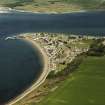
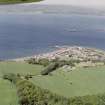
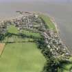
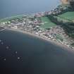
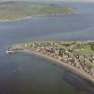
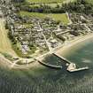
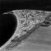
Cromarty, Marine Terrace, The Harbour


Harbour (18th Century)
Site Name Cromarty, Marine Terrace, The Harbour
Classification Harbour (18th Century)
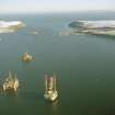
Alternative Name(s) Cromarty Harbour; Cromarty Defences; Cromarty Firth; Firth Of Cromarty; Cromarty Bay
Canmore ID 14473
Site Number NH76NE 49
NGR NH 78540 67723
NGR Description Centred NH 78540 66723
Datum OSGB36 - NGR
Permalink http://canmore.org.uk/site/14473


- Council Highland
- Parish Cromarty
- Former Region Highland
- Former District Ross And Cromarty
- Former County Ross And Cromarty
NH76NE 49 centred 78540 66723
Harbour [NAT]
Pier [NAT] (at NH 7855 6778)
Pier [NAT] (at NH 7847 6775)
OS 1:10,000 map, 1983.
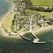
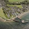
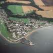
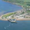
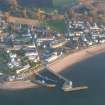
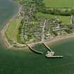
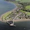
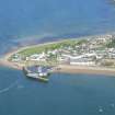
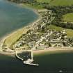
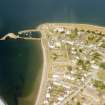
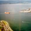
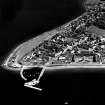
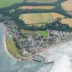
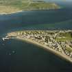
An enclosed harbour formed by two masonry piers jutting W into Cromarty bay. The southern pier has a wooden extension which forms a 'T'. Built c.1875
EXTERNAL REFERENCE
Scottish Records Office
Proposal to use the Harbour of the Bay of Cromarty as a naval station.
Sketch and plan of the entrance to the Bay. It accompanies a letter from Lt. Col. Innes Munro.
1795 GD 51/2/40/2
(Undated) information in NMRS.
(Location cited as NH 786 678). Cromarty Harbour, built c. 1785. A simple harbour of enclosure formed by two masonry piers, one with a wooden extension which forms a T.
J R Hume 1977.
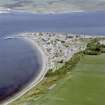
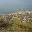
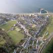
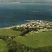
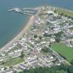
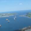
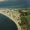
(Location cited as NH 866 677). Cromarty. Records relating to an early harbour at Cromarty are difficult to interpret with confidence as they are apt to confound the firth itself with artificial works at the town. This is certainly true of Bishop Leslie's account (cited by Brown), of a document of the early 17th century (cited by Macfarlane), which rates the firth as safe, capacious, free of sands and shallows and providing a good bottom for anchoring (omnes denique egregii portus laudes habet); and of the Statistical Account, with its allusion to an anchorage in the shelters of the Sutors; and of the New Statistical Account. In earlier days, the firth was called Portus Salutis, and is marked as Portus Securus on Bishop Leslie's map. On the other hand, the reference of 1592 to regulations for the 'heaven and port of Cromarty' suggests an organised sea-port rather than a mere roadstead or sheltered anchorage, while the chart in Collin's Pilot (1776) is ambiguous. Ambiguity ceases, however, with the positive statement that a 'most commodious quay' was built in 1785 jointly by the proprietor, George Ross, and the government; this accommodated vessels of up to 350 tons and served a ferry crossing the narrows of the firth. A plan surveyed in 1893 shows two parallel E-W piers, and a freestanding breakwater to the W of the entrance.
Structure. Apparently consistent red stone block construction characterises the present N pier, 300ft (91.2m) long and 20ft (6.1m) wide, the shore quay, 220ft (66.9m) long and 30ft (9.1m) wide, the S pier, 200ft (61m) long and 30ft (9.1m) wide, and the freestanding breakwater in the harbour mouth, now joined to the S pier by a bridge and extended to form a deep water quay. There is a string course all the way along the curved outer side of the N pier, which otherwise rises uninterrupted to the summit of the parapet wall. This ends in a small turret, where a light would have been useful. Steps are inset in the inner pier face, just below the turret. One wooden pawl survives near the head of these steps. There is another set of steps, descending seawards, contrary to the direction of those just mentioned, inset in the face about halfway to the shore. Still nearer the shore quay, an arched opening in the pier has been blocked with matching stonework. A third set of steps is in the quay face, at its angle with the N pier. A slip rises from the beach for 65ft (19.7m) alongside the S end of the quay, which curves back a little at this point, perhaps to facilitate haulage to the level at which it meets the S pier. The whole design is elegant, and indicates, in addition, an intention to assist the working of small craft in rough weather.
A Graham and J Gordon 1988.
Harbour, Marine Terrace. Begun in 1875 with two piers built of rough ashlar. The S pier was extended with an iron bridge to a wooden landing stage by James Fraser, 1880.
J Gifford 1992.
Cromarty Harbour was modified during World War II for military purposes. The concrete piers are still visible today.
J Guy 2000; NMRS MS 810/10, Vol. 2, 103.
Harbour
2nd Millennium AD.
Stable condition.
CFA/MORA Coastal Assessment Survey 1998.
Build (1781 - 1785)
Built 1781-1785. Designed by John Smeaton. North Pier completed by 1783.
R Paxton and J Shipway, 2007.
Publication Account (2007)
Cromarty Harbour
(Institute Civil Engineers Historic Engineering Works no. HEW 2547)
The earliest piers of the present harbour were designed by John Smeaton, who is known to have taken his own levels during site investigation. Work probably began in 1781 and by 1785 a ‘most commodious quay’ had been provided jointly by the proprietor, George Ross, and the government,
under the superintendence of John Gwyn as resident engineer.
By 1783 the curving 230 ft long north pier had been built in typical Smeaton construction, using small squared blocks of reddish sandstone. Smeaton then decided to terminate it and construct a detached pier, or breakwater, 130 ft long almost parallel to the shore and about 70 ft from the north pier head. He considered that this arrangement would provide adequate protection for shipping without too much deposition of sand within the harbour. By 1839 a south pier had been built and in ca.1994 a timber structure connecting it with the breakwater was replaced by the present Bailey bridge.
R Paxton and J Shipway, 2007.
Reproduced from 'Civil Engineering heritage: Scotland - Highlands and Islands' with kind permission from Thomas Telford Publisher

