
Nigg Ferry, Royal Navy Pier


Pier (First World War), Pier (20th Century), Pier (Second World War)
Site Name Nigg Ferry, Royal Navy Pier
Classification Pier (First World War), Pier (20th Century), Pier (Second World War)
Alternative Name(s) Submarine Mining Depot, Pier; Cromarty Firth; Firth Of Cromarty; Cromarty Defences
Canmore ID 14469
Site Number NH76NE 45
NGR NH 79610 68690
Datum OSGB36 - NGR
Permalink http://canmore.org.uk/site/14469


- Council Highland
- Parish Nigg (Ross And Cromarty)
- Former Region Highland
- Former District Ross And Cromarty
- Former County Ross And Cromarty
NH76NE 45.00 79610 68690
Pier [NAT]
OS (GIS) MasterMap, May 2010.
NH76NE 45.01 NH 7960 6869 Military Installation
A straight wooden pier supported by wooden cross-braced piles.
(Undated) information in NMRS.
Pier and slipway.
CFA/MORA Coastal Assessment Survey 1998.
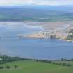
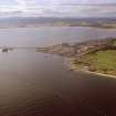
The former Royal Navy pier for the Submarine Mining Depot at Nigg Ferry is situated immediately W of the slipway for the summer only ferry to Cromarty.
The pier is now derelict and fenced off as it is in a dangerous condition. Two modern portakabins now stand on the pierhead.
Constructed mainly of wood with a pierhead it measures about 89m in length. The pier is supported on wooden piles.
The remains of a tramway which ran from the Submarine Mining Depot shed about113m to the N (NH76NE 291), were noted at the N end of the pier.
Visited by RCAHMS (DE, AL), 9 February 2010.

