
Myreton Hill


Enclosure(S) (Post Medieval), Farmstead (Post Medieval), Field System (Post Medieval), Track (Post Medieval)
Site Name Myreton Hill
Classification Enclosure(S) (Post Medieval), Farmstead (Post Medieval), Field System (Post Medieval), Track (Post Medieval)
Canmore ID 144322
Site Number NS89NE 111
NGR NS 8527 9807
NGR Description centred on NS 8527 9807
Datum OSGB36 - NGR
Permalink http://canmore.org.uk/site/144322


- Council Clackmannan
- Parish Alva
- Former Region Central
- Former District Clackmannan
- Former County Clackmannanshire
Field Visit (24 April 1997)
NS89NE 111 centred on NS 8527 9807
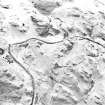
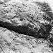
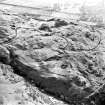
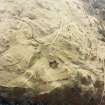
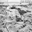
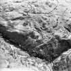
A farmstead and field-system are situated on a broad grass-covered terrace on the W flank of Myreton Hill. The farmstead comprises a rectangular building and two abutting enclosures. The building (MENS97 27) measures 7.9m from ESE to WNW by 3.3m transversely within a robbed stony bank spread to 0.9m in thickness and 0.3m in height. The entrance is in the WNW end. A bank, probably a head-dyke, abuts the enclosures and extends to the First Inchna Burn on the NNE and for some 30m to the SSW before being slighted by later cultivation. Further field banks to the S of the farmstead (NS 8527 9796) define at least four fields which measure between 60m by 40m and 120m by 60m across, enclosing both flat and broken ground, and containing some rig. There is some evidence of phasing in the field banks, in particular the smallest field (NS 8531 9798) which is overlain by a much larger enclosure. Another plot lies on the hillside to the NE of the farmstead (NS 8542 9815), but this does not appear to contain any rig. Patches of unenclosed rig (e.g. NS 8518 9778) cover the flatter ground between rock outcrops around the farmstead.
A trackway, flanked by the head-dyke described above and a second bank, leads from the farmstead to the First Inchna Burn and may continue up the hillside to the N of the burn (see NS89NE 108). The bank on the E side of the trackway turns up the hill to the S of the burn and together with the bank which encloses Myreton Hill (NS89NE 48) may have formed a driftway to funnel cattle along the trackway and prevent access to cultivated ground. Fragmentary banks run along the S side of the gorge of the First Inchna Burn, mostly marking the edges of cultivated ground.
In dead ground within the field-system, there are three earthen-banked enclosures measuring about 10m across (NS 8518 9798; 8519 9799; 8512 9776).
(MENS97 27)
Visited by RCAHMS (DCC) 24 April 1997

