
Loch Of Liff


Cursus (Neolithic)
Site Name Loch Of Liff
Classification Cursus (Neolithic)
Canmore ID 143302
Site Number NO33SW 83
NGR NO 33330 33936
Datum OSGB36 - NGR
Permalink http://canmore.org.uk/site/143302


- Council Angus
- Parish Liff And Benvie (Angus)
- Former Region Tayside
- Former District City Of Dundee
- Former County Angus
NO33SW 83 33330 33936
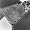
Oblique aerial photographs (RCAHMSAP 1995) show the cropmarks of a possible cursus with two parallel linear cropmarks, aligned NW-SE, immediately to the N of Loch of Liff farmsteading. The cursus can be traced for a distance of approximately 150m (NO c.3326 3396 to NO c.3340 3391), and it has a width of about 25m. No terminals are visible.
Information from RCAHMS (KJ) 6 April 1999.

