
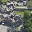
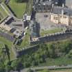
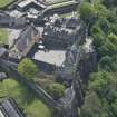
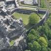
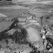
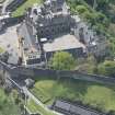
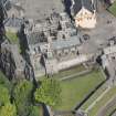
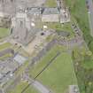
Stirling Castle, Outer Defences


Battery (18th Century), Gate (Period Unassigned)
Site Name Stirling Castle, Outer Defences
Classification Battery (18th Century), Gate (Period Unassigned)
Alternative Name(s) Spur Battery; Queen Anne Battery; Over Port Battery; New Port
Canmore ID 142579
Site Number NS79SE 6.07
NGR NS 79068 94007
Datum OSGB36 - NGR
Permalink http://canmore.org.uk/site/142579


- Council Stirling
- Parish Stirling
- Former Region Central
- Former District Stirling
- Former County Stirlingshire
NS79SE 6.07 7906 9401
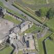
NS 790 940 A watching brief was maintained in August during the excavation of a pipe trench through the E gateway of the protective wall surrounding the Nether Bailey powder magazines.
The excavation consisted of a meandering trench 9m long with an average depth of 500mm. The trench cut through areas of granite setts and sandstone paving, the setts forming the surface of the roadway which runs E-W through the Nether Bailey, while the sandstone paving forms the surface of a footpath created by the 2.5m gap between the magazines and their protective perimeter wall.
It seems clear that the area around the sides of the magazines has seen considerable disturbance over the years. Removal of the sandstone paving from the pathway around the immediate base of the magazine walls exposed a concrete foundation layer which, when removed, revealed a layer of black-brown soil in which numerous disturbed cobble stones could be seen. This appears to be the remnants of an earlier cobbled surface destroyed by later construction work and thrown back as landscaping to underlie the new sandstone paving slabs. Below this, the clay which overlay the basalt masonry seems to be an original waterproofing layer placed over the buried top of the magazine founds in order to direct moisture away from the powder magazine stonework.
In general terms, the new sandstone paving seems fairly recent and most of the disturbances appear to have taken place over a period probably not exceeding the last 50 years or so.
Sponsor: Historic Scotland
D Stewart 2000
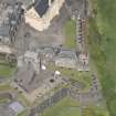
Kirkdale Archaeology carried out a series of excavations in the western areas of Stirling Castle, centred around an area known as 'Ladies Lookout'. Deep deposits of dumped and naturally accumulated layers were uncovered, a selection of which were sent to CFA Archaeology for analysis. The layers were found to contain pottery fragments, glass, animal bone, cereal remains, plant material, wood charcoal, coal and cinders.
M Hastie 2006
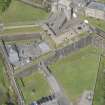
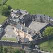
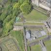
NS 790 940 A watching brief was required in May 2003 for minor excavations on the upper gun platform of the French Spur at Stirling Castle. It was noted that the top surface of the French Spur has been very extensively excavated over the years and that the upper deposits in this area are likely to be landscaped backfill. There were no finds of archaeological significance.
Archive to be deposited in the NMRS.
Sponsor: HS
G Ewart 2003
NS 7902 9414 In the wall on the N side of the southernmost spur in the W wall of the N bailey of the castle, immediately N of the North Gate, are a least six blocks of roughly dressed stone. These are of Carboniferous Millstone grit, unlike the irregular blocks of lava agglomerate that form most of the wall. Three of these are extremely large, 1.48 x 0.3m and 1.57m long x 0.37m wide and 1.45 x 0.3 x 0.57m thick. The others were 0.42 x 0.36 x 0.21m, 0.65 x 0.36 x 0.26m and 0.62 x 0.36 x 0.25m.
Chistopher A Kelly, 2006.
Excavation (1977)
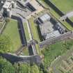
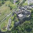
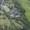
NS 790940 In advance of cable-laying across the Counterguard, W of the gate-house and outer ditch, three trenches were excavated. The largest of these was to the N and W of the junction of the outer 18th
century rampart and the Spur Battery. This revealed part of the Spur (rampart and walkway constructed in the 16th or 17th centuries) which
followed virtually the same alignment as the existing 18th century rampart. This trench also brought to light three secondary walls which appear to predate the Spur. An important group of Medieval and Post-Medieval pottery was retrieved from the backfill connected with the construction of the 18th century Spur Battery. A second trench, against the N wall of the outer ditch, was fruitless.
The last trench, to the E of the junction of the Spur Battery and the outer 18th century rampart in the outer ditch, revealed a substantial amount of modern redeposited levelling material.
G J Ewart 1977
Kirkdale Archaeology
Excavation (February 1978 - October 1978)
NS 790940 Prior to completion of pipe and cable laying across the
access road North of the Overport Battery to a point within the
Queen Anne Gardens four trial trenches were sunk. The first two
trenches yielded largely 18th century material, sealing a series of
earlier tipped deposits. A further two trenches in the vicinity of
the Queen Anne Gardens;- one brought a short stretch of probable
16th century wall foundation to light and the other an 18th century
garden wall and associated cobbled surface.
A fifth area was excavated to the North of the existing flanker
chamber and most of the earlier 16th century flanker wall was exposed,
thus confirming the findings of the earlier phase of excavations
in this area.
C Tabraham 1978
Sponsor: SDD (AM)
Kirkdale Archaeology
Excavation (6 December 1992 - 29 January 1993)
Additional excavations were carried out by Kirkdale Archaeology on the Outer Defences in the winter of 1992/1993, following a series of earlier excavations carried out in spring of 1992.
G Ewart 1993
Sponsor: Historic Scotland
Kirkdale Archaeology
Excavation (6 January 1992 - 13 March 1992)
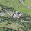
A programme of fieldwork was concentrated on two areas of the post-medieval defences of the castle in advance of prposed development. Area 1: The Interior of a building variously described as the Cart Shed or Straw Store. Area 2: An extensive area in front of the main 16th century facade and N of the Queen Anne casemates.
Area 1: Excavation Report
After the concrete floor from the interior of the Cart Shed was lifted, a series of soft earth deposits were ultimately removed down to bedrock over most of the area. The finished levels were specified by the required depth from architects' plan, so wherever that level was reached, excavation stopped. The broad phases of activity in this trench can be summarised as: Phase 1: Two apparently independent routes up to castle rock cut in bedrock. Phase 2: Defensive ditch and roadway wall built. Phase 3: Timber building constructed over infilled phase 2 wall and ditch. Phase 4: Straw Store/Cart Shed built. Phase 5: Cart Shed converted by demolition of N wall.
Phase 1
The Castle rock itself is a tightly jointed doleritic sill with pronounced regular bedding planes. Where exposed in Area 1, the bedrock surface showed signs of much weathering and wear (much more pronounced than the bedrock found in Area 2) and apart from efforts to prize sections of the sill apart to create space for Phase 3 timbers, showed sign of particular wear in 2 areas. To the SW of Area 1 two lines of 'wear' apparently evidence of vehicular traffic, were picked up, running down towards the SW. This roadway showed signs of having been levelled up and repaired with mortar rubble, resulting in a full width of 1.6m. Part of an arguably earlier trackway was picked up towards the N of Area1. This took the form of a pronounced gully or rut worn into bedrock, truncated by later ditch and associated wall F.040 and which may well be the southern side of a road, predating the ditch and wall construction of Phase 2.
Phase 2 c 1550-c1670
The S route was retained as main access to the Castle during the period of the pre-Queen Anne rebuilding programme. The creation of the French Spur saw the excavation of a deep ditch to the SE and protecting the main entrance route. Part of the ditch appeared at the NW corner of Area 1, underlying part of the N wall of the Cart Shed. It was cut against bedrock but may well be an enhancement of a natural outcropping. The ditch was tested to a depth of 2m and was not bottomed. A light mortar bonded wall lat across the southern side of the ditch - built directly onto the bedrock. This wall (F.040) was poorly preserved but proved to be 500mm wide and despite being truncated by the N wall of the Cart Shed, ran for a distance of 4.8m.
Phase 3.
The Phase 2 wall was demolished and levelled down to 2 or 3 courses, and its associated ditch was infilled with an homogeneous dump of dark earth and stones. The area was generally levelled up to receive a series of timber pads and post holes, reflecting at least one long wall of a timber building aligned E/W. There were in total 3 positive post holes (F.032, 023, 012) with one possible (F.024) with 2 pads (F.025 and 016). The settings were formed from the rubble infill of a series of crudely excavted areas on the bedrock, following the approximate line of the N edge of the Phase 2 trackway. The post settings were essentially squared voids 200mm by 200mm, and 1.5m apart. There was a possible entrance towards the W edge of the line, between the posts F.025 and F.012, defined by a door post stone (F.019). The role of pads F.025 and more enigmatically F.016 is not clear, and it
may be that the timber settings reflect enclosures rather than roofed structures. In any event, it seems that the Phase 3 timbers were temporary precursors to the Straw Store/Cart Shed which was in place by 1860.
Phase 4
The foundations for the Cart Shed walls were cut against the accumulated floor/occupation surfaces from Phase 3 activity, set within irregular foundation trenches, which varied in width from 150mm to 300mm. The depth of the distinctive shaped foundations also varied- deepening considerably to hit towards the SE, a depth of 1.2m. Once a level footing for the faced masonry was in situ, the floor was laid, characterised by mortar spreads (recycled builders' debris). Then the walls were raised to full height, with an apparent door towards the W end of the N wall. This was reflected by a distinctive recess in the S face of the N wall at this point and an equivalent projection of the N face. This does not admittedly concur with the 1860 plan which shows a centrally placed door in the N wall but no signs of such were revealed in the excavation due to damage in Phase 3.
Phase 5
The present open N wall with squared ashlar pillar was formed by the demolition of the Phase 4 N wall to virtually foundation level and the raising of floor and immediate exterior surfaces by 300mm. This was ultimately concreted over and saw use as a 'garage'.
Conclusion
The significance of the excavation in this area can be summarised as: (1) The identification of late medieval access to the castle truncated by 16th century works. (2) The presence of temporary wooden structures predating mid 19th century cart shed/straw store.
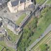
Area 2: Excavation Report
The earliest feature revealed on the site was a cut in the granite bedrock in the NW corner of the trench. The natural cleavage of the rock had been exploited to exaggerate a natural drop or, possibly, in order to create a ditch. The line of the feature respected the early 16th century castle frontage and may be a defensive feature associated with this, or perhaps an earlier phase if this is a raised position.
The excavations uncovered a length of the wall built during the regency of Mary of Guise c1559 (shown on Slezer's 17th century plan). This ran S from the section excavated in the late 1970's.
Presumably there must have been a certain amount of landfill between this wall and the early 16th century frontage, but these deposits were not reached before the required depth of excavation.
The Mary of Guise wall was used as the foundation for the battery defences built between 1708 and 1714 during the reign of Queen Anne. It seems likely that the battery wall and casemates were built almost free standing - certainly no foundation trenches were noted. The ramp wall leading down into the area was also built in this phase. Once the lower courses of these structures were laid, material was dumped against them to secure them and to raise the level of the area in general.
The original base levels of the ramp and casemate walls was indicated by the quoins uncovered reflecting a ground surface approximately 1.5m below that of the modern one.
On the 1725 plan of Stirling, the ramp wall is not shown, although the structural details are exactly the same as those of the casemate corners. However this plan shows the battery wall and the casemate extending further than they do today. There is evidence for this on the site - although not for a 2-floor barrack. A well-constructed mortared square plinth F127 was found which was inline with the casemate frontage and exactly the width of an arch from the surviving casemates. The lack of demolished wall, signs of bonding to the battery wall or remnants of vaulting suggests that the end structure was for a different purpose - possibly an outhouse for large pieces of equipment such as artillery or carts.
It is not known for how long the Queen Anne battery and casemates were used in their original form, but at some point (or points) before 1860 the layout of the area radically changed. The end casemate was demolished and the ramp wall was foreshortened. A long subdivided lean-to (three foundation piles for which were excavated) was placed against the early 16th century castle frontage and another built where the end casemate stood. The whole ground level for the area was raised by approximately 1m including within the casemates. The ramp down into the area was raised and formed by the considerable dumping of rubble given a smoother surface by the use of mortar. Cobbles/sets may also have been used over this.
However, by the late 1860's the lean-to against the 16th century frontage had been demolished, the casemates were contractors stores and the lean-to on the site of the demolished end casemate was used as an engine house. This structure was used until 1991 when it was demolished. The access routes and general ground levels in the area remained much the same as in the 19th century, the only real changes being the laying of electricity and telephone cables and the late 1970's excavations.
Thus, despite the slightly unpromising nature of the area to then be excavated, features dating from the late-medieval period onwards were uncovered, the history of the use of the Mary of Guise and Queen Anne period defences elucidated the survival of early 18th century deposits (and their contents) confirmed.
G Ewart 1992
Sponsor: Historic Scotland
Kirkdale Archaeology
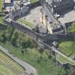
Excavation (5 October 1992 - 23 October 1992)
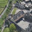
In October 1992, a twelve-day watching brief was held at Stirling Castle in the area of the eastern Counterguard, further to the excavations conducted in the same area earlier in the year. The various holes against the ramp wall and in the casemates of the Overport Battery indicated that the area had been subject to a massive programme of landfilling during the construction of the Queen Anne defences. Further N, the digging of a pipe trench revealed two retaining walls, probably of a similar date to the landfilling. A stone-lined well, filled in the early 1700s, was revealed against the Mary of Guise wall constructed in the mid-16th century upon which the Overport Battery was built. Much Scottish green glazed pottery was recovered, as well as fragments of bottle glass and clay pipe.
G Ewart 1992
Sponsor: Historic Scotland
Kirkdale Archaeology
Excavation (2 March 1993 - 7 May 1993)
NS 790 940 A series of small-scale excavations and watching briefs were completed between March and May 1993 as part of the major ongoing programme of rebuilding and upgrading at the Castle. The results of this most recent fieldwork can be summarised in terms of the four areas of the Castle effected.
1. The Overport Battery Casemates and Trance (part of the new restaurant development)
During the removal of 19th and 20th-century levelling deposits. A remnant of a defensive line, predating the Queen Anne works, was discovered in Casemate 1
2. Guard Room Square
Beneath elements of the southern Queen Anne defences, slight evidence of the earlier southern access route on to the site was traced in the form of worn and weathered bedrock.
3. The Lower Square
During the excavation of a series of pipe and service trenches, water conduits - both for drainage and water supply, were found, the earliest of which dated to the Queen Anne rebuilding programme. Also, some crude stonework with associated midden deposits, were discovered towards the SE of the Great Hall. These features are provisionally dated to the late 15th/early 16th century and represent levelling up, whether casual or deliberate, over the steeply shelving bedrock to the E of the Great Hall, down to the
North Gate.
4. The Queen Anne Battery Casemates
The interiors of four of these chambers were cleared of 19th and 20th-century infill, down to primary (early 18th century) occupation levels. Evidence of wooden floors and large squared hearths in each was found, all of which were later obscured by the raising of the floors throughout the range towards the middle of the 19th century.
G Ewart
Sponsor: Historic Scotland
Kirkdale Archaeology
Excavation (4 October 1993 - 29 October 1993)
A series of excavations were carried out by Kirkdale Archaeology in October 1993. Extensive excavations took place on the West side of the Great Hall, including the area of the Upper Square and Transe. These excavations reaveled evidence for an structure, possibly a Chapel.
Excavations were also carried out in advance of a services being laid in the area to the Northwest of the Casemates in the Queen Anne Garden.
G Ewart 1993
Sponsor: Historic Scotland
Kirkdale Archaeology
Watching Brief (19 May 2003)
NS 790 940 A watching brief was required in May 2003 for minor excavations on the upper gun platform of the French Spur at Stirling Castle. It was noted that the top surface of the French Spur has been very extensively excavated over the years and that the upper deposits in this area are likely to be landscaped backfill. There were no finds of archaeological significance.
G Ewart 2003
Sponsor: Historic Scotland
Kirkdale Archaeology
OASIS ID: kirkdale1-504951
Watching Brief (16 December 2015)
A watching brief was carried out, 16 December 2015, during the excavation of a shallow (c200mm) trench to allow the installation of a new handrail at the lower level of the French Spur.
Nothing of particular interest was found during these works although the required depth of excavation was minimal. The area is interesting as there are at least two clearly defined periods of building and remodelling, and it is clear that later remedial works have also been carried out. As the area is defined as being of high archaeological potential, it is recommended that future works be similarly accompanied by an archaeological watching brief.
It was also noted during the works that the French Spur carries an armorial on its external eastern corner, just above the lower buttressing. The stone is broken in its lower portion (possibly due to the insertion of the buttress). The armorial consists of a central fleur-de-lis flanked in its upper portion by two cinquefoils (flowers with five petals). It could be that this is a conjoining of the fleur-de-lis of Mary of Guise with the two upper and single lower (now missing) cinquefoils of the Hamiltons. Mary of Guise’s master of works from 1543 – 79 was John Hamilton of Millburn, and he would have been responsible for the construction of the French Spur.
Sponsor: Historic Environment Scotland
Paul Fox 2015
Kirkdale Archaeology
OASIS ID: kirkdale1-280336

