 |
On-line Digital Images |
SC 1696007 |
RCAHMS Aerial Photography |
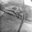
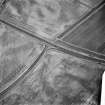
Newton and Upper Cullernie, oblique aerial view, taken from the SE, centred on the cropmarks of a barrow. A ring-ditch is visible as a cropmark in the top centre of the photograph. |
16/7/1996 |
Item Level |
|
 |
On-line Digital Images |
SC 1696008 |
RCAHMS Aerial Photography |
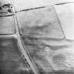
Newton and Upper Cullernie, oblique aerial view, taken from the SSE, centred on the cropmarks of a barrow. |
16/7/1996 |
Item Level |
|
 |
On-line Digital Images |
SC 1696009 |
RCAHMS Aerial Photography |
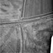
Newton and Upper Cullernie, oblique aerial view, taken from the NE, centred on the cropmarks of a barrow. |
16/7/1996 |
Item Level |
|
 |
On-line Digital Images |
SC 1696067 |
RCAHMS Aerial Photography |
Oblique aerial view. |
1981 |
Item Level |
|
 |
On-line Digital Images |
SC 1696068 |
RCAHMS Aerial Photography |
Oblique aerial view. |
1981 |
Item Level |
|
 |
On-line Digital Images |
SC 2365809 |
Records of the Ordnance Survey, Southampton, Hampshire, England |
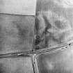
Upper Cullernie, NH74NW 47, Ordnance Survey index card, Recto |
1958 |
Item Level |
|


