 |
On-line Digital Images |
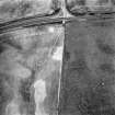
SC 1695990 |
RCAHMS Aerial Photography |
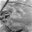
Upper Cullernie, oblique aerial view, taken from the SW, centred on the cropmark of an enclosure. A ring-ditch is visible in the top left-hand corner of the photograph. |
10/8/1995 |
Item Level |
|
 |
On-line Digital Images |
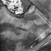
SC 1695991 |
RCAHMS Aerial Photography |
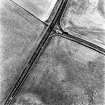
Upper Cullernie, oblique aerial view, taken from the SW, centred on the cropmark of a ring-ditch. |
10/8/1995 |
Item Level |
|
 |
On-line Digital Images |
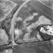
SC 1695992 |
RCAHMS Aerial Photography |
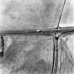
Upper Cullernie, oblique aerial view, taken from the SE, centred on the cropmark of a ring-ditch. |
10/8/1995 |
Item Level |
|
 |
On-line Digital Images |
SC 1696058 |
RCAHMS Aerial Photography |
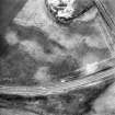
Oblique aerial view. |
1978 |
Item Level |
|
 |
On-line Digital Images |
SC 1696059 |
RCAHMS Aerial Photography |
Oblique aerial view. |
1978 |
Item Level |
|
 |
On-line Digital Images |
SC 1696061 |
RCAHMS Aerial Photography |
Oblique aerial view. |
1978 |
Item Level |
|
 |
On-line Digital Images |
SC 1696062 |
RCAHMS Aerial Photography |
Oblique aerial view. |
1978 |
Item Level |
|
 |
On-line Digital Images |
SC 2365790 |
Records of the Ordnance Survey, Southampton, Hampshire, England |
Upper Cullernie, NH74NW 35, Ordnance Survey index card, page number 1, Recto |
1958 |
Item Level |
|
 |
On-line Digital Images |
SC 2365791 |
Records of the Ordnance Survey, Southampton, Hampshire, England |
Upper Cullernie, NH74NW 35, Ordnance Survey index card, Recto |
1958 |
Item Level |
|


