
Lonnie


Pit(S) (Prehistoric), Roundhouse(S) (Prehistoric), Unenclosed Settlement (Prehistoric)
Site Name Lonnie
Classification Pit(S) (Prehistoric), Roundhouse(S) (Prehistoric), Unenclosed Settlement (Prehistoric)
Alternative Name(s) Newton Of Petty
Canmore ID 14214
Site Number NH74NW 26
NGR NH 7343 4873
Datum OSGB36 - NGR
Permalink http://canmore.org.uk/site/14214


- Council Highland
- Parish Petty
- Former Region Highland
- Former District Inverness
- Former County Inverness-shire
NH74NW 26 734 487.
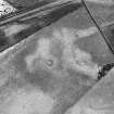
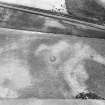
NH 734 487. Air photography has revealed what may be an unenclosed settlement 450m SW of Lonnie farmhouse. It comprises a ring-ditch about 13m in diameter which contains a ring of pits; an arc of a possible second ring-ditch;and a pit-circle.
RCAHMS 1979; Visible on RCAHMS air photographs IN 3092-4: flown 1977.
Tolan notes two pit-circles, each surrounded by a ring-ditch.
M Tolan 1988.
Recent aerial photography (RCAHMSAP 1996) has revealed additional cropmarks suggesting that this is an unenclosed settlement with at least three round houses each comprising of a ring-ditch enclosing a pit-circle, with an internal diameter of about 15m. The most westerly has a broad outer ditch, while the other two have narrow arcs of ditch surrounding the pit-circle. A number of pits are scattered around the immediate area of the round houses. These cropmarks were previously interpreted as enclosures and pit-circles, then as an unenclosed settlement and pit-circle. The remains of a chambered cairn and the cropmarks of two enclosures have been recorded in the surrounding area (NH74NW 14, NH74NW 48, NH74NW 87 ).
Information from RCAHMS (KJ) 28 March 2000.
Field Visit (February 1978)
Lonnie NH 734 487 NH 74NW 26
Air photography has revealed what may be an unenclosed settlement 450m SW of Lonnie farmhouse. It comprises a ring-ditch about 13m in diameter which contains a ring of pits; an arc of a possible second ring-ditch; and a pit-circle. See also nos. NH74SW 25 and NH64SE 37.
RCAHMS 1979, visited February 1978
Aerial Photographic Interpretation (26 February 2014)
Following a review of the aerial photographic evidence, the circles of pits recorded as cropmarking on aerial photographs are thought to represent the remains of later prehistoric roundhouses belonging to an unenclosed settlement. As such the pit circle classifications previously applied have been removed.
Information from RCAHMS (KMM) 26 February 2014
Geophysical Survey (September 2015 - December 2015)
NH 73745 49090 (NH74NW 26, NH74NW 147, NH74NW 48, NH74NW 142) A magnetometer survey was undertaken, September – December 2015, over 80.3ha of farmland near Castle Stuart in advance of a proposed golf course
development. The survey utilised a vehicle-towed MAGNETO MX V3 Sensys large area survey system that incorporated 16 fluxgate gradiometers separated at intervals of 0.24m on a 3.85m wide trailer. Several prehistoric enclosures and settlement remains were mapped. These included new discoveries and sites previously known from aerial reconnaissance. An extensive possible prehistoric field system was discovered near Castle Stuart Golf Links.
Archive: Highland Council and NRHE (intended)
Funder: Castle Stuart Golf Course
Oliver O’Grady – OJT Heritage and Atlas Geophysical Ltd
(Source: DES, Volume 17)

