
Fetlar, Outer Brough


Building(S) (Medieval) - (Post Medieval), Monastic Settlement (Early Medieval)
Site Name Fetlar, Outer Brough
Classification Building(S) (Medieval) - (Post Medieval), Monastic Settlement (Early Medieval)
Alternative Name(s) Strandiborough
Canmore ID 1421
Site Number HU69SE 1
NGR HU 67160 93153
Datum OSGB36 - NGR
Permalink http://canmore.org.uk/site/1421


- Council Shetland Islands
- Parish Fetlar
- Former Region Shetland Islands Area
- Former District Shetland
- Former County Shetland
Field Visit (9 September 1930)
Indeterminate Site, Inner Brough, Strandburgh Ness. There is no structural evidence of a broch on the spot known as the Inner Brough, near the neck of the promontory of Strandburgh Ness at the N.E. corner of the island. The islet called the Outer Brough could not be visited. As a result of enquiries, however, it was ascertained that, although there are no distinct traces of a broch-like building on the Outer Brough, it was possible, in recent years, to follow a line of wall along its S. edge. It was also stated that the ruined foundations of a dozen or more small houses or shelters used to be visible on the Inner Brough. The latter area is now so much overgrown with long grass that nothing of the kind can be detected.
RCAHMS 1946, visited 9 September 1930.
Field Visit (28 July 1970)
HU69SE 1 6715 9315
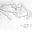
(HU 671931). On Outer Brough, an exposed rock stack separated from Strandburgh Ness by a deep geo some 15m wide, there are two groups of buildings, rectangular on plan with slightly bowed sides and rounded corners, recorded in the Ordnance Survey Name Book (ONB) as 'Pictish houses'.(ONB 1878) (RCAHMS 1946. Not visited)
The eastern group of 6 buildings average 5-6m in length and 3m in width internally, with double-faced walling almost obliterated by wind and wave erosion, despite being some 32m above sea level. The western group, situated on the highest part of the stack and somewhat better preserved, are of the same dimensions as the other group with the exception of one building. This appears to be of a more substantial nature, measuring about 19m in length and 4m in width, and sub-divided into two compartments with another abutting at a right angle on the N side. No entrances could be identified in either group. Along the S edge of the stack, immediately opposite the mainland, the remains of a drystone wall can be traced for a distance of about 40m. Access to the stack is obtained by means of a grassy incline at the E end of the geo.
The site has clearly been selected for the purpose of refuge and isolation, and may be compared with Kame of Isbister (cf. HU 39SE 4) and Birrier (cf. HU 49SW 1), both of which have been tentatively classified as early Celtic monastic settlements analogous to Brough of Deerness, Orkney (cf. HY50NE 14).
Surveyed at 1/10000; enlargement at 1/1250
Visited by OS(AC) 28 July 1970
Note (14 February 2001)
Six unroofed buildings are depicted on the 1st edition of the OS 6-inch map (Orkney and Shetland (Shetland) 1881, sheet xiii). Five unroofed buildings are shown on the current edition of the OS 1:10000 map (1973).
Information from RCAHMS (SAH) 14 February 2001
Note (4 March 2016 - 18 May 2016)
The Outer Brough of Strandburgh Ness, is an island separated from the mainland of Fetlar by a yawning chasm some 12m wide at its narrowest and 30m deep. Now it is accessible only from the sea, but in times past it must have been connected by a neck towards its WNW end, where the remains of a wall have been recorded along the edge of the cliff. Although not recorded as antiquities, OS surveyors preparing the 1st edition OS 6-inch map (Shetland 1878, sheet 13) evidently landed on the island and depicted a cluster of buildings on its summit and upper E slope, and these were subsequently resurveyed in more detail with a series of other buildings lower down on the E by the OS in 1970. The island measures some 200m in length from E to W by 55m in breadth, sloping down to E and W to either side of a central summit, but whereas the W end and N and S flanks are entirely cliff-girt, on the E the rock outcrops descend more gradually into the sea. Upwards of seventeen stone-founded buildings are shown on the OS plan, forming a series of conjoined clusters. As at Brei Holm, Papa Stour (Atlas No.4197) the Outer Brough was identified by Raymond Lamb as one of a number monastic sites with a cluster of rectangular buildings likely to be of Norse date (1973; 1976), though the rather earlier chronology established there and the possibility that it was once an enclosed promontory should also be borne in mind here, where there is also a wall along the cliff-edge facing the mainland. If a promontory enclosure, the grass-grown upper slopes of its interior currently extend to about 0.74ha, and including the outcrops descending to the sea on the increases it to 0.87ha. Here, however, there are similar buildings on the Inner Brough (Atlas No.4196), a much larger peninsular to which access at the neck is barred by a substantial bank.
Information from An Atlas of Hillforts of Great Britain and Ireland – 18 May 2016. Atlas of Hillforts SC4195

