
Fort George, Military Ranges


Military Training Site (20th Century)
Site Name Fort George, Military Ranges
Classification Military Training Site (20th Century)
Canmore ID 142086
Site Number NH75NE 27
NGR NH 7800 5700
NGR Description Centred NH 7800 5700
Datum OSGB36 - NGR
Permalink http://canmore.org.uk/site/142086


- Council Highland
- Parish Ardersier
- Former Region Highland
- Former District Inverness
- Former County Inverness-shire
NH75NE 27.00 centred 7800 5700
NH75NE 27.01 centred NH 7895 5655 Tracked Target Range
NH75NE 27.02 centred NH 7700 5700 Rifle Ranges
NH75NE 27.03 c. 77 57 Married quarters
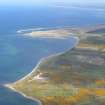
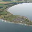
A large area of military ranges are depicted on the current chart copy edition of the OS 1:10000 map (1991) lying to the E of Fort George (NH75NE 3.00).
Information from RCAHMS (DE) March 1999.

