
St Columba's Chapel


Burial Ground (Medieval) - (Post Medieval), Chapel (Medieval) - (Post Medieval)(Possible)
Site Name St Columba's Chapel
Classification Burial Ground (Medieval) - (Post Medieval), Chapel (Medieval) - (Post Medieval)(Possible)
Alternative Name(s) Alterlie, Burial Place
Canmore ID 14207
Site Number NH74NW 2
NGR NH 7151 4949
Datum OSGB36 - NGR
Permalink http://canmore.org.uk/site/14207


- Council Highland
- Parish Petty
- Former Region Highland
- Former District Inverness
- Former County Inverness-shire
NH74NW 2 7151 4948.
(NH 7151 4948) St. Columba's Chapel (NR) (Site of)
OS 6" map, (1967)
There was a burial-place at Alterlie. 'The boundary walls can still be traced. The enclosed space measures 36 yards by 18 yards. The longest axis lies north and south. Towards the north end there are traces of a building within the enclosure, which in all probability was the chapel'.
T Wallace 1921.
There was a Columban house at Petty.
A Ross 1898.
The site lies within an area of dense gorse and refuse No trace of the chapel is to be seen. The remains of several old banks are evident, any one of which could have formed part of the boundary wall of the burial place; no enclosed space having the dimensions given by Wallace (1921) was found.
Visited by OS (E G C) 26 April 1962.
Field Visit (February 1978)
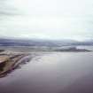
Alturlie Point, Chapel NH c. 715 494 NH74NW 2
Nothing can now be seen of a chapel and burial-ground which are said to be associated with St Columba. In 1914 Wallace noted the discovery of 'bones' at a depth of 0.9m within an enclosure measuring 33m by 16.5m; a building which stood within the N end of the enclosure may have been the chapel.
RCAHMS 1979, visited February 1978.
(OS 6-inch map, Inverness-shire, 2nd ed., 1907, sheet iv; Wallace 1918, 169).

