
Cantraybruich


Chambered Cairn (Neolithic)
Site Name Cantraybruich
Classification Chambered Cairn (Neolithic)
Canmore ID 14151
Site Number NH74NE 16
NGR NH 77834 45946
Datum OSGB36 - NGR
Permalink http://canmore.org.uk/site/14151


- Council Highland
- Parish Croy And Dalcross (Inverness)
- Former Region Highland
- Former District Inverness
- Former County Inverness-shire
NH74NE 16 7781 4594.
(NH 7781 4594) Stone Circle (NR) (Remains of)
OS 6"map, Inverness-shire, 2nd ed., (1906)
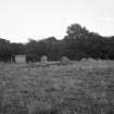
Cantraybruich (? Clava-type): The site lies on the flat valley floor immediately beside the river. When seen by Fraser (1884) it had already been so much destroyed .. that only six large stones remained in situ. These boulders probably represent the W arc of the kerb of a cairn with a diameter of about 63ft. They are not contiguous and presumably an intervening stone has been removed from between each of them. The two southermost have now fallen, and one of them is broken. The heights of the stones vary from 2ft 3ins to 5ft 6ins.
W Jolly 1882; J Fraser 1884; A S Henshall 1963.
All that remains of this cairn, is the kerb as described above. In the corner of the field at NH 7785 4549, there are numerous large stones lying prone, which were removed from the cairn by the previous farmer of Cantraybruich (Information from Mr Patterson, Cantraybruich Farm, near Culloden).
Revised at 1/2500.
Visited by OS (N K B) 12 August 1964.
Site recorded during a survey at Dalcross Estate under the Historic Scotland Ancient Monument Survey Grant Scheme.
NH 7781 4594 Cantraybruich Chambered cairn.
Sponsors: Historic Scotland, Mr Robin Buchanan.
T Rees 1998
Field Visit (20 August 1943)
Stone circle, Cantraybruich.
This assemblage of stones, noted on the OS 6-inch map as the remains of a stone circle but probably the last vestiges of the peristalith of a Clava cairn, stands on arable ground on the left bank of the River Nairn about 450 yds SE of the farm of Cantraybruich. Its position is just S of the inflow of a small tributary burn, and so close to the present river-bed that it is possible that some part may have been destroyed by erosion. It consists of six large stones, disposed as shown in the plan; but too much importance should not be attached to their present arrangement as the monument has been seriously disturbed and perhaps only Stones 1 and 2, or possibly Stone 3 as well, are in their original positions. A pile of stones and turf has been built on the W side of and partly covering Stone 3; Stone 5 has toppled eastwards, the plan showing what seems to have been its former position; and Stone 6 is prone. There is thus insufficient evidence to identify the monument with confidence as part of the peristalith of a cairn. The dimensions of the stones are as follows, in the order height, breadth, thickness:- Stone 1, 3ft 2in by 4ft 2in by 2ft; Stone 2, 4ft 8in by 2ft 8in by 2ft 9in; Stone 3, 3ft 3in by 5ft 1in by more than 1ft 3in; Stone 4, 2ft 6in by 5ft 6in by 1ft 8in; Stone 5 (perhaps originally), 4ft 1in by 4ft 6in by 1ft 6in; Stone 6 (exposed surface) 3ft 8in by 3ft 8in.
Visited by RCAHMS (AG) 20 August 1943
Map ref: v (‘Stone circle, remains of’)
Field Visit (June 1978)
Cantraybruich 1 (INV 15) NH 778 459 NH74NE 16
Four earthfast and two prostrate stones may be the remains of a Clava cairn.
RCAHMS 1979, visited June 1978
(Henshall 1963-72, i, 367)

