
Hoy, Walls, Lyness, Royal Naval Oil Terminal, Pier


Pier (20th Century)
Site Name Hoy, Walls, Lyness, Royal Naval Oil Terminal, Pier
Classification Pier (20th Century)
Alternative Name(s) Golden Pier; Scapa Flow; Lyness Pier
Canmore ID 140878
Site Number ND39SW 20.05
NGR ND 31355 94640
Datum OSGB36 - NGR
Permalink http://canmore.org.uk/site/140878


- Council Orkney Islands
- Parish Walls And Flotta
- Former Region Orkney Islands Area
- Former District Orkney
- Former County Orkney
ND39SW 20.05 centred 3135 9463
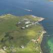
A World War II concrete pier now rebuilt for modern ro-ro ferries.
Visited by RCAHMS (DE, GS, SW), August 1997
Field Visit (August 1997)
Lyness served as the centre for naval operations throughout WWI & II. The sheltered harbour offered an ideal location for refuelling and maintaining the fleet. The extensive remains of a wide range of structures associated with the base include:
(i) A boiler, a building, oil tanks, a military camp and a pillbox (ND 39 SW 20.01 -20.05).
(ii) Lyness steam pumping station and oil tank: Scheduled (HS Index 5438, 07ND 309 947- 07ND 310 947). The steam pumps were used to drive fuel oil into storage tanks. Originally coal-powered, they were converted to oil-firing in 1936. They now form a display within the Lyness Interpretation Centre. The oil tank, built in 1917, has a capacity of 12,000 tons and is the last survivor of four such tanks originally housed here.
(iii) A hand crane and pier (ND39SW 17)
Moore and Wilson, 1997
Coastal Zone Assessment Survey
Geophysical Survey (April 2010 - May 2010)
ND 3135 9468 A geophysical survey was carried out across
the areas of Golden Wharf and Lyness Wharf in April–May
2010 prior to development. The work consisted of a c4ha
gradiometer survey, which aimed to identify services and
potentially unexploded ordnance and a GPR survey of a
further 1.3ha, which aimed to locate further services and
any voids.
The gradiometer survey identified a number of anomalies
thought to relate to services. Other more discrete anomalies
may be indicative of the presence of large ferrous objects,
ground disturbance or structures. A number of anomalies
were in proximity to buildings and may represent ‘ferrous
spread’ from these structures. Further ferrous noise visible
across the site reflected the material used to make up the
ground in this area, together with the subsequent uses
of the wharf and surrounding area. Some of the strong
ferrous anomalies identified could relate to the position of
ordnance. However, it is impossible to differentiate between
the response given by these and that given by other large
ferrous objects. The GPR survey showed a number of
interesting anomalies, but the data were dominated by high
amplitude responses reflecting the various materials used
and construction methods employed over different parts of
the site.
Archive: ORCA Geophysics
Funder: Orkney Islands Council

