
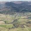
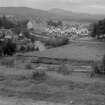
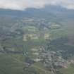
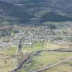
Kingussie, General


Burgh (Medieval), Town (Period Unassigned)
Site Name Kingussie, General
Classification Burgh (Medieval), Town (Period Unassigned)
Canmore ID 14075
Site Number NH70SE 13
NGR NH 75842 00703
Datum OSGB36 - NGR
Permalink http://canmore.org.uk/site/14075


- Council Highland
- Parish Kingussie And Insh
- Former Region Highland
- Former District Badenoch And Strathspey
- Former County Inverness-shire
Architect of Kingussie public hall, shops and houses: Alexander Ross
(I.C. March 30, 1876).
Feu-plan of new village, 1799
(Edinburgh Evening Courant, Jan 24, 1799)
Desk Based Assessment (September 2013)
Kingussie takes its English name from the Gaelic Ceann á Ghuibhsaich meaning ‘at the head of the pines’, harking back to when the settlement was surrounded by an extensive pine forest, now much depleted.
The earliest origins of settlement in the Kingussie area are said to date back to the latter half of the 6th century AD, when St Columba, or one of his followers, is believed to have established a church beside Gynack Burn, near what is now Old Mill Road.
However, this did not bring settlement to this side of the River Spey, as most of the early settlement took place on the eastern side at Ruthven in the 13th century, when Ruthven Castle was built (c.1229) by the Comyn Earls of Badenoch, who also owned the Kingussie estate. Alexander Stewart, 1st Earl of Buchan and Lord of Badenoch (1343 – 94 or 1405), the infamous ‘Wolf of Badenoch’, had one of his bases at Ruthven, and legend has it that in July 1394 he played chess with the Devil at Ruthven, and was killed by lightning during a terrible storm.1 In c.1440, James II granted the Lordship of Badenoch to Alexander Seton, later Alexander Gordon, 1st Earl of Huntly, and in 1464 Kingussie was created a burgh of barony by James III, with Alexander Gordon, 1st Earl of Huntly as landowner.2
Some settlement took place during the 16th century on land within the boundary of the present town, including the old church which was built on Main Street. The remains of the former graveyard are still visible behind the buildings on Main Street.
Ruthven Castle experienced a period of turbulence during the 17th and 18th centuries: attacked and captured by General Leslie (1647); garrisoned by Oliver Cromwell’s troops (1649); burnt down by John Graham of Claverhouse, 1st Viscount of Dundee (‘Bonnie Dundee’) (1689); rebuilt as military barracks by General Wade (1719); extended (1734); attacked and burnt (1746).3
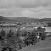
Construction of better roads in the area, along with the bridging of the Spey during the mid-18th century, saw Kingussie grow as a more popular site for settlement, and Ruthven’s dominance as the main settlement in Badenoch declined.
The entry for the ‘United Parishes of Kingussie and Inch’ in the Old Statistical Account of Scotland was written by the minister, Rev. John Anderson in 1792. In this he states that ‘there is no village either in the parish, or in the whole district’ (OSA, 1792, 38). However, by the time the New Statistical Account is written by Rev. George Shepherd in 1835, ‘there are now two [villages] in this parish alone; of a combined population of upwards of 700.’ (NSA, 1835, 79).
The first ideas about having a planned town in Badenoch came in the 1770s, shortly after the Duke of Gordon instructed the bridging of the River Spey at Ralia in 1765.4 However, the first site considered was actually at ‘moor of Clune’, which is now where modern-day Newtonmore stands.5
Planned towns were popular with landowners in Scotland during the 18th and 19th centuries as a means to implementing and managing change throughout their estates. Many were based around a new industry to employ the town’s residents and to generate higher incomes for the landowners. Others became key market places for the produce generated on surrounding agricultural lands as improvements in farming methods were implemented.
Kingussie was one such town, which developed as a market place. Prior to the planned town coming into existence, as early as the late 1750s there were moves to establish a textile industry at Kingussie. It was not until the 1780s, however, that a mill complex was built alongside the River Gynack. One of the Gordon estate’s tenants, John MacHardy, took on the role of managing the mill, and various subsidies were sought to expand the complex with additional buildings to store flax and so on. However, the scheme was not particularly successful, and the mill had ceased operations by the time the new town was being surveyed and laid out.6
The first indication of consideration being given to establishing a new town in Badenoch came in 1770, when James Ross, factor for part of the 4th Duke of Gordon’s estates, gave a set of ten instructions to a young land surveyor, Alexander Taylor, who had just joined the Duke’s service. Much of the instructions were concerned with the farmland, woods and boundaries on the estate, but the final instruction states:
‘You may attend in the course of your survey...to be able to point out on the plan, the most convenient places in the estate [Badenoch] for Bleachfields both in the point of situation, soil and water and if any part of the estate appears very convenient for the situation of a new village you may mark it on your plan.’ (quote taken from article ‘VI –The Idea of a New Town’, Strathspey & Badenoch Herald, 1971)
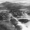
In 1770, following on from the issuing of these instructions, surveys were carried out and the report of contents to accompany the resulting plans was produced in August 1773. However, it was not until the 1790s that any action was taken towards formally establishing a new town. In 1796, the 4th Duke’s ex-wife, Duchess Jane, took up residence at Kinrara, where she employed Rev. John Anderson, minister of Kingussie since 1782, as her factor, and together they persuaded the 4th Duke to embark upon this project. Employing the eminent land surveyor and town planner George Brown (who also planned the new towns of Buckie, Lossiemouth and Bishopmill), and the Duke’s factor for Badenoch, William Tod, the first proper surveys and feuing plans for Kingussie were laid out ‘exhibiting intended figure and division of separate tenements, streets and lanes’ in 1798 (quote taken from article ‘VII – The Site of the New Town’, Strathspey & Badenoch Herald, 1971).
Following on from this, January and February 1799 saw adverts being placed in four issues of The Aberdeen Journal, and also later in the Edinburgh press. Several applications for feus had been received in the spring and summer that year, and George Hosack, a resident from Ruthven, marked out the Square in the autumn. The first building work on designated plots was carried out in August 1799.
From this first laying out, the town quickly took shape, with several key buildings being built in the 19th century, and the town became a thriving hub for the Badenoch area. Francis H Groome visited the town between 1882 and 1885 as part of his ‘Ordnance Gazetteer of Scotland: A Survey of Scottish Topography, Statistical, Biographical and Historical’ publication, and stated that the town has:
‘... post office with money order, savings bank and telegraph departments; branches of British Linen Company and Commercial Banks; National Security Savings Bank; 4 insurance agencies; good hotel; recent drainage and water works; daily coach communication with Fort William; court house (1806); parish church (1792, 650 sittings); Free Church; farming society; reading club; and fairs on 3rd Wednesday of August and Tuesday of May, September and November. Population (1841) 460; (1861) 646; (1871) 676; (1881) 645. Houses (1881) 102 inhabited, 12 vacant, 2 building.’7
The arrival of the railway to Kingussie in 1863 was a key event in the town’s history, as it became the rest stop for trains between Perth and Inverness. A refreshments room was provided in the station, and the original gents’ toilets had 40 urinals. Lunch and high tea would be ordered by passengers then packed into baskets to load on the train at the station.8
In 1867, Kingussie was created a Police Burgh, which was a means of governing and carrying out improvements in the town. A group of Commissioners was elected annually to oversee improvements, including paving streets, lighting, cleansing, water and gas supplies, preventing infectious diseases and appointing police officers, surveyors and watchmen. One of the first elected Commissioners in Kingussie was Dr J C Orchard, who lived at Church Hill on Duke Street around this time and is discussed later in this report.
As part of the ongoing improvements of the later 19th century, Kingussie Public School was built in Ruthven Road in 1875, replacing the previous building on the High Street; it was extended in 1907, and further still with the installation of huts in the 1960s. Kingussie had an excellent educational reputation and pupils came to the town’s school from the Islands, e.g. Skye, until the reorganisation of education services in the Highlands in the 20th century. These pupils boarded in various boarding houses in the town, providing a vital source of income for local landladies.
With the railway came ‘health tourism’, with visitors looking to benefit from the fresh clean Highland air. Robert Louis Stevenson was one eminent visitor who took the air in the town during the 1880s; some of his poems are thought to relate to his time in the town. In particular, ‘The Disputatious Pines’ is believed to be based on three pine trees still existing on the southern edge of the knoll on which the church sits and overlooking the site of Am Fasgadh. Another, ‘Where Go The Boats?’, is thought to describe his enjoyment of sending paper boats sailing down the River Gynack. 9, 10
The great outdoors and sport in general was growing in popularity during the last decades of the 19th century. In 1891 a nine-hole golf course was established by Captain MacHardy, Chief Constable of Inverness-shire, to the north of the town on the west bank of the River Gynack. The course was expanded to 18 holes and a new clubhouse built c.1908.11
In 1893, the Highland sport of shinty’s Camanachd Association was formed when the 33 recognised clubs playing at that time met in the Victoria Hall, Kingussie. Shinty had been played in Kingussie since 1867, well before the sport became ‘organised’ in 1890. The Kingussie Shinty Club was formed following the split of the Badenoch Shinty Club (established 1889) into Kingussie and Newtonmore. The first President of the club was Peter MacKenzie, also known as the Count de Serra Largo, who erected the MacKenzie Fountain at the entrance to the railway station in 1911.12
Further attempts at establishing industry in the town were made in 1896 with the opening of the Speyside Distillery. However, the business only operated for ten years, due to a number of factors including bad management, poor water quality, and the type of barley being used not being suited to whisky distilling. The buildings were eventually demolished in 1925, with much of the stone used as foundations and bridges for the A9 trunk road.13
The turn of the 19th/20th century saw a rise in sanatoria being built to assist with the treatment of pulmonary tuberculosis (TB). A number were built across Scotland in the early 20th century: Nordach-on-Dee (Glen o’Dee), Banchory (founded by Dr David Lawson based on the German sanatorium at Nordach, 1900-01); Sidlaw Hospital, Auchterhouse (founded by Lord Airlie and Provost Alexander Hay Moncur, 1901); Seaforth Sanatorium, Maryburgh, Dingwall (founded by Colonel Stewart-Mackenzie of Seaforth, 1906-8); Inverness County Sanatorium, Bridge of Oich (founded by Honorable Margaret Fraser of Lovat, 1908). Patients in these sanatoria followed a strict programme of rest and recuperation accompanied by healthy diet. In 1901, Dr Walter Frederick de Watteville, a Swiss doctor specialising in TB, established the Grampian Sanatorium on the west side of the River Gynack, above the town. Dr de Watteville believed that this site was the ideal place for the popular ‘open air treatment’, where patients were expected to spend as much time outside as possible, even sleeping outside. On 17th April 1899, Dr de Watteville married the local minister’s daughter, Mary Flora Mackenzie.14, 15 The Seychelles-born Dr Joseph Henri Napoléon Félix Savy (1885-1965) took over the sanatorium in the early 1920s, continuing the tradition of doctors from overseas taking on the pioneering work of treating TB in Scotland and the UK.16 The building was bought by the Sisters of the Charity of the Order of St Vincent de Paul in 1934, who continued to treat TB patients until the use of antibiotics to treat the disease was developed in the 1950s.
As was the case in most small towns across Scotland, the early 20th century saw a large number of grand villas springing up in the terraces above the town centre. The coming of the railway in 1863 had led to a rise in tourism to Kingussie, and the Highlands in general, and the growing popularity of the town for visitors meant many of these villas were let in the summer while the owners moved into small cottages in the grounds. This period also saw a number of hotels and other facilities come to the town including: the Post Office on Spey Street (moving from its previous home on the High Street in the building now known as Caberfeidh House), the United Free Church and the Parish Church Halls (all in 1909); Columba House (former manse) (1922-3); introduction of a trunk telephone system (1924); electricity provided by the Grampian Electricity Company (1926); Catholic Church and house (1932).
The town continued to grow during the 20th century, becoming one of only a handful of urban centres for the largely rural Badenoch area. In an effort to attract new residents into the urban centres, and provide housing for those moving off the land, a development of Swedish-style timber-clad semi-detached houses was built in the 1940s to the north of the High Street in Cluny Terrace.17 This style of housing was popular across Scotland at this time, many of the developments being built by the Scottish Special Housing Association, for example at Eden Drive, Rothesay; Carstairs on the outskirts of Lanark; Linlathen area, Dundee.
The Kingussie seen today still retains much of the original grid-iron street layout at its centre. It has continued to expand during the latter 20th century, with a number of housing estates growing up on its outskirts from the 1970s, and the associated secondary school serving a wide catchment area. The new police station was built on the High Street in 1973,18 and refurbished in 2005.19 The upgrading of the A9 trunk road in the 1970s has had mixed effects: the town no longer has to cope with the high volume of traffic which uses the road, but is now literally bypassed by a huge number of potential visitors.
In 2003, the Cairngorms National Park was established, and Kingussie falls within the boundaries of the Park. With this designation comes further potential to attract visitors back to the town.
Notes
1. www.stravaiging.com/history/castle/ruthven-castle-kingussie-and-insh
2. Strathspey & Badenoch Herald, 1971, ‘The Founding of Kingussie’ by George Dixon
3. www.stravaiging.com/history/castle/ruthven-castle-kingussie-and-insh and http://www.electricscotland.com/webclans/earldoms/chapter3s2.htm
4. www.kingussie.co.uk/timeline
5. Information from Ross Noble, Newtonmore, 4th March 2013
6. Strathspey & Badenoch Herald, 21st January 1999, ‘The Founding of Kingussie’ by George Dixon
7. http://www.scottish-places.info/scotgaz/towns/townhistory1969.html
8. Information from Joe Taylor, Kingussie, 20th March 2013
9. www.luminarium.org/nineteenth/stevenson/pines.htm
10. www.scottishpoetrylibrary.org.uk/poetry/poems/where-go-boats
11. www.kingussie-golf.co.uk/page.aspx?pid=14960
12. www.kingussieshinty.com/?page_id=9
13. www.kingussie.co.uk/timeline
14. Information from Joe Taylor, Kingussie, 20th March 2013
15. http://www.diack.co.uk/diackped/77470.htm
16. www.seychellesweekly.com/July%2018,%202010/top5_a_famous_seychellois.html
17. Robertson, Uiga & John, 1999, ‘Kingussie: caught in the light’, Perth: Farquhar & Son Ltd, p.16
18. Robertson, Uiga & John, 2002, ‘Kingussie: at the head of the pines’, Perth: Farquhar & Son Ltd, p.62
19. Robertson, Uiga & John, 2006, ‘Kingussie: lasting impressions’, Perth: Farquhar & Son Ltd, p.90
Extract taken from: ‘The History of Am Fasgadh’ by Kevin Grant and Lynn Kilpatrick (RCAHMS), September 2013, produced in association with Am Fasgadh Regeneration Company (Kingussie) Ltd.

