
Tulloch


Clearance Cairn(S) (Period Unassigned), Field System (Period Unassigned), Hut Circle(S) (Prehistoric)
Site Name Tulloch
Classification Clearance Cairn(S) (Period Unassigned), Field System (Period Unassigned), Hut Circle(S) (Prehistoric)
Alternative Name(s) Bonar Bridge, Plots 1-3, Leithhall
Canmore ID 14040
Site Number NH69SW 5
NGR NH 618 925
NGR Description Centred NH 618 925
Datum OSGB36 - NGR
Permalink http://canmore.org.uk/site/14040


- Council Highland
- Parish Creich (Sutherland)
- Former Region Highland
- Former District Sutherland
- Former County Sutherland
NH69SW 5 centred 618 925
('A': NH 6154 9301) Hut Circle (NR)
('B': NH 6162 9265 and 'C': NH 6162 9267) Hut Circles (NR)
('D': NH 6170 9238) Hut Circle (NR)
('E': NH 6188 9257) Hut Circle (NR)
('F': NH 6192 9260) Hut Circle (NR)
(Name: NH 6179 9262) Field System (NR)
OS 25" map, (1969)
('G': NH 6207 9265) Hut Circle (NR) (Name: NH 6203 9270) Field System (NR)
OS 25" map, (1967)
Hut circles and enclosures.
RCAHMS 1911.
Centred at NH 618 925, on the hill of Druim Liath, is a settlement of seven stone-walled huts ('A' - 'G') and an associated field system.
The hut diameters are given between wall centres.
Hut 'A' is oval and set into a NE-facing slope. It measures c.9.0m NW-SE by c.7.5m, with the wall spread to c.2.0m all round. The SE arc is destroyed. The entrance is not evident.
'B' measures c.14.5m NW-SE by c.13.5m. It is circular internally within a wall of bare rubble stones spread to c.2.5m at the rear splaying to c. 4.0m at the 'clubbed' entrance in the SE which is flanked on its SW side by an upright block. In the interior, against the NW wall, is a quantity of loose stones described by the RCAHMS as a hut, but it appears to be tumble or mutilation.
'C', 20m to the NNW, is the same size as 'B', with a 'clubbed' entrance in the SE, but is turf-covered.
'D' is at the base of a SW-facing slope and measures c.9.5m NW-SE by
c.8.5m, with a mutilated wall spread to c.2.5m all round. The entrance, in the SE, is ill-defined.
'E' is destroyed in the NE by a quarry. It measures c.11.5m NW-SE,
with the wall spread to c.3.0m. The entrance was probably in the ESE where there is a gap. The 'enclosure' described by RCAHMS 30 yards to the S is a robbed stone clearance heap.
'F' is set into an E-W slope and measures c.13.0m E-W by c.12.0m. It is circular internally within a wall spread to c.2.5m at the rear splaying to c.4.0m at the poorly-defined 'clubbed' entrance in the E. Although the RCAHMS topographical description fits 'F' (with ' D' in association) their description of the hut fits 'G'. They have either not seen both huts, or have combined their reports by mistake.
'G' measures c.13.6m NW-SE by c.12.0m. It is circular internally within a wall of bare rubble stones, c.2.6m thick at the rear splaying to c.4.0m at the poorly-defined 'clubbed' entrance in the SE. It occurs eccentrically within the indistinct remains of a stone wall, spread to
c.2.5m, which is almost obliterated in the S. The entrance through this wall leads directly into that of the hut suggesting that the two are contemporary. (See NH69SW 41).
All the other structures described by the RCAHMS appear to be mutilated stone clearance heaps.
The field system is comprised mainly of stone clearance heaps and is best defined in the area between huts 'B' and 'E', where occasional lynchets form plots averaging about 50.0m by 30.0m.
Visited by OS (R L), 8 October 1969.
No change.
Revised at 1:2500 and 1:10,000.
Visited by OS (J B), 5 September 1980.
NH 61 92 (centre) A desk-based assessment and walkover survey were made in December 2001 of four pipeline routes in the Bonar Bridge and Ardgay areas. The following additional sites were located:
NH 6208 9266 Circular enclosure.
Full report deposited in Highland SMR and the NMRS
Sponsor: Earth Tech Engineering Ltd for NOSWA
S Farrell 2002.
NH 619 927 (area) Watching briefs were undertaken between October 2004 and September 2005 for a house plot and associated services in an area of a number of archaeological features (NH69SW 5). No archaeological deposits or features were revealed.
Full report lodged with Highland SMR and NMRS.
Sponsors: Mr & Mrs J Murray.
S Farrell 2005.
Field Visit (2 October 1909)
69. The Tulloch, Bonarbridge.
The Tulloch, and Druim Liath, which is a portion of it, are covered with stony mounds and hut circles. Of the former by far the greater number present features suggesting that they are the ruins of huts. Most of them are circular, with a diameter of 16', some are oblong, and some of the heaps are so long as to suggest that several huts have stood attached in a row. Among them here and there are conical mounds overgrown with vegetation, but these are much less numerous.
[NH69SW 14] About ¼ mile E. of the school-house and a short distance to the E. of ‘Carn an fhitich’ (No. 85) are a number of the supposed hut ruins. One heap of stones lying E. and W. measures 30' x 17'. Adjacent to it, in the form of a crescent, is a long mound facing S., some 60' long by 20' wide at the centre. Near the top of the hill, towards the SW., are a few small overgrown mounds measuring from 12' to 16' in diameter. On the same part of the hill is an oval heap of stones measuring 20' x 14'. The remains of old walls are visible among the ruins. In one instance a portion of wall is succeeded by two mounds about 15' apart, and 15' to 16' in diameter.
[NH69SW 14] Some ½ m. NW. of the W. end of Loch Migdale are the ruins of a hut circle measuring interiorly 24' X 20', with foundations of walls running from it. To the N. of it, some 40', is a heap of stones lying N. and S., measuring 40' x 18', and showing marked depressions near the centre. Near by are a number of conical mounds overgrown with vegetation, some 12' in diameter, and about 1½' in height.
[NH69SW 14] About ¼ m. NNW. of the church is a well-marked hut ruin. It measures 16' in diameter over all, and the interior depression, which is clearly defined, about 7' in diameter. The entrance appears to have been from the SE. Some 80 yards NNW. of it are two small mounds some 18' in diameter, and 2' to 3' in height.
On the W. side of the road which crosses Druim Liath from N. to S., and towards the N. side of the hill, is a small circular enclosure measuring 12' in interior diameter. The entrance appears to have been from the W. Some 30 yards to the N. of it is a semicircular enclosure facing NW., measuring some 30' in diapieter, with a bank about 9' thick. Opposite the end of the bank at the SE. is a low heap of stones about 14' in diameter.
On the N. side of Druim Liath, some ¾ m. NNE. of the Poorhouse, is a circular enclosure with an interior diameter of about 30'. The wall, which has been entirely broken down, has measured about 8' in thickness, and has been formed of boulders. On the K side a bank projects 25' in length and 15' in breadth, probably flanking the entrance. What appear to be the ruins of one or two small circular huts lie near to the S. On the SE. flank of the hill are the remains, almost obliterated, of several hut circles of simple oval form.
Some 300 yards SW. of the last described circle is another of simple form, measuring interiorly 26' x 32'. The entrance appears to been from the E., but the circle is overgrown with whins, and
the details are indefinite.
[NH69SW 20] On the top of the hill, near its NW. end, are some large heaps of stone, probably ruins of contiguous huts. Two of these heaps measure 28' in length by 16' in width.
On the top of Druim Liath, about 1 m. NE. of Bonarbridge, is a small hut circle measuring interiorly 20' x 23', with its entrance from the SE. 2' wide through banks 5' thick.
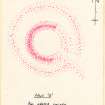
Some 100 yards W. is a circular enclosure with an interior diameter of 3', surrounded by the ruins of a wall composed of rather small stones, in its present state from 7' to 8' broad. The entrance has probably been from the ESE., and been 3' wide. Against the wall . in the interior, and slightly to the N. of a point opposite the entrance, are the ruins of a hut, similar in appearance to those all over the hill, measuring some 12' x 14' (fig. 9).
Some 15' to the N. are the remains of another circular enclosure with an interior diameter of 38'. The bank has been of stone and turf, the entrance from the ESE. about 9' wide.
[NH69SW 30] At the extreme NW. end of Druim Liath is a group of small mounds, about six in number, conical in form, of some 17' in diameter, and from 2' 6" to 3' in height.
Some 100 yards N., on the N. slope of the hill, is a hut circle with an interior diameter of 21' x 26'; the entrance is from the E., and the surrounding bank of turf and stone is about 4' thick. Several small mounds lie adjacent; none, however, having the hut features.
[NH69SW 3] At the W. end of the hill, some 120 yards N. of "Carn Liath," is a hut circle which has had an enclosing wall of stone 6' to 7' thick. The interior diameter is 28'. The entrance is from the E., and is 3' wide. Around it are small mounds of from 15' to 18' in diameter, mostly covered with vegetation.
OS 6-inch map: Sutherland Sheet cviii.
RCAHMS 1911, visited (AOC) 2nd October 1909.

