
Tombreck


Farmstead (Period Unassigned), Grain Mill (Period Unassigned), Lime Kiln (Period Unassigned)
Site Name Tombreck
Classification Farmstead (Period Unassigned), Grain Mill (Period Unassigned), Lime Kiln (Period Unassigned)
Alternative Name(s) Wester Tombreck
Canmore ID 140346
Site Number NN63NE 55
NGR NN 6514 3764
Datum OSGB36 - NGR
Permalink http://canmore.org.uk/site/140346


- Council Perth And Kinross
- Parish Kenmore (Perth And Kinross)
- Former Region Tayside
- Former District Perth And Kinross
- Former County Perthshire
NN63NE 55 6514 3764
A farmstead, comprising six roofed buildings, one of which is annotated as a 'corn mill' and one unroofed structure is depicted on the 1st edition of the OS 6-inch map (Perthshire 1867, sheet lxix). Two roofed buildings and four enclosures are shown on the current edition of the OS 1:10000 map (1981).
Information from RCAHMS (AKK) 23 February 1998.
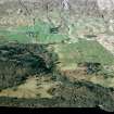
Tombreck farmsteading comprises a late 19th-century farmhouse and a group of 19th-century outbuildings, including a former mill. A limekiln stands to the NW, close to the E bank of the Allt an Tuim Bhric.
John Farquharson's 1769 Survey of the North Side of Loch Tay (National Archives of Scotland, RHP 973/1, Plan 9) depicts a substantial township here, named 'Wester Tombrecht' and comprising sixteen buildings and three enclosures, but none of these structures can be identified on the ground. The 1st edition of the OS 6-inch map (Perthshire 1867, sheet lxix) depicts a very different, more regular, layout of seven roofed buildings, one of them identified as a 'Corn Mill', and a lade. Apart from the mill, two of these buildings, a cottage and an outhouse, are still roofed, though derelict, while a third building, 50m to the SW of the steading at NN 65075 37580 has been reduced to its footings (BL00 1891). The mill, standing at the W corner of the steading, is a two-storey construction of mortared rubble with undressed quoins, measuring overall 13.8m from NW to SE by 8.6m transversely. The slate roof has partly collapsed. At the N end of the SW side of the building there is a wheelpit, fed by a lade approaching it from the NW. Two sockets in the wall above the pit, one with a projecting timber still in situ, appear to have carried an overshot flume. The tailrace runs off towards the SW. The mill machinery does not survive, though a threshing machine stands inside.
Further development of the steading before the end of the 19th century can be seen on the 2nd edition of the OS map (Perthshire 1900, sheet lxix NW), including the construction of the present farmhouse and the addition of a substantial range constructed against the NE side of the mill. Much of this range appears to have served as a large byre, with two drains running the length of the building.
Finally, the limekiln stands about 50m NW of the mill at NN 65077 37660 (BL00 1888). It has been set into rising ground on the NW and measures 4.7m from NW to SE by 2.3m within a wall whose facing stones are fire-reddened and cracked, especially at the NW end. The kiln opens towards the SE.
(BL00 1888-9, 1891, 2539)
Visited by RCAHMS (SDB) 30 November 2000

