
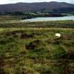
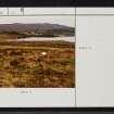
Loch Migdale


Henge (Neolithic) - (Bronze Age)
Site Name Loch Migdale
Classification Henge (Neolithic) - (Bronze Age)
Alternative Name(s) Lochend
Canmore ID 14025
Site Number NH69SW 36
NGR NH 6242 9160
Datum OSGB36 - NGR
Permalink http://canmore.org.uk/site/14025


- Council Highland
- Parish Creich (Sutherland)
- Former Region Highland
- Former District Sutherland
- Former County Sutherland
NH69SW 36 6242 9160.
(NH 6242 9160) Hut Circle (NR)
OS 25" map, (1967)
Hut Circle.
RCAHMS 1911, visited 1909.
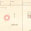
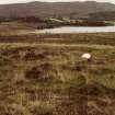
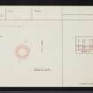
A well-preserved 'henge/barrow/cairn' situated on a low, dry rise close to the shore at the head of Loch Migdale. It measures 12.0m overall and comprises a level, circular platform 7.4m in diameter, surrounded by a ditch 1.1m wide and 0.2m deep, outside which there is a bank 1.2m wide and 0.2m high, revetted externally by a discontinuous line of small horizontal blocks. The bank is broken on the SE, where there is a gap leading to a causeway across the ditch. Both gap and causeway, about 0.6m wide, are slightly mutilated. There are a few clearance heaps in the vicinity.
Visited by OS (W D J) 11 June 1963 and (N K B) 14 November 1969.
Excavation of a segment of the work was undertaken by Dr Woodham in 1971. A layer of dark 'burnt' earth forming a rim 'about 3ft wide' around the central area, and a scatter of quartz chips were revealed, but no other finds were made. The interior appeared undisturbed and there was no evidence of barrow or cairn material. Dr Woodham (Clava, Inverurie) considers that this work is of the same category as the hengiform earthworks of Easter Ross (NH45NW 1, NH55NW 1, and NH55NE 5). The excavation has been backfilled.
Visited by OS (N K B) 6 October 1980.
Classified by OS as Henge: class 1.
(Undated) information from OS.
(NH 624 916) An evaluation was undertaken in April 2003 as part of a Time Team programme for Channel 4.
The henge monument is at most 12m in diameter as an earthwork. Woodham's 1970 excavation of the southern quadrant of the henge was re-excavated. The trench was at most 8.5m E-W by 6.5m. The 1970s section through the bank was also re-excavated and recorded. No other parts of the bank were removed, in order to restrict the damage to the upstanding earthwork.
In the centre of the henge, two stones found by Woodham were relocated and found to form packing stones for a large post-hole just off-centre of the henge. An area of fire-reddened bedrock extended away from the S edge of this post-hole. A number of stake-holes were identified within the henge, and a number of alignments could be postulated. There was a clear ring of post-holes concentric with the inner lip of the henge ditch.
The rounded termini of the henge ditch were identified and excavated. A large post-hole was recorded in the W of the causeway between the ditch termini and was thought to post-date the construction of the henge.
The outer bank of the henge was recorded in Woodham's re-excavated section. The bank was well-defined, approximately 1.4m wide and 0.25m high. No trace of a buried ground surface survived. The entrance between the banks was formed by a gap approximately 0.6m wide. A single standing stone protruded through the tail of the E bank terminus. The outer edge of the bank was revetted by a facade of large stone blocks. It was unclear if this was constructed as a drystone facade, now collapsed, or if it was designed as a rubble construction. The entrance gap in the bank was filled by a large oval stone hole, which had originally held a standing stone which is now snapped and recumbent in front of the stone hole.
A number of pieces of unworked stone were recovered, but no other finds were recorded. Environmental samples from the henge only produced a little wood charcoal and no identifiable plant remains.
The re-examination of the putative henge broadly supports Woodham's original interpretation of the monument as a henge. It has an external bank and internal ditch and single E-facing entrance. The single entrance would allow it to be classified as a Class 1 henge but the small size is consistent with its classification as a mini-henge.
The cairn lay to the SW of the henge and was examined by a trench covering its SW quadrant, at most 5m N-S by 4.2m. A spread of rubble was recorded, representing the collapsed cairn. The line of a possible kerb suggested that the cairn may originally have been 3.4m in diameter. A hollow and shallow pit were recorded in the centre of the cairn. The pit contained what was originally thought to be a wooden stake, but was subsequently shown to be compact peat that had filled a void left when the wooden stake was removed. No finds were recovered.
The interpretation of the cairn is less certain than that of the henge. The presence of a kerb and a central feature that may have held a timber post recalls monuments such as ring cairns and kerb cairns, some of which are also very small and which are often funerary monuments. The recurrent association of henges and other ritual or funerary monuments is well known. However, it should be noted that the proximity of the undated cairn to the henge at Migdale might be misleading, as what may be a post-medieval shieling lies nearby.
It seems likely, on morphological grounds, that the henge is of later Neolithic or earlier Bronze Age date.
Archive to be deposited in the NMRS.
Sponsor: Time Team.
R Smith 2003.
Field Visit (2 August 1909)
67. Migdale.
[NH69SW 36] Near the W. end of Loch Migdale is a hut circle. It is circular, with an interior diameter of about 28', and the entrance from the SE. about 3' across. The bank is some 6' wide, increasing to 8' 6” on either side of the entrance. An excavated small mound lies in rear of it.
To the S. of Culnara croft, between it and Loch Migdale, is a hut circle, much worn down. It appears to have been of the ordinary type.
To the W. of the miller's house, on the N. bank of Loch Migdale, are a number of small mounds.
OS 6-inch map: Sutherland Sheet cxi.
RCAHMS 1911, visited (AOC) 2nd August 1909.

