
Easter Fearn, Bridge


Road Bridge (19th Century)
Site Name Easter Fearn, Bridge
Classification Road Bridge (19th Century)
Alternative Name(s) Easter Fearn Burn; Easterfearn Bridge; Easterfearn Burn; Easter Fearn, Telford Bridge
Canmore ID 13877
Site Number NH68NW 23
NGR NH 64052 86289
Datum OSGB36 - NGR
Permalink http://canmore.org.uk/site/13877


- Council Highland
- Parish Edderton
- Former Region Highland
- Former District Ross And Cromarty
- Former County Ross And Cromarty
NH68NW 23 64052 86289
Location formerly entered as NH 64059 86288.
ARCHITECT: Thomas Telford (1803-21).
(Undated) information in NMRS.
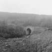
(Location cited as NH 641 862). Bridge over Easter Fearn Burn, built c. 1810-15 by engineer Thomas Telford. A tall semicircular arched rubble bridge.
J R Hume 1977.
Easterfearn Bridge. A single semicircular arch with buttressed abutments, of coursed rubble construction and span 40 ft (12.2m). The drystone approach-wall of rounded stones continues into the road embankment on the E.
G Nelson 1990.
This bridge carries the A836 public road over the Easter Fearn Burn about 650m SW of Easter Fearn steading (NH68NW 44). It is depicted, but not noted, on the current edition of the OS (GIS) AIB.
Information from RCAHMS (RJCM), 10 May 2006.
Construction (1817)
Completed 1817. Thomas Telford, engineer.
R PAxton and J Shipway, 2007.
Publication Account (2007)
Easter Fearn Bridge
(Institute Civil Engineers Historic Engineering Works no. HEW 0322)
A single 40 ft span segmental arch bridge passing 50 ft over the Easter Fearn Burn also on the Struie Road, completed by 1817. The rise of the arch is about 15 1/2 ft and its arch-ring consists of thin random sized stones and the spandrels are of coursed rubble stones.
The bridge adjoins a right-angle bend in the road and is remarkable for its tall approach walls of coursed large round rubble stones on a splayed base to provide stability. The engineer was Telford, the inspector, John Mitchell and the contractors D. Mackenzie & Ross.
R Paxton and J Shipway, 2007.
Reproduced from 'Civil Engineering heritage: Scotland - Highlands and Islands' with kind permission from Thomas Telford Publishers.

