
Canna, A' Chill


Enclosure (Period Unassigned), Mound (Period Unassigned)
Site Name Canna, A' Chill
Classification Enclosure (Period Unassigned), Mound (Period Unassigned)
Canmore ID 137738
Site Number NG20NE 38
NGR NG 2707 0555
Datum OSGB36 - NGR
Permalink http://canmore.org.uk/site/137738


- Council Highland
- Parish Small Isles
- Former Region Highland
- Former District Lochaber
- Former County Inverness-shire
NG20NE 38 2707 0555
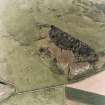
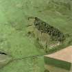
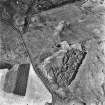
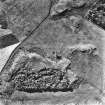
An oval enclosure defined by a D-shaped arc of bank and the edge of a rock outcrop is situated on a rise at the N end of a ridge in an improved pasture field. It measures 17.5m from ENE to WSW by 9m internally and the grass-grown earthen bank is 1.4m in thickness and 0.2m in height. About 15m to the WNW, on the slope below the enclosure, there is a rectangular spread of rubble measuring 5.7m by 5.3m; this may be the remains of a building. A drain appears to run down to the rubble and disappears beneath it. There are further stretches of stony banks within the field and at least three small clearance cairns (NG20NE 109.05).
(Canna 926-7)
Visited by RCAHMS (ARG), 11 April 1995

