
Ferryton Point


Pier (Period Unassigned)
Site Name Ferryton Point
Classification Pier (Period Unassigned)
Canmore ID 13643
Site Number NH66NE 38
NGR NH 680 670
Datum OSGB36 - NGR
Permalink http://canmore.org.uk/site/13643


- Council Highland
- Parish Resolis
- Former Region Highland
- Former District Ross And Cromarty
- Former County Ross And Cromarty
NH66NE 38 680 670
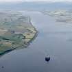
Appears to be a natural spit.
Remains of wooden pier for (?) house on shore 15m long 1m wide - highest point of board walk above beach is 2m. running back to ground level.
CFA/MORA Coastal Assessment Survey 1998.
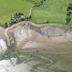
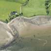
Field Visit (2013 - 2014)
Remains of a wooden pier. Highest point of boardwalk above beach is 2m, running back to ground level. 15m x 1m. Located on shore, dilapidated and under threat from tidal erosion. Built by owner of nearby house (Old Store) c. 1993. No pier there previously.
Submitted by S. Gunn, who built the pier.
Visited by Scotland's Coastal Heritage at Risk (SCHARP) 2013

