|
Photographs and Off-line Digital Images |
RC 1773 |
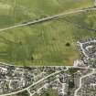
RCAHMS Aerial Photography |
Oblique aerial view. |
1977 |
Item Level |
|
|
Photographs and Off-line Digital Images |
RC 1774 |
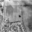
RCAHMS Aerial Photography |
Oblique aerial view. |
1977 |
Item Level |
|
|
Photographs and Off-line Digital Images |
RC 1775 |
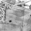
RCAHMS Aerial Photography |
Oblique aerial view. |
1977 |
Item Level |
|
 |
On-line Digital Images |
DP 093603 |
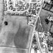
RCAHMS Aerial Photography Digital |
Oblique aerial view of the Carn Liath cairn and the cropmarks of the pits, looking SSE. |
24/7/2010 |
Item Level |
|
 |
On-line Digital Images |
SC 1695919 |
RCAHMS Aerial Photography |
Oblique aerial view. |
1977 |
Item Level |
|
 |
On-line Digital Images |
SC 1695920 |
RCAHMS Aerial Photography |
Oblique aerial view. |
1977 |
Item Level |
|
 |
On-line Digital Images |
SC 1695921 |
RCAHMS Aerial Photography |
Oblique aerial view. |
1977 |
Item Level |
|
 |
Digital Files (Non-image) |
WP 007515 |
Publications by the Royal Commission on the Ancient and Historical Monuments of Scotland |
(6) The Archaeological Sites and Monuments of Easter Ross, Ross and Cromarty District |
2/1979 |
Item Level |
|
 |
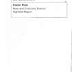
On-line Digital Images |
SC 2364568 |
Records of the Ordnance Survey, Southampton, Hampshire, England |
Alness, NH66NE 20, Ordnance Survey index card, page number 1, Recto |
1958 |
Item Level |
|
 |
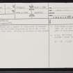
On-line Digital Images |
SC 2364569 |
Records of the Ordnance Survey, Southampton, Hampshire, England |
Alness, NH66NE 20, Ordnance Survey index card, Recto |
1958 |
Item Level |
|


