
Alness


Pit(S) (Period Unknown)
Site Name Alness
Classification Pit(S) (Period Unknown)
Canmore ID 13626
Site Number NH66NE 20
NGR NH 6656 6966
Datum OSGB36 - NGR
Permalink http://canmore.org.uk/site/13626


- Council Highland
- Parish Rosskeen
- Former Region Highland
- Former District Ross And Cromarty
- Former County Ross And Cromarty
Field Visit (September 1978)
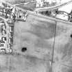
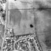
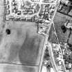
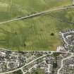
Alness, NH 665 696
There are a number of crop-marks of unknown function between the cairn described on NH66NE 10 and the Alness to Tain road. Nothing is visible on the ground.
RCAHMS 1979, visited September 1978.
(RCAHMSAP 1977)

