
Dalmore


Burial Ground (Prehistoric), Cist(S) (Prehistoric), Pit(S) (Prehistoric)(Possible), Arm Guard (Prehistoric), Bead (Prehistoric), Blade (Prehistoric), Cinerary Urn (Prehistoric)
Site Name Dalmore
Classification Burial Ground (Prehistoric), Cist(S) (Prehistoric), Pit(S) (Prehistoric)(Possible), Arm Guard (Prehistoric), Bead (Prehistoric), Blade (Prehistoric), Cinerary Urn (Prehistoric)
Canmore ID 13620
Site Number NH66NE 15
NGR NH 6641 6906
NGR Description NH 6660 6878 and NH 6640 6907
Datum OSGB36 - NGR
Permalink http://canmore.org.uk/site/13620


- Council Highland
- Parish Rosskeen
- Former Region Highland
- Former District Ross And Cromarty
- Former County Ross And Cromarty
NH66NE 15 6660 6878 and 6640 6907.
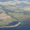
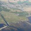
(Area: NH 665 689) A Bronze Age burial ground was discovered, in two parts, in the summer of 1878, during the construction of the branch railway from Alness station to Dalmore Distillery (NH 666 687).
The first part lay immediately above the distillery, and was apparently contained within a stone wall, the base of which could be traced along three sides, enclosing an area 108ft by 66ft, with the shorter walls running north to south. This group consisted of:-
A, a short cist with a crouched burial, a leaf-shaped flint blade, jet beads and a stone bracer.
B, six small cists containing burnt bones, some human, some animal, and, in one, what appeared to be the remains of a tanged bronze blade.
C, a cist containing an inverted cinerary urn and another smaller urn which stood the right way up and contained only gravel.
D, a circular construction of coursed stones, about 18" in internal diameter, enclosing an inverted cinerary urn and capped with a flat slab. The cinerary urn was donated to the NMAS in 1881 by Andrew Mackenzie.
E, an unenclosed burial consisting of loose bones overlaid with a few stones.
The second, presumably related, group lay at a distance of 200 yards along the line of the railway. It consisted sisted of:-
A, Two short cists with crouched burials and, in each case, a slightly decorated inverted urn which, since one contained charcoal, were presumably cinerary.
B, A cist, 3' 4" x 1'6" x 1'8", containing fragments of bone.
C, A cist of small stones enclosing a 'rough urn' and fragments of burnt bone and charcoal.
D, Burnt bones, laid on a bed of sand, with no protecting stones.
E, Three small 'rude cists , formed of stones but destitute of human or other ramains.'
A group of broken, calcined bones overlay the two short cists by several feet, implying that the latter were much earlier.
In the neighbourhood of the second group are sandy patches in the dark surface soil, similar to those which indicated the positions of the graves. These suggest that there are other graves as yet undiscovered. The 'manufactured articles' were sent to Ardross Castle.
W Jolly 1879; Proc Soc Antiq Scot 1881.
There is no trace and no local knowledge of the findspots of the burials but their approximate positions can be ascertained by deduction.
The burials found 'immediately above the distillery' must have been at the rail-head centred at NH 6660 6878, where the track cuts into a natural knoll. For a distance of 200.0m NW, the railway is on an embankment, followed by a flat stetch of line. There is no trace of the stone wall which 'contained' the burials.
The second group of burials '200 yards along the line of the railway' could have been at NH 6640 6907 where the line cuts through a small embankment. No trace could be found of any 'sandy patches' in the soil of the adjoining fields, which have long been under cultivation.
Visited by OS (N K B) 23 March 1966.
The site at NH 664 691 is on the edge of a known Bronze Age burial ground. A resistivity survey produced a localisation of anomalies in an area threatened by work on the A9 Alness bypass. Trial excavation over the anomalies only produced 4 small pits with no artifacts or datable material recovered.
Sponsor : SDD (AM)
D Reed 1985
Not visited - on Distillery property (NH66NE 23).
CFA/MORA Coastal Assessment Survey 1998.
Note (1979)
Dalmore 1 NH 666 687 NH66NE 15
During railway construction in 1878 a cemetery was found; it comprised seven cists, two cremations with urns, and an unprotected inhumation. Among the grave-goods there were two Food Vessels, a Food Vessel Urn, a bronze blade, a jet necklace, a flint knife, a stone bracer, and a bone toggle.
RCAHMS 1979
(Jolly 1879; PSAS, xv 1880-1 , 249-50; Cowie 1978, 133)
Note (1979)
Dalmore 2 NH 664 690 NH66NE 15
During railway construction in 1878 a cemetery was found; it comprised seven cists and three unprotected cremations. The only grave-goods were a Beaker and an 'urn'. Several other graves were not excavated.
RCAHMS 1979
(Jolly 1879; Clarke 1970, ii, 520, no. 17 45, 1)
Excavation (1985)
The site at NH 664 691 is on the edge of a known Bronze Age burial ground. A resistivity survey produced a localisation of anomalies in an area threatened by work on the A9 Alness bypass. Trial excavation over the anomalies only produced 4 small pits with no artifacts or datable material recovered.
Sponsor : SDD (AM)
D Reed 1985

