
Torvean


Fort (Prehistoric) - (Medieval), Motte (Medieval)(Possible)
Site Name Torvean
Classification Fort (Prehistoric) - (Medieval), Motte (Medieval)(Possible)
Canmore ID 13549
Site Number NH64SW 2
NGR NH 64378 43154
Datum OSGB36 - NGR
Permalink http://canmore.org.uk/site/13549


- Council Highland
- Parish Inverness And Bona
- Former Region Highland
- Former District Inverness
- Former County Inverness-shire
NH64SW 2 6437 4315.
(NH 6437 4315) Motte (NR)
OS 25"map, (1964)
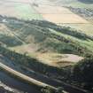
A fort stands on the top of a hill on the ridge of Torvean. It is of oval form, 100' long by 50' wide, protected by a surrounding ditch forming an irregular oval, 340' long by 200' wide, at a considerably lower level on the slopes of the hill. On the N side is another trench, intermediate between the outer ditch and the top, which has a gradual ascent towards the E end where access to the top is easiest. There appeared to be no trace of stone building in connection with this structure.
ISSFC 1921 and 1885.
Not a motte but an Iron Age fort, generally as planned by ISSFC, occupying an overgrown, steep-sided glacial ridge oriented ENE-WSW. The outer line of defence consists of a ditch cut into the slope with the material piled on its outer lip to form a rampart. In the N, where best preserved, the ditch averages c. 3.0m in width and c. 0.8m in depth
with the rampart averaging c. 4.0m in width, both are reduced to a terrace along the S slopes of the ridge. About 9.0m inside the ditch on the N is a terrace, averaging c. 1.5m in width, which may represent an unfinished line of defence. There is now no trace of its change of direction in the E as planned by ISSFC (1885).
The entrance was probably in the ENE at the easiest approach along the spine of the ridge. Here the defence terminates on the NW side of the spine, and on the SE side it is destroyed for a length of 20.0m. Any further details are obscured by a modern wall which runs along the spine and bisects the fort. The level summit, measuring about 30.0m x 14.0m, is featureless.
Surveyed at 1:2500. (visited by OS [WDJ] 1 April 1960)
(This feature was also described as a fort in 1960 by OS surveyor (WDJ); the name "Motte" appears to have been misapplied)
Visited by OS (R L) 19 Feburary 1970.
Noted as motte.
P A Yeoman 1988.
Field Visit (May 1978)
Torvean NH 644 431 NH64SW 2
This oval fort, which occupies a prominent hill, is defended by a rampart with an internal quarry ditch built some way below the summit. On the N, where best preserved, the ditch measures about 3m in width and the rampart about 4m in thickness; the entrance probably lay on the ENE where both ditch and rampart have been destroyed. In the interior there is a track of no great age.
RCAHMS 1979, visited May 1978
(Transactions of the Inverness Scientific Society and Field Club, i, 1875-80, 264; viii 1912-18, 377-8)
Note (13 March 2015 - 31 May 2016)
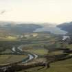
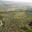
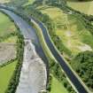
This fortification encloses one of the low summits along the crest of a narrow ridge above the NW bank of the River Ness, but while the OS surveyors who surveyed it at 1:2500 in 1960 and 1970 were in agreement that it is the remains of a fort, it was annotated Motte on the map and subsequently Scheduled as such in 1975. The level summit, which measures no more than 30m from ENE to WSW by 14m transversely, is featureless and falls away around its margin to a defensive line comprising a ditch some 3m broad and 0.8m deep, with an external rampart about 4m thick, set much lower down the slope. These defences enclose an oval area, which according to a plan drawn up about 1880 by James Fraser for the Inverness Scientific Society and Field Club, measures about 90m from ENE to WSW by 50m transversely (0.35ha); it has not been measured on the ground since and only the most general outline is visible on current satellite imagery. The entrance is on the ENE, opening on to the spine of the ridge, but its S side has been levelled over a distance of some 20m. The only feature visible within the interior are traces of an old trackway ascending to the summit on the N.
Information from An Atlas of Hillforts of Great Britain and Ireland – 31 May 2016. Atlas of Hillforts SC2898

