
Following the launch of trove.scot in February 2025 we are now planning the retiral of some of our webservices. Canmore will be switched off on 24th June 2025. Information about the closure can be found on the HES website: Retiral of HES web services | Historic Environment Scotland
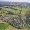
Hilton


Pit Alignment(S) (Prehistoric)
Site Name Hilton
Classification Pit Alignment(S) (Prehistoric)
Canmore ID 13524
Site Number NH64SE 40
NGR NH 6833 4351
NGR Description NH 6837 4328 to NH 6831 4364
Datum OSGB36 - NGR
Permalink http://canmore.org.uk/site/13524


- Council Highland
- Parish Inverness And Bona
- Former Region Highland
- Former District Inverness
- Former County Inverness-shire
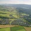
Excavation here in 1991 failed to reveal any pits although the trenches were accurately located. The cropmark of two parallel pit alignments has only been recorded once and is now thought to have been created by temporary surface soil features.
S Carter and C Russell-White 1991; S Carter and C Russell-White 1993.
Note (1979)
Hilton NH 6833 4351 NH64SE 40
Air photography has revealed the crop-marks of two pit-alignments 400m NE of the enclosure described on NH64SE 39. That to the W runs in a gentle curve for about 200m; the E example runs for a distance of about 110m parallel with the N part of the W alignment and about 7m from it.
RCAHMS 1979.
Aerial Photographic Transcription (12 June 1991 - 19 June 1991)
An aerial transcription was produced from oblique aerial photographs. Information from Historic Environment Scotland (BM) 31 March 2017.

