
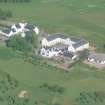
Castle Heather


Castle (Medieval)
Site Name Castle Heather
Classification Castle (Medieval)
Canmore ID 13512
Site Number NH64SE 3
NGR NH 67780 42597
Datum OSGB36 - NGR
Permalink http://canmore.org.uk/site/13512


- Council Highland
- Parish Inverness And Bona
- Former Region Highland
- Former District Inverness
- Former County Inverness-shire
NH64SE 3 6778 4260.
(NH 6778 4260) Supposed site of Castle (NR)
OS 6"map, (1938)
This is supposed to be the site of thee Castle mentioned in the Statistical Account as having existed at Castle Leathers. It is there called Castle Bathers, but that is evidently a misprint as no one knows such a name. Traces of a large building have been seen here and there are at present two hollows which appear to be the traces of the ditch. In referring to Castleleathers and Castle-heather, in 1537 the name "Castletown of Lathir" appeared in the list of the Castle lands of Inverness reprinted in the 4th volume of the Spalding Club misellany (1862) and in a manuscript of 1737 giving Major James Fraser's evidence as a witness, the name appears as "Castle Ladderis or Ladders".
Name Book 1868.
The name this castle bears, would be more suitable to a convent of Monks. It is called in English, Castle Bathers, a corruption of the Gaelic name "Caistal nan boirach", that is the castle of the "recluse or retired" a monastery in Gaelic is indifferently termed "Manachinn" the "residence of the monks" or "Leoirnamanach" the" retreat or retirement of the Monks".
Statistical Account (OSA) 1793
The estate of Castle Leathers was anciently provided with its own keep or tower.
New Statistical Account (NSA, A Rose, A Clark and R Macpherson) 1839.
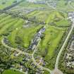
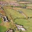
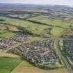
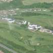
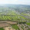
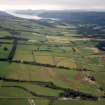
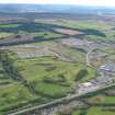
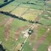
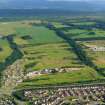
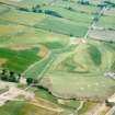
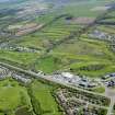
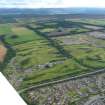
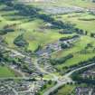
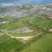
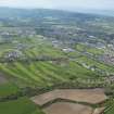
The site of the castle is a levelled-off area situated on a gentle N-facing slope. The site is a subrectangular platform measuring c. 40.0m along three sides, and c. 30.0m along the SE side. It is 1-2.0m high. Surrounding it on three sides is a broad ditch varying from c. 20.0m. wide on the east side to c. 80m. on the NW. The counterscarp of the ditch has been ploughed down at the north angle, and the turn is only just discernible. On the SW side is the natural slope to a burn. The site has been used as a dumping ground for field stones and rubbish. No traces of buildings exist on the platform. It is known locally as the site of Castle Heather.
Revised at 1/2500.
Visited by OS (JLD) 27 March 1962.
An air photograph, taken by Jill Harden in 1989, is in Inverness Museum (8904.02 INVMG).
Information from J Harden 1989.
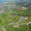
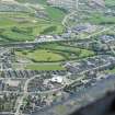
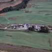
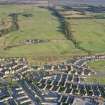
Castle Heather, severely damaged in 1990, was examined by means of eight machine trenches. Two undated post holes were recorded. No trace of defensive ditches was found and the monument is now so truncated as to be considered destroyed.
Sponsor M J Mackenzie
Wordsworth 1994c.
Field Visit (16 August 1943)
This appears to be the site of a castle, but there is nothing of interest to be seen except the remains of a ditch.
Visited by RCAHMS (A Graham) 16 August 1943.
OS ref: xi ('Earthworks')
Field Visit (April 1979)
Castle Heather NH 678 426 NH64SE 3
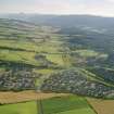
An earth-and-stone platform lying 250m SW of Castle Heather farmhouse is all that survives of this castle, which is first mentioned in 1537 but was levelled before 1793. The castle, which is traditionally associated with the Cumming family, has also been called Castle Bathers and Castle Leathers.
RCAHMS 1979, April 1979
Stat Acct, ix, 1793, 633-4; Name Book, Inverness, no. 31, pp. 9, 40
Watching Brief (August 1994)
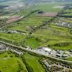
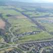
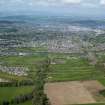
An archaeological watching brief was carried out by J Wordsworth in August 1994 in advance of the construction of a golf course on Castle Heather Farm.

