
Stoneyfield


Cup Marked Stone (Prehistoric), Kerb Cairn (Prehistoric), Brooch (Roman), Food Vessel (Bronze Age), Unidentified Pottery, Urn (Prehistoric)
Site Name Stoneyfield
Classification Cup Marked Stone (Prehistoric), Kerb Cairn (Prehistoric), Brooch (Roman), Food Vessel (Bronze Age), Unidentified Pottery, Urn (Prehistoric)
Alternative Name(s) Raigmore
Canmore ID 13414
Site Number NH64NE 6
NGR NH 68780 45490
Datum OSGB36 - NGR
Permalink http://canmore.org.uk/site/13414


- Council Highland
- Parish Inverness And Bona
- Former Region Highland
- Former District Inverness
- Former County Inverness-shire
NH64NE 6 6878 4549.
(NH 6878 4549) Cairn Circle (NR)
OS 1:10,000, map, (1971)
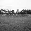
At Stoneyfield are the remains of a Clava-type cairn. All that remains is the major part of an impressive cairn kerb, 58' indiameter. The cairn itself and the internal structure have been removed, though when seen by Anderson (J Anderson 1831) in about 1824 the cairn seems to have been fairly complete. The stones forming the kerb are massive boulders, the largest being on the SW arc - the tallest, a leaning stone at the S end of this arc, 4'9" high - and other stones are 4'6" to 4'3" high. The stones in the NE arc are 1'9" to 2'9" high. Many stones have fallen inwards or outwards but have not been disturbed, and several have been reduced by blasting. There is no sign, nor it there any record, of monoliths which may once have surrounded the cairn.
In 1760 two stone circles were recorded at Stoneyfield. (a, b) (This feature was first published on OS 6"map as "Stone Circle").
A S Henshall 1963; R Pococke 1887; New Statistical Account (NSA, A Rose, A Clark and R Macpherson) 1845, G Anderson 1831; J Fraser 1884; Visited by OS (W D J) 30 March 1960.
Later finds from this cairn, excavated in 1972 and 1973, included a 2nd century Roman brooch and a sherd of coarse ware.
D D A Simpson 1973, 1974.
The excavation of this cairn in 1972-3 revealed that beneath it there had been a ractangular timber building, 9.5m long with a central stone hearth, probably associated with a series of pits containing Grooved Ware. The cairn itself consisted of a heavy stone kerb with traces of
an external stone platform on the W; in the central area there was a series of pits and cists, some of them contemporary with the cairn, some later. Several of the pits contained cremations, and in one of the cists there was a Food Vessel. A Cordoned Urn with a cremation had also been deposited in the cairn. Other articles found included a cup-marked stone, a 2nd century Roman brooch, and a sherd of coarse ware.
A S Henshall 1963; D D A Simpson 1973, 1974; RCAHMS 1979.
The kerb of this cairn was re-erected at NH 6878 4508 in advance of a new road, which now occupies the original site.
Resurveyed at 1:1250. Photos.
Visited by OS 26 January 1979.
Note (1979)
Stonifield NH 687 454 NH64NE 6
The excavation of this cairn in 1972-3 revealed that beneath it there had been a rectangular timber building, 9.5m long with a central stone hearth, probably associated with a series of pits containing Grooved Ware. The cairn itself consisted of a heavy stone kerb with traces of an external stone platform on the W; in the central area there was a series of pits and cists, some of them contemporary With the cairn, some later. Several of the pits contained cremations, and in one of the cists there was a Food Vessel. A Cordoned Urn with a cremation had also been deposited in the cairn.
RCAHMS 1979
(Henshall 1963-72, i, 384;Archaeological Excavations, 1972, 14; 1973, 109)
Excavation (1 May 2013 - 5 May 2013)
NH 68780 45080 (Canmore ID: 13414. SMR ID: 24979) The Raigmore Ring Cairn is a partially reconstructed prehistoric monument that was excavated in the early 1970s and moved to its present location, within Ashton Road Park, ahead of its destruction by the expansion of the A9 trunk road. The monument was the focus of a desk-based research project
by a local adult learners group. Through their research, the group identified contemporary photographs from the time of the site’s reconstruction, which indicated internal structural features used and reconstructed from the original monument. These features included a timber post-built
structure, a cairn platform, pits and a cist. The features were, over time, covered by vegetation or were removed and are no longer visible. The main aims and objectives of the project were to ascertain the level of survival of the internal features and assess the condition of the upstanding remains. In turn it was the aim of the project to transform the monument from an un-utilised feature within a public park to an educational resource to be used by local schools and appreciated by the whole community. Five trenches
were excavated within the interior of the monument, 1–5 May 2013, in order to investigate the presence and condition any archaeological remains. Features identified during the excavation included: a number of concrete foundations used to support wooden posts, which were in the approximate location of those found in the original monument; fragments
of the relocated original cairn material; and, the concrete foundations and the stones of the reconstructed cist.
Archive and report: HES (intended)
Funder: HLF and HES
Cara Jones – Archaeology Scotland
(Source: DES, Volume 17)
Standing Building Recording (May 2019 - October 2019)
NH 68787 45085 Between May and October of 2019 a programme of survey and recording was undertaken of the relocated Raigmore kerb cairn (Canmore ID: 13414), as part of the Canal College 2 (CC2) scheme. Canal College is Keep Scotland Beautiful and Scottish Canal’s training and youth employability scheme supported by Archaeology Scotland. The project continued work undertaken at the site by Archaeology Scotland in 2013, which comprised a five day excavation with members of the local community (DES 2016, 105).
The upright stones forming the ring cairn were surveyed using plane table and total station, and each stone was recorded using photography and monument condition recording sheets, to produce an accurate and up-to-date plan of the site, and a record of the condition of the monument.
Archive: NRHE (intended)
Funder: Archaeology Scotland and Keep Scotland Beautiful
Rebecca Barclay, Ian Hill and Kieran Manchip - Archaeology Scotland, Heritage and Archaeological Research Practice
(Source: DES Vol 20)
Note (16 January 2021)
Date Fieldwork Started: 16/01/2021
Compiled by: NOSAS
Location Notes: The grid reference given is the original site of the cairn (now under the A9) which has been relocated to NH 68785 45094. There are no cupmarks on the stones present. The report on the rescue excavation "Excavation of a kerbed funerary monument at Stoneyfield, Raigmore, Inverness, Highland, 1972-3 Derek D A Simpson, Proc Soc Antiq Scot, 126 (1996), 53-86", states "Pit 9, contained a stone with a single cup-mark on its under-surface (illus 9)". The illustration shows the stone as being about 0.4m x 0.3m. It was not found, and the image is unlike any of the stones in Inverness Museum.
Additional Description: NH 68780 45080 (Canmore ID: 13414. SMR ID: 24979) The Raigmore Ring Cairn is a partially reconstructed prehistoric monument that was excavated in the early 1970s and moved to its present location, within Ashton Road Park, ahead of its destruction by the expansion of the A9 trunk road. The monument was the focus of a desk-based research project
by a local adult learners group. Through their research, the group identified contemporary photographs from the time of the site?s reconstruction, which indicated internal structural features used and reconstructed from the original monument. These features included a timber post-built
structure, a cairn platform, pits and a cist. The features were, over time, covered by vegetation or were removed and are no longer visible. The main aims and objectives of the project were to ascertain the level of survival of the internal features and assess the condition of the upstanding remains. In turn it was the aim of the project to transform the monument from an un-utilised feature within a public park to an educational resource to be used by local schools and appreciated by the whole community. Five trenches
were excavated within the interior of the monument, 1?5 May 2013, in order to investigate the presence and condition any archaeological remains. Features identified during the excavation included: a number of concrete foundations used to support wooden posts, which were in the approximate location of those found in the original monument; fragments
of the relocated original cairn material; and, the concrete foundations and the stones of the reconstructed cist.
Archive and report: HES (intended)
Funder: HLF and HES
Cara Jones ? Archaeology Scotland
(Source: DES, Volume 17)
NH64NE 6 6878 4549.
(NH 6878 4549) Cairn Circle (NR)
OS 1:10,000, map, (1971)
At Stoneyfield are the remains of a Clava-type cairn. All that remains is the major part of an impressive cairn kerb, 58' indiameter. The cairn itself and the internal structure have been removed, though when seen by Anderson (J Anderson 1831) in about 1824 the cairn seems to have been fairly complete. The stones forming the kerb are massive boulders, the largest being on the SW arc - the tallest, a leaning stone at the S end of this arc, 4'9" high - and other stones are 4'6" to 4'3" high. The stones in the NE arc are 1'9" to 2'9" high. Many stones have fallen inwards or outwards but have not been disturbed, and several have been reduced by blasting. There is no sign, nor it there any record, of monoliths which may once have surrounded the cairn.
In 1760 two stone circles were recorded at Stoneyfield. (a, b) (This feature was first published on OS 6"map as "Stone Circle").
A S Henshall 1963; R Pococke 1887; New Statistical Account (NSA, A Rose, A Clark and R Macpherson) 1845, G Anderson 1831; J Fraser 1884; Visited by OS (W D J) 30 March 1960.
Later finds from this cairn, excavated in 1972 and 1973, included a 2nd century Roman brooch and a sherd of coarse ware.
D D A Simpson 1973, 1974.
The excavation of this cairn in 1972-3 revealed that beneath it there had been a ractangular timber building, 9.5m long with a central stone hearth, probably associated with a series of pits containing Grooved Ware. The cairn itself consisted of a heavy stone kerb with traces of
an external stone platform on the W; in the central area there was a series of pits and cists, some of them contemporary with the cairn, some later. Several of the pits contained cremations, and in one of the cists there was a Food Vessel. A Cordoned Urn with a cremation had also been deposited in the cairn. Other articles found included a cup-marked stone, a 2nd century Roman brooch, and a sherd of coarse ware.
A S Henshall 1963; D D A Simpson 1973, 1974; RCAHMS 1979.
The kerb of this cairn was re-erected at NH 6878 4508 in advance of a new road, which now occupies the original site.
Resurveyed at 1:1250. Photos.
Visited by OS 26 January 1979.

