
Parkhead


Enclosure(S) (Period Unassigned), Farmstead (Period Unassigned), Field Boundary(S) (Period Unassigned), Quarry (Period Unassigned), Rig And Furrow (Medieval)
Site Name Parkhead
Classification Enclosure(S) (Period Unassigned), Farmstead (Period Unassigned), Field Boundary(S) (Period Unassigned), Quarry (Period Unassigned), Rig And Furrow (Medieval)
Canmore ID 134128
Site Number NS83SE 48
NGR NS 87099 31315
NGR Description Centred on NS 8635 3145
Datum OSGB36 - NGR
Permalink http://canmore.org.uk/site/134128


- Council South Lanarkshire
- Parish Douglas
- Former Region Strathclyde
- Former District Clydesdale
- Former County Lanarkshire
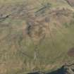
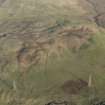
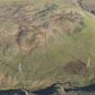
NS83SE 48 Centred on 8635 3145
Site recorded during an archaeological evaluation conducted on 30 alternative route elements, with a combined length of c84km, for a proposed road linking the M8 near Whitburn, Lothian Region with the M6/M74 near Douglas, Clydesdale District.
NS 861 315 Rig-and-furrow cultivation, enclosures, quarry
NS 863 314 (approx) Deserted settlement
NS 865 312 (area) Field banks
An illustrated report will be deposited with the NMRS.
Sponsor: Roads Directorate of The Scottish Office Industry Department, managed on its behalf by Historic Scotland.
A J Dunwell and R J Strachan 1995.

