|
Prints and Drawings |
DC 23278 |
Records of Historic Scotland, Edinburgh, Scotland |
Plans, elevation and section of one of the four proposed barracks at Cromwell Fort, Inverness |
1746 |
Item Level |
|
|
Prints and Drawings |
DC 23273 |
Records of Historic Scotland, Edinburgh, Scotland |
Plan for building a fort at Inverness on the vestige of an old fort demolished 1746, Cromwell's Fort, Inverness |
c. 1747 |
Item Level |
|
|
Prints and Drawings |
DC 23284 |
Records of Historic Scotland, Edinburgh, Scotland |
Description of the present state and situation of the remains of Oliver's Fort at Inverness, cover page and page 1 |
30/5/1747 |
Item Level |
|
|
Prints and Drawings |
DC 23285 |
Records of Historic Scotland, Edinburgh, Scotland |
Description of the present state and situation of the remains of Oliver's Fort at Inverness, pages 2 and 3 |
30/5/1747 |
Item Level |
|
|
Prints and Drawings |
DC 23286 |
Records of Historic Scotland, Edinburgh, Scotland |
The new designed fort to be built on the same ground that Oliver's Fort is on, Inverness, pages 4 and 5 |
30/5/1747 |
Item Level |
|
|
Prints and Drawings |
DC 23289 |
Records of Historic Scotland, Edinburgh, Scotland |
Estimate for building a new fort at Inverness upon the same ground where Oliver's Fort stood, pages 10 and 11 |
30/5/1747 |
Item Level |
|
|
Prints and Drawings |
DC 23290 |
Records of Historic Scotland, Edinburgh, Scotland |
Estimate for building a new fort at Inverness upon the same ground where Oliver's Fort stood, page 12 |
30/5/1747 |
Item Level |
|
|
Prints and Drawings |
DC 23287 |
Records of Historic Scotland, Edinburgh, Scotland |
Observations on Mr Camppbell's estimate for the new designed fort to be built on the same ground that Oliver's Fort is on, Inverness, pages 6 and 7 |
30/5/1747 |
Item Level |
|
|
Prints and Drawings |
DC 23288 |
Records of Historic Scotland, Edinburgh, Scotland |
Estimate for building a new fort at Inverness upon the same ground where Oliver's Fort stood, pages 8 and 9 |
30/5/1747 |
Item Level |
|
 |
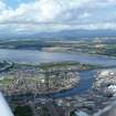
On-line Digital Images |
SC 1865193 |
Papers of James Sloan Bone, landscape historian, Inverness, Highland, Scotland |
An oblique aerial view of Inverness, looking E. |
1995 |
Item Level |
|
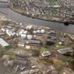 |
On-line Digital Images |
SC 1867199 |
Papers of James Sloan Bone, landscape historian, Inverness, Highland, Scotland |
Aerial view of Cromwell's Fort, Harbour Area, Inverness, looking W. |
1996 |
Item Level |
|
 |
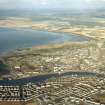
On-line Digital Images |
DP 343465 |
Papers of James Sloan Bone, landscape historian, Inverness, Highland, Scotland |
Oblique aerial view of Inverness Harbour, South Kessock and the Beauly Firth with Ben Wyvis beyond, Inverness, looking NW. |
7/8/2014 |
Item Level |
|
 |
Digital Files (Non-image) |
WP 007517 |
Publications by the Royal Commission on the Ancient and Historical Monuments of Scotland |
(8) The Archaeological Sites and Monuments of North-east Inverness, Inverness District |
10/1979 |
Item Level |
|
 |
On-line Digital Images |
SC 2363914 |
Records of the Ordnance Survey, Southampton, Hampshire, England |
Inverness, Cromwell Road, Cromwell's Fort, NH64NE 4, Ordnance Survey index card, page number 1, Recto |
1958 |
Item Level |
|
 |
On-line Digital Images |
SC 2363915 |
Records of the Ordnance Survey, Southampton, Hampshire, England |
Inverness, Cromwell Road, Cromwell's Fort, NH64NE 4, Ordnance Survey index card, page number 2, Verso |
1958 |
Item Level |
|
 |
On-line Digital Images |
SC 2363916 |
Records of the Ordnance Survey, Southampton, Hampshire, England |
Inverness, Cromwell Road, Cromwell's Fort, NH64NE 4, Ordnance Survey index card, page number 3, Recto |
1958 |
Item Level |
|
 |
On-line Digital Images |
SC 2363917 |
Records of the Ordnance Survey, Southampton, Hampshire, England |
Inverness, Cromwell Road, Cromwell's Fort, NH64NE 4, Ordnance Survey index card, page number 4, Verso |
1958 |
Item Level |
|
 |
On-line Digital Images |
SC 2363918 |
Records of the Ordnance Survey, Southampton, Hampshire, England |
Inverness, Cromwell Road, Cromwell's Fort, NH64NE 4, Ordnance Survey index card, Recto |
1958 |
Item Level |
|
 |
On-line Digital Images |
SC 2363919 |
Records of the Ordnance Survey, Southampton, Hampshire, England |
Inverness, Cromwell Road, Cromwell's Fort, NH64NE 4, Ordnance Survey index card, Recto |
1958 |
Item Level |
|
|
All Other |
551 30/16/57 |
Records of CFA Archaeology Ltd, archaeologists, Musselburgh, East Lothian, Scotland |
Archive from an evaluation and excavation of Inverness Oil Terminal |
10/2010 |
Sub-Group Level |
|
|
All Other |
551 166/1/1 |
Records of the Ordnance Survey, Southampton, Hampshire, England |
Archaeological site card index ('495' cards) |
1947 |
Sub-Group Level |
|
|
All Other |
551 419/2/3 |
Highland Archaeology Services Ltd |
Archive from excavation at Cromwell's Fort, Cromwell Road, Inverness. |
6/5/2005 |
Sub-Group Level |
|


