
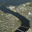
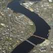
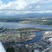
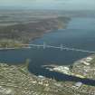
Inverness Harbour


Harbour (Medieval)
Site Name Inverness Harbour
Classification Harbour (Medieval)
Alternative Name(s) River Ness; Longman; Water Of Ness; Chapel Inch; Carnac Point
Canmore ID 13345
Site Number NH64NE 129
NGR NH 6640 4620
NGR Description Centred NH 6640 4620
Datum OSGB36 - NGR
Permalink http://canmore.org.uk/site/13345


- Council Highland
- Parish Inverness And Bona
- Former Region Highland
- Former District Inverness
- Former County Inverness-shire
NH64NE 129.00 centred 6640 4620
Harbour [NAT] (name centred NH 6638 4625)
OS 1:10,000 map, 1992.
Not to be confused with Caledonian Canal, Clachnaharry basin (NH 6481 4661 to NH 6451 4672), for which see NH64NW 30.03 or Muirtown Basin (NH 6538 4583 to NH 6500 4644), for which see NH64NE 120.00.
For Cairn Arc (beacon, at NH 6597 4726), see NH64NE 5.
For burgh of Inverness (centred NH 6665 4539), see NH64NE 97.
For shipyard, crane and sheerlegs at Thornbush Quay (centred NH 6610 4645), see NH64NE 128.00.
NH64NE 129.01 NH 663 465 post crane
NH64NE 129.02 Centred NH 6635 4592 Old Harbour
NH64NE 129.03 Centred NH 6598 4660 Thornbush Quay
NH64NE 129.04 NH c. 6634 4592 Old Quay
NH64NE 129.05 NH c. 6642 4618 Citadel Quay
NH64NE 129.06 NH c. 6642 4618 New Quay
NH64NE 129.07 NH 66415 46025 Shore Street Quay
NH64NE 129.08 NH 66383 45943 Harbour Office
NH64NE 129.09 Cancelled: see NH64NE 128.02.
NH64NE 129.10 NH 65998 47244 to NH c. 65876 46886 Western Breakwater
NH64NE 129.11 NH 66032 46295 to NH c. 66182 46897 Eastern Breakwater
NH64NE 129.12 NH 66159 46680 Longman Quay
NH64NE 129.13 NH 6603 4693 Beacon
(Location cited as NH 663 463). Inverness Harbour, rebuilt 1847 and later, engineer Joseph Mitchell. A series of quays along both banks of the River Ness; the E bank is now most important. Here there are small one- and two-storey rubble warehouses, a rail conection (rare nowadays), and (at NH 663 465) a wood and cast-iron post crane [NH64NE 129.01] similar to that at Muirtown, on the Caledonian Canal.
J R Hume 1977.
(Location cited as NJ [NH] 665 460): Inverness.
Summary.
Development of the harbours of Inverness up to 1850 took place in three main stages, focusing successively on particular sections of river banks, the sites respectively of the three harbours being mentioned in the New Statistical Account. From the earliest times to the 17th century, the right [E] bank at the Maggot, where fords connected the beginnings of the town with the Merkinch [name: NH 659 460] and Kessock ferry [South Kessock Pier: NH64NE 152], served fishermen, shipbuilders and traders with the outside world. The second phase, of extension downstream on the right [E] bank, saw the siting of the Cromwellian citadel (Cromwell's Fort: NH64NE 4) between the Maggot and the sea, in a position to control both access to the original harbour and the Merkinch road to Kessock. The new harbour in the S ditch of the Citadel, and the Old Quay [NH64NE 129.04] as re-planned before 1821, failed to accommodate all the developments of communications and trade as these expanded after 1745. In the third phase, the Merkinch ceased to be an island, facilitating development on the left [W] bank, with Thornbush Quay (NH64NE 129.03) as its focal point.
It is idle to speculate on the origin of the port at Inverness, as historical records fail us; at the same time, the site obviously possesses such natural advantages as would have attracted sea-going people at any period. The delta of the River Ness provided, up to the late 18th century, more than one mouth for the river. Its conformation, even the numbers of islands, may have changed considerably from time to time. The main island in medieval and early modern times was the Merkinch, the northern tip of which forms the S shore of the Kessock narrows (around NH 465 476], at the mouth of the Beauly Firth. Views of Inverness in the 18th century, including the drawing by P Sandby made in 1774, show water flowing in the Nabon, between the Merkinch and the left-bank mainland. The crossing of the Nabon at Bowbridge, later called 'The Stones' was wet within the memory of persons alive in 1881, and the area on the right bank known as the Maggot was thought to have been an island in the 16th century. Avery's map (1725-30) also shows the Merkinch as an island. Fords existed, one near the precursors of the modern Waterloo and railway bridges (NH64NE 131 and NH64NE 130 respectively). Wordsworth has suggested that the level ground [around NH 663 456] on the right bank near to these fords and to the parish church (NH64NE 13.00) is likely to have been the site of the burghal nucleus. A settlement here would always have enjoyed shelter among the islands of the river mouth for its boats, and access at a distance of less than two miles to the safe and extensive anchorage in the Kessock narrows, on a natural E-W traffic route linking Moray with the Beauly district and Strath Farrar. Supplies of shipbuilding timber would also have existed up-country, with the River Ness available for the driving of logs. In view of these facts it is unlikely that so attractive a potential port would have lain unused until an Anglo-Norman burgh was created by a 12th-century King of Scots; and it is probably safe to think of a customary landing or landings in the estuary as having long been used by communities of fishermen, traders or pirates. In historical times, again, whatever may have been the date of the town's erection as a Royal Burgh - a point which does not seem to have been clearly established - it is hard to imagine any trading community, irrespective of its legal status, failing to provide itself with organised shipping facilities of one kind or another. This seems to apply to Inverness with particular force in view of its later reputation as a shipbuilding port.
The history of the harbour as it developed in later times should be viewed in the light of a parish in the New Statistical Account, which states that three harbours were made at different times in the mouth of the River Ness. The writer may be supposed to have had in mind: (1) the Old Quay [NH c. 6634 4592: NH64NE 129.04], situated in modern terms between the Waterloo Bridge and the railway viaduct; (2) the Citadel Quay [NH c. 6642 4618: NH64NE 129.05], adjoining Cromwell's fort [NH64NE 4]; (3) Thornbush Quay [NH 659 466: NH64NE 129.03], on the left bank of the river and further downstream. The burgh presumably enjoyed full liberty in the choice of sites for its harbours, as a charter of 1641, which purports to confirm earlier unquoted charters dating back to William the Lyon, specifies as burgh property '…all portes, heavines and cruikes' on both sides of the water of Ness [River Ness], from a stone known as Clash na haggag [Clachnaharry] to the sea, together with the fishery landing places at North and South Kessock and the right of working the ferry.
The position of the Old Quay [NH64NE 129.04] is given by A D Cameron (1975, 232), and his conclusion is supported by Wood's Plan of Inverness (1821) and the Report of the Boundaries Commission (1832). Earlier evidence comes from a Macfarlane document of the 17th century, which alludes to a road to the harbour distinct from another leading to Kessock ferry, the former presumably following a line corresponding generally with Church Street; while Slezer shows in his view of Inverness three good-sized boats berthed at the point in question, with smaller boats beached nearby. G Cameron (1847, 33) would appear to place the site further upstream, as he states that the 'oldest part of the harbour was built in 1675', and this would imply a connection between it and the seven-arched masonry bridge near the Castle (NH64NE 9), which was, in fact, built at about that date - 'lately' as Slezer put it in 1693. However, a bridge was recorded in the early 17th century, and in 1596 a bridge and harbour were both in need of repair, all of which suggests that Cameron confused two bridges, applying to the one mentioned in 1596, the date 1675, which belongs, properly, as has been said, to the stone bridge near the Castle. No weight need therefore be given to his dating of the harbour, or to whatever this might seem to imply in respect of position.
For the old harbour's true, or at least approximate, age, evidence is given by the record of 1596, as quoted above. That is to say, the works, whatever they were, must presumably have been standing for a longish time to have earned the epithet 'decayit', and to require an impost for their repair. This fact might well put their origin back to the beginning of the century or earlier. Repairs were again being discussed in 1660. The harbour of the early 17th century was described as treacherous, and able to take only small craft: 'portu infido et minorum capaci'.
The second harbour of the series envisaged by the New Statistical Account was built in the third or fourth decade of the 18th century, A D Cameron dating it to between 1725 and 1732 and G Cameron to 1738. G Cameron writes of an 'excellent beach' about 160yds (146m] long extending downstream from the Old Quay - no doubt the one on which Slezer showed the boats drawn up - and he places the New Quay [NH64NE 129.06] at the end of this, close to the remains of the citadel [NH64NE 4]. This latter faced the river on the W, and was enclosed on the N, E and S by a wet ditch. A D Cameron describes the New Quay as lying 'at right angles to the river outside the southern defensive mound', and notes that it is shown on Hume's plan of 1774. Precisely to what extent the adjoining part of the moat was included in the works is not clear, but Slezer's view shows that in 1693, that is to say before their construction, entry to it was blocked by a row of stakes. According to A D Cameron, this harbour was never completed, as the funds ran out, though it was certainly in use, and was repaired, at some date after 1803. A plan in Inverness Museum, dated 1729 and initialled 'A.M.', sets out fully a project for developing a harbour in the most. A basin at the opening into the S ditch of the citadel was to be fed with, and scoured by incoming tide-water, entering the N ditch from seaward and flowing round by the E (landward) ditch. Sluices are shown both at the opening into the N ditch and at the closure of the new harbour from the rest of the S ditch. It was calculated that nearly 60,000 tons of water would run off from between the sluices in three hours. Hume's plan shows that by 1774 the opening of the S ditch had been widened for use as a harbour, but neither this nor Hume's plan shows any sluices. Fraser described the Citadel and published a plan of the conversion in the 1730's as a harbour, quoting a cost of £2700. Such a sum may well have been insufficient for the full realisation of the 1729 scheme.
At the end of the 18th century, the Statistical Account described the harbour, presumably the whole complex within the estuary, as being 'safe, commodious, and kept in excellent repair. While it is possible, partly in view of what is known of the Town Council's attitude in immediately succeeding decades, to suspect that the writer of 1793 was influenced by a local patriotism, the harbour was not totally neglected. The New Harbour, as marked on Wood's plan in 1821, occupied over half the length of the S ditch of the Citadel, with a bridge at its head giving access to buildings on the Citadel site. If this New Harbour was indeed only a partial realisation of the 1729 plan, lacking the scour of its proposed sluices, then its appearance on Leslie's plan of 1846 as 'Old Tidal Basin', and the need for new tidal basins, as also shown on Leslie's plan, to the E, up to a new cur between the Muscle Scalps, and on the W bank to the S of Thornbush Quay [NH64NE 129.03], would be readily explicable. The Harbour Commissioners' statement in 1847 that the harbour 'with the exception of Thornbush Quay [NH64NE 129.03] and a small dock near the Town, remains in a state of nature' may be in part a reflection of the failure to build new tidal basins, such as were envisaged in connection with Leslie's plan, but never built.
The 'small dock near the Town' referred to by the Commissioners was probably the old tidal basin in the S ditch of the citadel. In the same year, however, G Cameron's reference to an Old Quay 160yds (146m) upstream nearer the town draws attention to a stretch of the right bank of the River Ness of importance to trade and communications from very much earlier times. Ross (1883) recorded memories of persons who had seen, possibly in the late 18th century, boats passing as far as the foot of Chapel Street, an area connected with the Castle by a road, now Church Street, along the line of which the town had grown up. The Maggot Ditch shown in Hume's plan of 1774 could have taken small boats only so far, and the line of the river bank was altered at the time of the building of the Black Bridge [NH64NE 767] (a forerunner of the Waterloo Bridge [NH64NE 131]) in 1808. Wood's plan of 1821 shows the right bank below this bridge cut back to run due E across the former mouth of the Maggot Ditch before turning N, then ESE, then N again for 160yds (146m), and finally forming a similar but larger projection into the tideway at the mouth of the tidal basin in the Citadel ditch. An Admiralty survey of 1845 shows no change. A Ministry of Transport plan (SRO, RHP 1117) labels the 30yd (27.4m) stretch running northwards from a point 50yds (45.7m) E of the bridge 'Old Quay' and the longer stretch from there to the Citadel Quay 'Wooden Quay'. Both abutments of the tidal dock in the Citadel ditch are shown as stone quays having river faces 70yds (63.9m) in length.
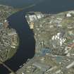
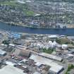
Thornbush Quay [NH64NE 129.03], the third of the harbours covered by the passage quoted above from the New Statistical Account stood on the W side of the estuary some 600yds (548m) below the Citadel Quay, and is shown on a plan surveyed in 1844 as a stretch of riverbank wharfage about 180yds (164.5m) in length. Its origin and functions cannot, however, be considered in dissociation from fresh factors introduced by the construction of the terminal section of the Caledonian Canal (NH64NW 30.00 and NH64NE 120.00: LIN 19). The Canal was authorised by Parliament in 1803, and was begun under T Telford as principal engineer with W Jessup as consultant. The terminal works consisted of a sea-lock (NH64NW 28.00) at Clashnaharry [Clachnaharry], giving access to a lower basin (NH64NW 30.03), and from this a second lock (NH64NW 30.02) led into Muirtown basin (NH64NE 120.00), which is shown on the plan published by the Harbour Commissioners as measuring about 900yds (822.6m) in length by up to 200yds (183m) in breadth. It was intended primarily to serve the Inverness trade, and the New Statistical Account notes that ships too large to negotiate the estuary were worked from the Canal's wharves. The basin was almost completed by 1807, but difficulties encountered in the building of the sealock delayed progress until 1811, and the canal as a whole was not opened until 1822. Large scale repairs became necessary in 1843, and the waterway was finally reopened only in 1847.
The building of the Caledonian Canal had important effects on the fortunes of Inverness harbour. Constructional work on the terminal locks and basins brought much new business to its quays, but the Town Council, since ceasing work on the Citadel Quay, had consistently scamped expenditure on the harbour's upkeep, and the fresh revenue was accordingly absorbed into the Common Good while the harbour was allowed to deteriorate. As a result, after the completion of the Muirtown basin, shipping tended to resort to it rather than to the Town's quays, and it was evidently the threat of competition from this quarter that led the council to repair the Citadel Quay, and to build Thornbush Quay in 1813-17. The latter work accommodated ships of up to 250 tons, and according to the Town Clerk's evidence to the Tidal Harbours Commissioners, further unspecified improvements were made in 1813-18, 1826 and 1837-45. Nevertheless, the Commissioners in their report blamed the Town Council for failing to take advantage of such natural features as a 14ft (4.25m) rise of tide and the absence of a bar. Again, two Admiralty surveyors pointed in their evidence to insufficient outlay on maintenance, and emphasised the need for dredging in the estuary's channel. They stated that the chief cause of navigational difficulties was the steep angle of the river's descent from the level of Loch Ness, the fall amounting to 45ft (13.7m) in 7 miles (11.2km). As a result of this, the tide reached barely two miles (3.2km) up the estuary, the effect of the flood water going out with the falling tide was consequently feeble, and the river's string current, thus insufficiently checked, was to bring down large quantities of sand and gravel. They insisted that dredging was necessary to lessen the angle of the estuary bed's descent.
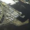
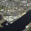
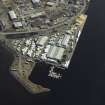
The harbour was eventually reorganised, a Harbour Trust was established, and in 1847, J Mitchell was appointed Harbour Engineer. It was Mitchell's reforms that gave the harbour its later shape, but most of the work was done after the terminal date [1850] of this study. In summary, the channel was dredged to a depth of 21ft (6.4m), Thornbush Quay [NH64NE 129.03] was extended, and on the W, embankments were one stretch protecting Chapel Inch and another carrying a tow path to Carnac Point. In the 1880's, the Citadel Quay was repaired, Shore Street Quay (NH64NE 129.07) was built by the railway company when its viaduct (NH64NE 130) cut off the Old Harbour (NH64NE 129.02) from the Citadel Quay (NH64NE 129.05), and a groyne was constructed to give the area improved shelter.
Some details of the maritime trade to which this harbour formed a background for several centuries are set out by A D Cameron. He notes that medieval charters granted the burgh a monopoly of trade with the country to the N and W, reserving the right of the burgesses to buy and sell timber, hides, fish, wool and cloth. Nearly 5000 hides were exported in 1406, and in so far as such products came from the Highland region, it is certain that lack of roads necessitated their transport by sea. Again, J Steuart, a prominent local merchant who flourished in the earlier part of the 18th century, was trading with a dozen small ships to Rotterdam, Lisbon, Barcelona and Leghorn, as well as to the West Highlands and England; his chief exports were skins, salt cod and herring to the Baltic and Holland, and salmon and herring to France and the Mediterranean. In 1720, a barque carried skins to Danzig [Gdansk] and returned with a mixed cargo of tarred rope, flax, linen, iron, glass and soap. The same owner was smuggling on the W coast. In addition to this export and import trade, shipbuilding was evidently an important local industry, a shipyard being established, in particular, at Thornbush Quay (NH64NE 129.03). This comparatively recent development is, however, far outrun by what seems to have been the local industry's scope in the middle of the 13th century. Matthew Paris recorded that, in 1249, a French crusading count, High de Chatillon, had a ship, described as 'marvellous', built at Inverness, in which he and his companions from Boulogne, Flanders and the Low Countries could be carried oversea (transfretari). A vessel which could accommodate, as we must suppose, at least four knights, with retainers to an unknown number, and possibly horses as well, on a voyage from, say, Boulogne to a Mediterranean port, naturally had little in common with the local trading craft of the 18th century, which A D Cameron rates in general at not more than 50 tons. Nor was this the only overseas order executed in the 13th century, as G Cameron states, though without giving his authority, that another French count had a replacement for a ship built for a ship lost in Orkney. On the other hand, Paris' language (navem mirabilem… paraverat in Ylvernes) could apply to work not done by a native shipyard but by a gang of skilled Low Country shipwrights sent to Scotland for the purpose, and taking advantage of a supply of suitable timber conveniently close to tide water. An analogy might be seen in the practice of English 18th century iron masters, who shipped their ore to the West Highlands and built smelters there to exploit the fuel supplied by the local woods.
Structure.
Modern construction has completely obscured the layout of the original harbour of Inverness on the site of the inlet downstream from the Maggot. Portland Place [name: NH 6634 4589], the eastern exit from the Waterloo Bridge (NH64NE 131) preserves the line of the embankment from the E end of the 1808-49 Black Bridge (NH64NE 767) across the mouth of the Maggot inlet to the point at which the Old Quay (NH64NE 129.04) diverged (in 1821) at an oblique angle NE-wards, as Shore Street does today. The Harbour Office (NH64NE 129.08), the abutment of the railway viaduct (NH64NE 130) and Shore Street Quay (NH64NE 129.07) stand today on made ground which covers over the whole site of the Old Quay (NH64NE 129.04), and is protected by the later 19th century groyne. The quay was only 30yds (27.4m) long, according to the Ministry of Transport's 1843-4 plan, and would not have extended as far downstream as the end of the groyne. Even the further 200yds (183m) of former wooden quay leaves room for G Cameron's 'excellent beach', 160yds (146.2m) long in 1847, to have occupied the site of the upstream part of the present Citadel Quay (NH64NE 129.05).
Thornbush Quay (NH64NE 129.03) retains, beneath its modernised surface, much visible masonry datable probably to 1813-17, all of red stone blocks in courses. It is an irregular rhomboidal structure, about 15ft (4.5m) high. On a foundation course of thin stone blocks, set vertically, rest 12 courses of large rectangular blocks, forming a face about 168yds (153.5m) long, slightly shorter than that of the foundation course upon which the main structure is set back a few inches. The downstream end of the Quay, battered slightly from the narrow platform on which it is set back from the top edge of the foundation course, has a flight of steps, only about 1ft (0.301m) wide, descending from the top back corner to the river front edge. At the upstream edge of the Quay, a slip 50ft (15.2m) long descends gently to the beach. Two stone pawls remain in place at the back of the quay; another lies uprooted, showing its massive foot.
[Illustrations include details copied from early plans].
A Graham and J Gordon 1988.
The location assigned to this record is essentially arbitrary. The extent of this harbour is ill-defined.
The Maggot, The Nabon, Bowbridge, Chapel Inch and Carnac Point cannot be located from the available map evidence. A location at NH c. 6642 4618 (near the S ditch of the Citadel NH64NE 4) appears probable for the Citadel Quay (NH64NE 129.05), and one in the same area for the New Quay (NH64NE 129.06).
Information from RCAHMS (RJCM), 29 March 2006.
Publication Account (2007)
Inverness Harbour
(Institute Civil Engineers Historic Engineering Works no. HEW 2534)
The harbour is located at the sheltered entrance to the Ness chiefly on the east bank of the river. The Old Quay, dating from ca.1675 which accommodated vessels of 70 to 80 tons, was an improvement on earlier arrangements dating back to 1249. The harbour was enlarged from 1725–32 when the ‘New’ or ‘Citadel’ Quay was built, following which little seems to have been done to maintain the works although the harbour dues were significant and a factor in the town’s prosperity.
In order to accommodate increased trade and traffic during the Industrial Revolution [post-mid 18th century on], Thornbush Quay on the west bank was begun in 1813 and completed in 1817. The work was done under Telford’s direction by Thomas Hughes using the unusual and economical expedient of building the masonry under water [see 'The Theory, Practice, and Architecture of Bridges of Stone, Iron, Timber, and Wire, edited by John Weale,' London, 1843, 2 vols]. The bed of the river was deepened, widened and cleansed.
Under an act of 1847, further improvements were carried out under the direction of Joseph Mitchell. The river was deepened, Thornbush Quay was extended and the Upper Quay was improved. Construction of the five-span Ness Viaduct for the Ross-shire Railway in 1862, for which Mitchell was the engineer, cut off the old harbour and resulted in Shore Street Quay being built downstream at the railway company’s expense.
In 1883 a new masonry quay was built at Shore Street in front of the old one. Further improvements were carried out in 1899 and in 1908 a new boat slipway was built at Thornbush Quay. This offered ship repair facilities for drifters and trawlers and encouraged small-scale shipbuilding,
services much used during the first and second world wars and still in use.
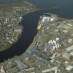
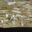
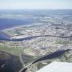
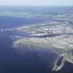
Further expansion of the harbour took place in 1985 with the construction opposite Thornbush Quay of the 600 ft long Longman Quay, the land reclamation for which can be seen in the foreground of the view.
R Paxton and J Shipway, 2007.
Reproduced from 'Civil Engineering heritage: Scotland - Highlands and Islands' with kind permission from Thomas Telford Publishers.

