
Castle Spirital


Castle (Medieval)
Site Name Castle Spirital
Classification Castle (Medieval)
Alternative Name(s) Spirodail; Spairtain; Loch-a-leg; Spioradain
Canmore ID 13165
Site Number NH63NW 15
NGR NH 6031 3810
Datum OSGB36 - NGR
Permalink http://canmore.org.uk/site/13165


- Council Highland
- Parish Inverness And Bona
- Former Region Highland
- Former District Inverness
- Former County Inverness-shire
NH63NW 15 6031 3810
(NH 60313810) Site of Castle Spirital {NR}
OS 6" map, Inverness-shire, 2nd ed., (1903).
Variously known as Castle Spiordail, Spairtain and Loch-a-leg Castle.
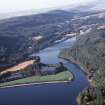
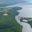
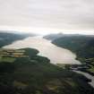
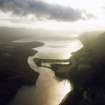
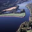
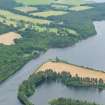
Some form of Defence must have existed at this point from the earliest times, owing to its important position by a ford (Dr Aitiken 1885). The site was originally an island (possibly a crannog) which was replaced by a small baronial keep (A Macfarline 1926). Only a part of the central fortalice is left, the remainder having been destroyed by the building of the Caledonian Canal,when the raising of the water-level submerged most of the circumvallation and buildings (A M Macfarline 1926).
Little is known of its history, but it appears to be connected with the Macleans who settled in the North c. 1420. The castle is said to have been built by Sir Hectore Maclean and destroyed in his son's time by the Camerons. (A Ross 1921, with information from C Fraser-Mackintosh notes, 665, plan)
Dr Aitiken 1885; A Ross 1921; A M Macfarline 1926.
At this site are the mutilated remains of a tree-covered mound, triangular on plan, measuring 14m N-S x 8m across the South end, over its flat top. It is 2m high on the east, or canal side, and 3m above the waters of the loch on the west, which has encroached upon the ditch which formerly isolated the castle-mound from the peninsula. The ditch has been 10-12m wide. Although the mound is partially composed of stones, no structure remains.
Anon.

